Kings Canyon NP:
• Sequoia & Kings Canyon NP


Rae Lakes loop
This is a 3 day activity in the Kings Canyon National Park.
Day 1: From Sawmill TH to Woods Lakes
Day 2: From Woods Lakes to Rae Lakes
Day 3: From Rae Lakes to Onion Valley Campground
 This is a very hard hike where you enjoy alpine views for a day and a half but
spend the rest of the time going in and out of the Kings Canyon NP. The
temperature was perfect at this time of the year. The hassle of the car
shuttle and the extremely long approach to the park border makes this trip
marginally recommended. It would have been better starting
at the Baxter Pass trailhead or doing it on the other direction. And even
better making this a 4-day hike. Another good alternative is a 5-day
trip starting at the Onion Valley Cmpgnd and exiting at the Taboose
Pass. One side trip we didn’t have time to explore is the trail to the Sixty
Lake Basin. On the map, it looks like a very worthy area to get lost.
This is a very hard hike where you enjoy alpine views for a day and a half but
spend the rest of the time going in and out of the Kings Canyon NP. The
temperature was perfect at this time of the year. The hassle of the car
shuttle and the extremely long approach to the park border makes this trip
marginally recommended. It would have been better starting
at the Baxter Pass trailhead or doing it on the other direction. And even
better making this a 4-day hike. Another good alternative is a 5-day
trip starting at the Onion Valley Cmpgnd and exiting at the Taboose
Pass. One side trip we didn’t have time to explore is the trail to the Sixty
Lake Basin. On the map, it looks like a very worthy area to get lost.
Day 1: From Sawmill TH to Woods Lakes (Kings Canyon NP)
 Facts:
Distance: 10.4 miles
Altitude at starting point: 4597 ft.
Altitude at destination point: 10926 ft.
Elevation gain: 6728 ft.
Total descent: 399 ft.
Duration: 10 h.
Date: 09/04/2010
This route starts at the Sawmill trail head. The day before, we left the first car at the parking lot of the Onion Valley Campground. On the first day of the hike, we drove the second car to the Sawmill trailhead parking lot. To get there from the south, take the 395 north. From Independence is 12.5 miles. At 8.4 miles, cross the highway and turn right at the T junction. 1.2 miles after the T, turn left and follow the road to the power plant where the pavement ends. Keep on going on the good dirt road for 0.5 miles till the Sawmill TH parking lot.
Description of the route:
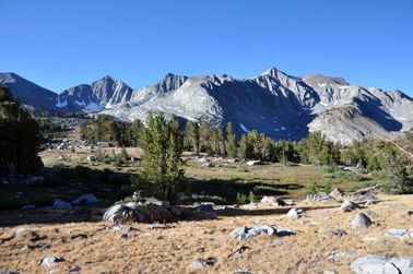
The trail starts close to the informative panel (SW01 SawmillTH). For the first mile, the terrain is a mix of sand and volcanic rocks which makes progress slow. After that, the terrain hardens and the volcanic rocks are replaced by granite gravel. This terrain and the steep slope make progress still slow.
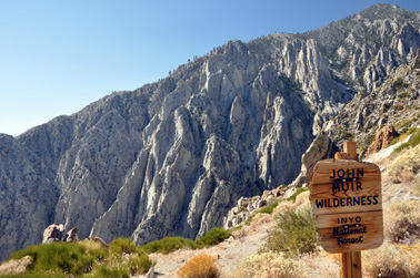
At mile 3.1 (SW02CrestJohnMWild) you’ll find the sign indicating the border of the John Muir Wilderness. This is a good lookout for the 395 valley below with the highway and the water channel. From this point, you’ll see sharp granite fins framing steep vertiginous chutes across the valley to the south. The trail continues up with a series of wide switchbacks and encountering the first pine trees. It will take you to the first pass at mile 3.3 (SW03 FirstPass). This spot is easily recognized by the big pine tree right by the side of the trail. At this point, you leave behind the desert and enter the Sierra. The trail levels out and the shade from the pine trees and occasional oaks become more frequent. As you climb up, the forest thickens and the sound of running water becomes common.
 At mile 5.4 you arrive to the Sawmill meadows where you can find nice camping
spots. The mule lake at 7.1 miles (SW12 Mule Lake) is a good
place to rest and refill water. The best place is at the beginning of the
lake as the trail goes away from the lake towards the Sawmill Lake. The stretch
between the two lakes is rocky and when we did it, there was no running water
on the creek connecting them (or very deep into the rock). The trail goes around
the Sawmill Lake (mile 7.6, SW14 Sawmill Lake) at a certain distance
also so if you need to fill water, you’ll have to deviate from the trail.
At mile 5.4 you arrive to the Sawmill meadows where you can find nice camping
spots. The mule lake at 7.1 miles (SW12 Mule Lake) is a good
place to rest and refill water. The best place is at the beginning of the
lake as the trail goes away from the lake towards the Sawmill Lake. The stretch
between the two lakes is rocky and when we did it, there was no running water
on the creek connecting them (or very deep into the rock). The trail goes around
the Sawmill Lake (mile 7.6, SW14 Sawmill Lake) at a certain distance
also so if you need to fill water, you’ll have to deviate from the trail.
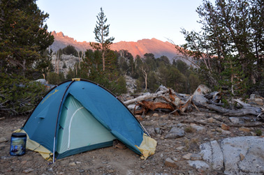
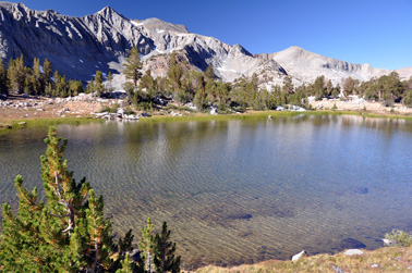
The last stretch to the pass is less steep than the section already done which makes the final climb more bearable. When you get to the top of the Sawmill Pass (mile 9.5, SW20 Sawmill Pass), don’t expect to be rewarded by magnificent views. The other side of the crest (already inside the Kings Canyon National Park) is very flat and wide open. 1 mile down the trail you’ll find the first lakes, streams and meadows. That’s where we stopped for a deserved resting night (SW22 1st Night) after 10.4 miles.
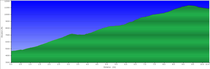
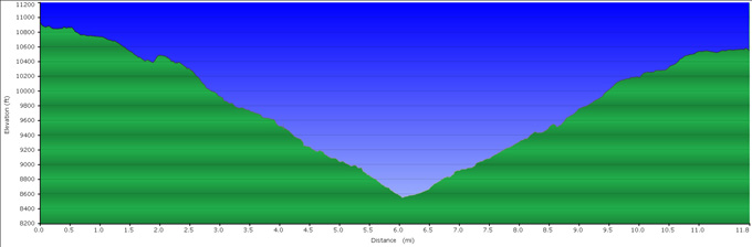
Profile from Sawmill Trail Head to Woods Lakes.
Day 2: From Woods Lakes to Rae Lakes
Facts:
Distance: 11.8 miles
Altitude at starting point: 10926 ft.
Altitude at destination point: 10550 ft.
Elevation gain: 2027 ft.
Total descent: 2378 ft.
Duration: 8 h.
Date: 09/05/2010
Description of the route:
The trail down to the PCT is sketchy and difficult to follow at some points. The first mile runs through meadows and around lakes. Since the trail is not maintained, expect the trail disappear when it crosses meadows previously covered by water. Often you can see the trail at the other end of the meadow. We also found running water on the trail. After that wet section, the next 0.75 miles are easier to follow thanks to the multiple granite stairs and ledges marked with cairns.
At mile 1.9, the trail goes up a little bit and turns north towards the PCT. Then it descends until it crosses the Woods creek (2.3 miles, WR02 WoodsCreek). Keep straight and bear a little to the right to find the PCT (WR03 PCTJunc GoLeft) 300 ft from the creek. Turn left and follow the PCT.
 The
first stretch of the PCT runs parallel to the Woods creek but the water is not
always accessible. A good spot to replenish is at the Woods creek crossing before
merging the PCT. At mile 4.0 there are good views of a waterfall. When the trail
gets closer to the creek, there is a nice pool for a refreshing swim. At mile
6.0 you will turn left (WR12 PCTJuncGoLeft) leaving the Woods
creek trail (that would take you to the Road End point at the Kings Canyon visitor
center) and following the PCT. A short distance after the junction, you will cross
the Woods creek through the huge hanging bridge. From here, the climb till the
Dollar Lake is long and steady but gentle. Although the trail runs parallel to
the south fork of the Woods creek, it’s not really close to it and access to water
is only available from small subsidiary streams.
The
first stretch of the PCT runs parallel to the Woods creek but the water is not
always accessible. A good spot to replenish is at the Woods creek crossing before
merging the PCT. At mile 4.0 there are good views of a waterfall. When the trail
gets closer to the creek, there is a nice pool for a refreshing swim. At mile
6.0 you will turn left (WR12 PCTJuncGoLeft) leaving the Woods
creek trail (that would take you to the Road End point at the Kings Canyon visitor
center) and following the PCT. A short distance after the junction, you will cross
the Woods creek through the huge hanging bridge. From here, the climb till the
Dollar Lake is long and steady but gentle. Although the trail runs parallel to
the south fork of the Woods creek, it’s not really close to it and access to water
is only available from small subsidiary streams.
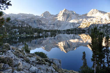
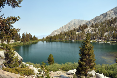
Once you get to the Dollar Lake (mile 9.9, WR17 Dollar Lake Cmpgnd), the most beautiful section of this trip begins. Meadows and streams link a chain of crystalline lakes where the surrounding peaks reflect. We camped at the largest of the Rae Lakes (mile 11.8, WR19 2nd night).
Profile from Woods Lakes to Rae Lakes.
Go to top
Day 3: From Rae Lakes to Onion Valley Campground
 Facts:
Distance: 11.9 miles
Altitude at starting point: 10550 ft.
Altitude at destination point: 9275 ft.
Elevation gain: 2392 ft.
Total descent: 3665 ft.
Duration: 5:15 h
Date: 09/06/2010
This last day starts with a beautiful image of the raising sun illuminating the top peaks of the range on the west side of the lake and its reflection on the calm waters.
Description of the route:
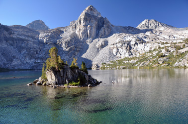
The first section of the day is my favorite stretch of the entire trip: the crossing between the Rae lakes. The trail follows a narrow passage between both lakes from where you can see the trouts through the crystal clear water. A pine tree stands atop the fortified island overlooking the tranquil waters. At mile 1, you pass the junction to the Sixty Lake Basin (RO02 JuncSixtyBasin).
 The
climb to the Glen Pass consists of a sequence of 3 steep switchback sections separated
by 2 flat stretches. After the second flat zone, the vegetation and creeks disappear
and are replaced by several glacial lakes placed among granite boulders. On this
transition zone, the trail is sketchy since it goes over rock ledges. Just pay
attention to the cairns (mile 2, RO03 Follow Cairns). After the
end of the long third climb, you’ll get to the Glen Pass (mile 2.7, RO04
Glen Pass). The view from here is spectacular at both sides of the crest.
The way down zigzags towards a couple of unnamed lakes. The second one is the
last certain spot to replenish water for a few miles (mile 3.5 RO06 Lake).
The
climb to the Glen Pass consists of a sequence of 3 steep switchback sections separated
by 2 flat stretches. After the second flat zone, the vegetation and creeks disappear
and are replaced by several glacial lakes placed among granite boulders. On this
transition zone, the trail is sketchy since it goes over rock ledges. Just pay
attention to the cairns (mile 2, RO03 Follow Cairns). After the
end of the long third climb, you’ll get to the Glen Pass (mile 2.7, RO04
Glen Pass). The view from here is spectacular at both sides of the crest.
The way down zigzags towards a couple of unnamed lakes. The second one is the
last certain spot to replenish water for a few miles (mile 3.5 RO06 Lake).
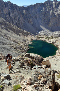
The trail is fairly flat from here till the next two junctions (mile 4.8, RO08 Junc GoLeft and mile 5, RO09 JuncGoLeft). Take a left on both. The first one abandons the PCT. The second one needs special attention since the sign to go to the Onion Valley is only visible if you were walking in the other direction. From here, the trail has a combination of steep and flat stretches that will take you to the Kearsarge Pass. On the way you’ll have wonderful views of the Bullfrog and Kearsarge Lakes as well as the razor sharp crests. The last few switchbacks before the pass (mile 7.6, RO16 KearsargePass), are quite mellow which allows you enjoying the last vistas of the park.
 The 4 miles down to the Onion Valley Campground offer a variety in vegetation:
from barren rock at the very top of the pass to sparse pine trees, shrubs and
more dense forests to the cottonwoods by the campground.
Probably the best view of the entire way down is when you approach the Gilbert
Lake (mile 9.7, RO22 GilbertLakePic). The illusion of the lake
waters spilling over a cliff could have been the inspiration for the pools at
the luxurious touristic resorts. The trail zigzags its way down to the parking
lot (mile 11.9, Parking lot) where you meet civilization. Now
you’ll have to drive north on the 395 to get to the other car and drive home.
The 4 miles down to the Onion Valley Campground offer a variety in vegetation:
from barren rock at the very top of the pass to sparse pine trees, shrubs and
more dense forests to the cottonwoods by the campground.
Probably the best view of the entire way down is when you approach the Gilbert
Lake (mile 9.7, RO22 GilbertLakePic). The illusion of the lake
waters spilling over a cliff could have been the inspiration for the pools at
the luxurious touristic resorts. The trail zigzags its way down to the parking
lot (mile 11.9, Parking lot) where you meet civilization. Now
you’ll have to drive north on the 395 to get to the other car and drive home.
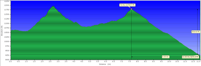
Profile from Rae Lakes to Onion Valley Campground.