• Logbook
• Road Stars
Photo album:
• Lanín NP
Download GPS files for Lanín NP:
• GPS track & waypoints


At the end of the previous stage we crossed the border between the Nahuel Huapi and Lanín National Parks. In this brief 2-day story we tell how we crossed the Lanín N. P. to reach the border with Chile.
Stage index:
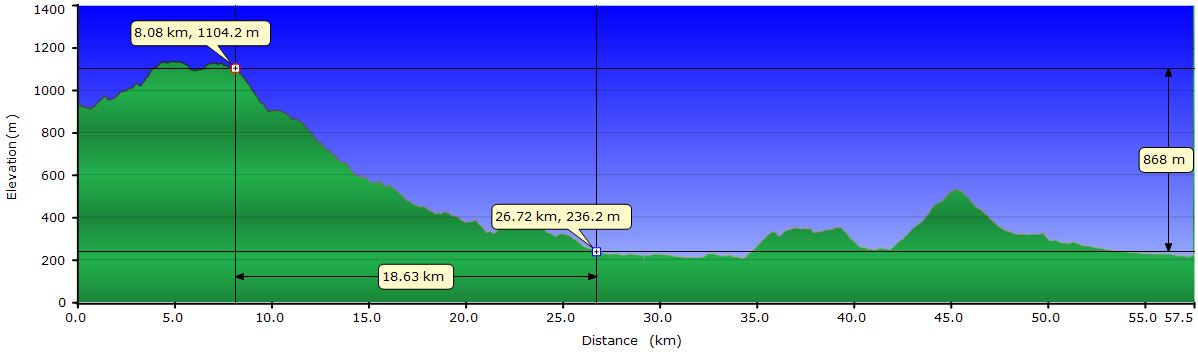
Abril 18: From San Martin de los Andes to Lahuen Co hot springs (Profile)
Abril 19: From Lahuen Co hot springs to Coñaripe (Profile)
April 18, 2011: From San Martin de los Andes to Lahuen Co hot springs
 We leave San Martín toward Junín de los Andes. After a few miles, we leave the pavement and take a dirt road that will take us to Lake Lolog. The first switchbacks on this road are brutal, but once overcome, we ride quickly thanks to the condition of the road and the gentle climbs. The road runs along part of the lake and then turns northeast to give way to drier scenery. In this area of steppe, most of the land is cleared of trees. The only small forests we see are on the river banks. After a few miles the road turns 90 degrees to go directly towards the Andes range. In this second part of today's itinerary we see a progression toward rainforest, leaving behind the steppe. When we get to Lake Curruhué Chico the landscape begins to be alpine with snow-capped peaks all around. But when we arrive at Lake Curruhué is when we realize that we are already in the heart of the Andes. The lake is very narrow and elongated, following the valley formed by parallel ridges on both sides. The forests are dense and gradually becoming more and more humid. The ferns and bamboo are more abundant now. Fortunately, today we have a gorgeous day and we can enjoy all this exuberance without getting wet.
 At the beginning of Lake Curruhué there is a small forest of Araucaria, a symbolic tree in the area. Some individuals live more than 1000 years and they have a prehistoric appearance. And there is a good reason for that, as they already existed before South America, Africa, Antarctica, India and Madagascar split from the supercontinent Gondwana some hundreds of millions of years ago.
 The road that surrounds this lake is a joy on a day like today. Most of the time, you ride under a blanket of vegetation that surrounds you everywhere. The forest is so lush that if you look up you cannot see the sky. You see different shades of green, from the darkest on the branches closest to you to a bright green on the canopy where they are illuminated directly by the sun. From time to time the forest open up to our right letting us see the lake and the hillside on the opposite shore, equally dense. The road to the border surrounds a series of lakes and ponds. After Lake Curruhué comes the Laguna Verde and after switching to a different valley we run into Lake Epulafquen. A curiosity here is the 4000 year old river of lava from a nearby volcano that reaches its shore. The place is surreal. After passing through miles and miles of forest without seeing the sun, here we have this natural firebreak that splits the forest in two by a rugged terrain of sharp volcanic rocks, that the vegetation hasn´t been able to win back since the eruption.

Our intention is to camp before the border pass to attack it tomorrow. However, all the camping areas are behind and at the ranger office there is nobody to ask. A few hundred yards farther are the Lahuen Co hot springs and we go there to ask if they let us pitch the tent on their land. As we expected, they don´t and remind us that it is forbidden to camp outside designated areas. In other words, the only option we have is to sleep on the hot spring accommodations despite the high price. Gustavo and Sara try to convince us to stay, explaining all the features the center offers and in the end they succeed with the cheaper alternative. In short, we are forced to bathe in the outdoor pool with sulfuric water around 100 degrees while the sun sets behind the Andes, put on a bathrobe after the shower and sleep in a comfortable bed with down comforter in a warm room . Ah! And check email via Wi-Fi in the restaurant in the middle of the Andes! Well, not bad way to finish the day.
April 19, 2011: From Lahuen Co hot springs to Coñaripe

 The breakfast Ana María prepares is simply spectacular. She prepares everything based on mom recipes from oatmeal cookies and apple pie to yogurt and jams. And of course the bread, those warm toasts she keeps bringing. I think she sees us hungry and knows the climb we have today to the border pass. The couple of Uruguayans who shares breakfast with us take food from the buffet 2 times at most. We do more trips to the buffet. To be honest I should say many more. I hope that neither Sara nor Ana María counted them... With our stomachs completely filled up, we set off and except for a couple of short hills; the stretch to the border is easy. The foliage of the forest blocks all views, but in a more clear area, between branches we can see the Lanín volcano.
 The descent from the pass to the village of Liquiñe is fantastic. At first, the track is bad and we cannot ride too fast since the rack suffers under the weight of the panniers. From the border police checkpoint where we formalize the entrance to Chile, the road improves substantially. In addition, the SAG inspector (food and animals imports) helps us to move weight from the panniers to our stomachs. Since yesterday we had dinner at the hot springs restaurant, we didn’t eat the avocados, carrots, apples, and cheese that we had planned for dinner. None of these products can be entered into Chile so we have two options: either he will confiscate everything or we eat it all. It’s just over noon, perfect time to sit in the sun on the steps of the checkpoint office and enjoy a meal much more generous than usual. We believe that the inspector was interested in our cheese, but the whole pound is now in our stomachs. With the last bite still in our cheeks, we rush down the road with extra energy we won’t need for many miles.
 After about 10 mi of uninterrupted downhill, the brakes are almost melting. The overview on the Chilean side is not comparable to the Argentine one. The valley we ride along is pretty narrow and the mountains block any view of the surrounding volcanoes. It opens up only when you reach Liquiñe but by then the sky is gray and now the clouds prevent us from seeing the volcanoes Villarrica and Quetrupillán. We are now on the other side of the Andes and you know, it rains almost every day here and today is not going to be different. The road after Liquiñe is under maintenance and has plenty of loose rocks which become a pain in the butt. Literally. Fortunately the last miles to Coñaripe are paved.
Today we wanted to get to the hot springs on the hillside of the Villarrica, about 9 mi from Coñaripe. Although we know we will not arrive there before dark, we start climbing. After about 2 miles the rain intensifies and we turn back to town and seek a place to stay. The owner helps us to organize a transport to take us to the hot springs tomorrow morning. Is not that we are lazy, a big storm is coming in a couple of days and tomorrow we have to get to Pucón to avoid it. But that is part of the next story.