• Logbook
• Road Stars
Photo album:
• Nahuel Huapi NP
Download GPS files for Nahuel Huapi NP:
• GPS track & waypoints (hike)
• GPS track & waypoints (ride)
Lodging and eating:
• Hostel La Justina (Bariloche)
• Hostel Rukalhue (San Martín)
Bike shop:
• BikeWay (Bariloche)


During this stage of the trip we visit the Parque Nacional Nahuel Huapi in 2 ways. First on foot, in the area around Bariloche. Then cycling the 7 Lakes circuit to the border of Chile, where the next chapter starts.
Stage index:
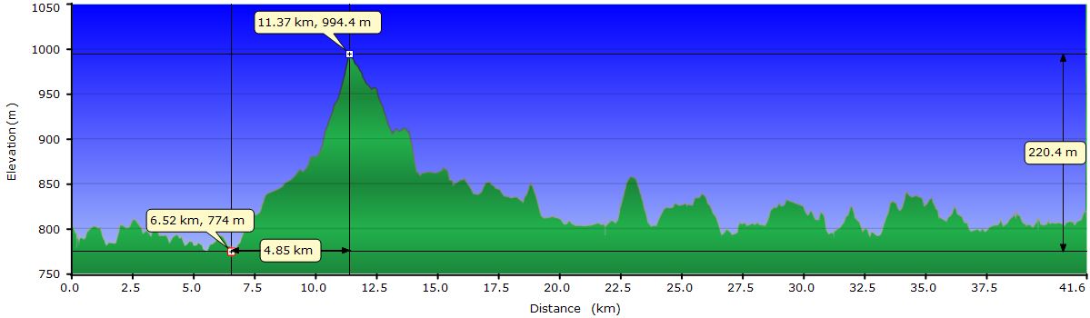
Abril 8: From Villa Catedral to Campamento Rucaco (Profile)
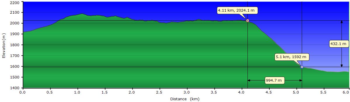
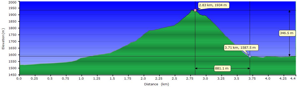
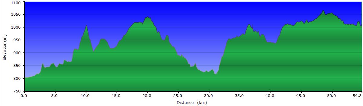
Abril 9: From Campamento Rucaco to Refugio Jakob (Profile 1st part) (Profile 2nd part)
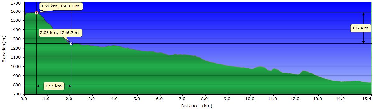
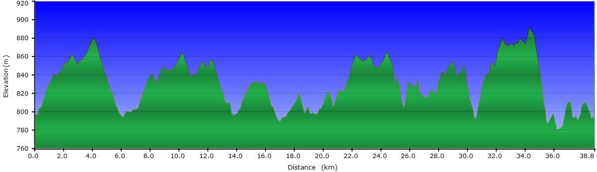
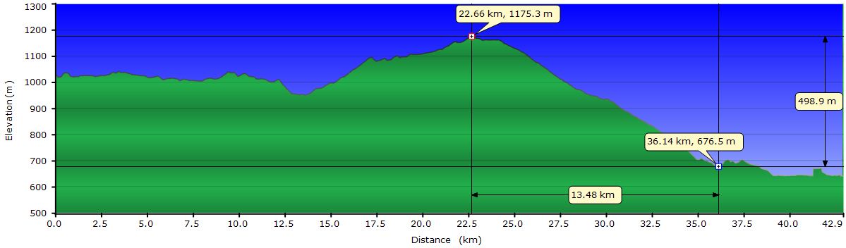
Abril 10: From Refugio Jakob to Bariloche (Profile)
Abril 11: From Bariloche to camping La Estacada (Profile)
Abril 12: From camping La Estacada to Lago Espejo Chico (Profile)
Abril 13: From Lago Espejo Chico to Villa Traful (Profile)
Abril 14: From Villa Traful to camping Los Arrayanes (Profile)
Abril 15: From camping Los Arrayanes to Lago Hermoso (Profile)
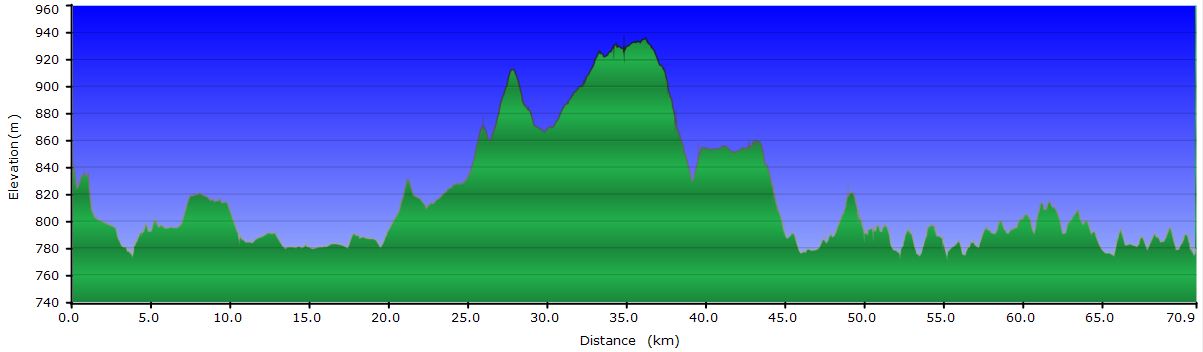
Abril 16: From Lago Hermoso to San Martín de los Andes (Profile)
April 8, 2011: From Cerro Catedral to Rucaco camp

Our hike starts at the ski slopes of Cerro Catedral. After getting there by bus, there are two options to start the walk: get on one of the gondolas to the refugio Lynch or be a macho and ascend on foot from the base (and save a few bucks). We are not that machos.
 The trail starts at the refuge Lynch, climbs to the crest of the ridge and follows it until it is too steep. Then skirts by a scree where you often have to use your hands to overcome a difficult stretch. Well above the vegetation line, we have uninterrupted views. The scenery is dominated by Cerro Tronador, which is more than 3000 feet higher than any of its neighbors and the only one that preserves snow from last winter. Down in the valley, the slopes covered by lenga forest are starting to change colors with the arrival of autumn.
 The first day of the standard circuit ends at the Refugio Frey, but we decided to skip that part and when we got to the turnoff for the shelter, we followed the trail to the campground down at the valley. The way down is a merciless downhill through a scree in which marks are seen only in the larger granite blocks. There is no official trail, since the steep slope and all the loose rocks make it impossible to keep one. Simply everyone makes its own way generally following the line of maximum slope. At every step, the heels sink into the dirt and slide down a few inches, speeding up our pace. When we get to the tree line, where the terrain is more stable, the trail takes advantage of the dry bed of a stream to break through the forest and get to the bottom of the valley. Crossing the forest is a delightful experience. Each corner has a different leaf color. From the green that was everywhere until a couple of weeks ago, to the yellow of the most advanced in the process of falling through a deep red and all hues in between.
 We arrive at the camp by the Rucaco River, pinch the tent one hour before sundown and sit on a stump in the meadow outside the thick forest to enjoy the last rays of sun and the spectacle of both the colors of the vegetation and the sharp towers up on the edge of the ridge we just downclimbed.
April 9, 2011: From camp Rucaco to Refugio San Martín
 The first stretch of the trail to the Refugio San Martin goes in and out of the forest several times to give us the opportunity to see the two landscapes, the tall lengas still green and the shorter ones in the river plain with red leaves.
 The climb up the hill to the Brecha Negra (Black Gap) only has a short steep stretch, so it's easy to get to it. The view from here is the best of the entire hike. At the bottom of the valley is the Laguna Jakob and the San Martín shelter at its shoreline, surrounded by reddish and yellow forests. As a backdrop the snowy peaks of the range. Spots of vegetation of different colors alternate along the Casa de Piedra River Valley.
Like yesterday, the downclimb is crazy, just straight towards a dry stream that eventually goes into the woods and runs along a normal trail. As we descend we can enjoy from different angles the spectacular frame of the lake and the reflection of the peaks in its calm waters. When we reach the lake we take a moment to absorb the peace and beauty of the place.
 Today's hike was very short, so on the afternoon we go to the Laguna de los Témpanos. Although the glacial cirque in which it is encased has imposing walls, the orientation of the sun keeps it in the shade and loses its appeal. We also get to the bottom of the gully used to go from the San Martin shelter to Segre shelter. Both at the Club Andino Bariloche and others we've talked, discouraged us from climbing the gully. The truth is that from the entrance it looks very accessible. There is an exposed stretch of about 150 feet but with solid rock and good spots to scramble up even with a backpack. Perhaps it’s dangerous with windy conditions or wet rock. Nevertheless, we prefer not to change our route and finish the trip tomorrow instead of going to the other shelters. The main reason is that in the Refugio San Martín we have seen photos of the way to the Refugio Segre and there is no vegetation. In contrast, the way to the road through the valley in which we are, looks very promising going through the woods.

April 10, 2011: From the San Martin shelter to Bariloche
 The descent through the valley of the River Casa de Piedra has a couple of features that make it worthwhile. The first is the existence of bamboo mixed with lengas. We never thought bamboo would be found more than 3000 feet above sea level in these latitudes. The path alternates stretches of tall trees stained with the autumn hues with thick walls of bamboo at both sides. The other peculiarity of this hike only happens at this particular time of the year. Perhaps it is not magic for others but for us walking through the forest under a rain of golden leaves when the wind shakes them off their branches is unforgettable.
 The last stretch to reach the road has no special interest. Once at the road, since the tourist season is over, the buses often passing through here in summer are no longer operational. We have no other choice but to walk to another more important road about 3 mi, serviced by buses regularly throughout the year. We hitchhike and after only 1 mi a lovely couple picks us up. They have gone out for a ride and are going back to Bariloche. We're lucky: they take us to the door of the hostel where we are staying. Along the way we chat about various topics and they give us explanations of the places we are going through. It catches our attention their perspective of the recent global crisis. They are so used to the Argentine economic rollercoaster, that this is just one more, with far less significance compare to the effect in other countries.
Back at the hostel La Justina, highly recommended, both for the kindness of the girls who carry it and the common area facilities, we dedicate some time to prepare the bike ride for the next days. The weather forecast is pretty grim, rain and cold for the next 5 or 6 days. Didn’t we escape the South of Chile because of the rain?
April 11, 2011: From Bariloche to Camping La Estacada
Loaded with all our bags including the box we self-ship and with our stomachs filled with the hearty breakfast, we jump into Bariloche’s traffic to leave the town as quickly as possible. Just after a few yards, Judit notices that the rear wheel rubs the frame. We look at it and conclude that we have to take it to the bike shop. The diagnosis from the competent mechanic at BikeWay is that it has a broken spoke on the sprockets’ side, so the repair includes removing the cassette and the brake disc to install the new spoke and retrue the wheel. While he does the job, we have a coffee and a smoothie to supplement the diet before we start pedaling.
 With the mechanical problems fixed we head to the bus company cargo terminal that will carry our box to Neuquén. To get rid of the 18 lb box is a pleasure as well to move the backpack from my back to the rack. The ride out of Bariloche, like any city is bad, not only for the risk of traffic, but also for the fumes you breathe. Argentines in general do not show much respect for cyclists and the first miles are stressful. Luckily we go fast, as Judit goes ahead and sets a strong pace to get away urgently. At least it’s not windy or raining ... yet.
 When we reach the eastern end of Lake Nahuel Huapi, we take the road to Villa La Angostura and the traffic gets reduced considerably. Much of the road goes by the shore of the lake and despite the cloudy day, we love the ride. The Huemul arm Peninsula and Victoria Island offer great views across the water. Miles pass quickly thanks to the smooth asphalt and the gentleness of the undulations of the road. Within 5 hours we get to the campground. It’s deserted and we settle on a site next to a small beach where, once again, I lose a spoon while fishing. This is becoming a ruin. Besides the money we spend to buy more gear, every morning I find it harder to carry the olive oil bottle to fry the trout. It's been weeks that we are carrying it...
April 12, 2011: From La Estacada campground to Lake Espejo Chico
It´s been raining most of the night and still is when we wake up, so we stay inside the warm sleeping bags. What a pleasure not having to meet schedules or timetables! An hour later we have breakfast and when we see a bit of blue sky, we pick up the camp at full speed and set off. The truth is that leaving the tent and start pedaling is much worse when it rains. Much harder than if it starts raining when you are rolling.
The weather respects us until Villa La Angostura, where we stop to buy food for 3 or 4 days and have a coffee and a banana shake accompanied by a cake. Villa La Angostura is not terribly interesting. For several miles before and several after the road is a series of ads for hotels, lodges and restaurants. The ski slopes of Cerro Bayo and all the related services reminds us of Andorra in the winter season.
The latest views of Lake Nahuel Huapi are the best: small islands and inlets of vertical walls with vegetation to the edge of the tiny beaches. We cross the bridge over the River Correntoso, the world’s shortest according to the sign. From the bridge, to the right is the lake Correntoso, where the river is born. To the left it meets the Lake Nahuel Huapi, where it ends. In total, less than 100 yards. After a few miles we fork to the road that will take us to the 7 Lakes Circuit. We first skirt Lago Espejo but the rain, which has been threatening us, has finally begun to fall and doesn’t let us enjoy it as we wished. Also, the asphalt is gone and it’s harder to ride on the wet dirt. Still, the road is very nice and we take advantage of the few sections where the vegetation opens up to take pictures. In addition to the main lakes, the road surrounds several smaller lakes worth of a postcard on a sunny day.
It’s been raining hard for a while when we arrive to Lago Espejo Chico. During the last few miles we followed the game of putting on and taking off our waterproof gear several times. We don’t fully understand the game, but it seems that in order to stop raining you have to wear the rain jacket and pants, but nevertheless, when you take them off it starts raining again. I think we must find the game rules to avoid getting soaked every day. Oh well! The small shack at the Lago Espejo Chico campground provides us shelter at the end of the day. While waiting in vain for the rain to stop to pitch the tent, we take a shower, eat, and check a few spots to camp. The manager suggested that we put the tent under a roof next to car parking. We reject the idea in search of a place near the lake under the trees that protect us at least indirectly from the rain. Tomorrow we will realize of our mistake.
The manager once again encourages me to try my luck with the trouts. According to him, with the rain river’s flow increase and trouts move from one lake to another in search of their places of birth to spawn. He also sells the special spoon for the area. I cannot resist the temptation and even it's still raining I assemble the rod and go to the river bank. To add to my frustration, I realize that the spoon that I lost yesterday, also took a good piece of fishing line. I feel stupid when I cast and there are only a few yards of line left. I'm wet, my hands are cold and it’s getting dark. I got back to the test pissed off. Judit has everything tidy and ready in the tent to spend another night in the rain. Let's see if we can keep it outside because this night is going to rain cats and dogs.
April 13, 2011: From Lago Espejo Chico to Villa Traful
It has been raining all night and continues throughout the morning. After lingering for a while in the sleeping bag, as the bladders have a limit of expansion, at the end you have to confront to the outside world. The weather makes pedaling very unappealing but staying doesn’t have any advantage either. Back from the bathroom, we go to the reception. When we get under the porch, an old guy wearing a hood whistles from the door of his cabin making gestures like saying “don’t do it”. What? As we do not understand anything we try to open the door, but it is closed. Then we look towards the hoody and see how it hides a machete in his coat pocket and walks toward us. Clearly the knife protrudes about a foot from his pocket, but he conceals it with his forearm. He takes shelter under the porch and informs us that the owner will not return until later in the evening and therefore the reception is closed. Without losing sight of the machete, we start a conversation. He seems to trust us and invites us to his cabin. To be honest, we do not know if that's a good idea. Perhaps he will dice and slice us there. Perhaps the owner is also there already sliced. It turns out he is the responsible for the maintenance of the campground. Hector is a guy that doesn’t trust anybody and has somewhat bizarre ideas so we dry the rain jackets and pants in his kitchen and go to pack everything and get out of here as soon as possible, given the specimen that inhabit the place.
Although it has stopped raining, the road is full of puddles. However, argentine drivers don’t slow down compared to yesterday. In fact, they have no respect for us and we have to calculate the meeting point so that there are no puddles around to avoid the splash. Yup, we do have a very clear complaint against argentine drivers. The trick to block the road will not work because it is too wide.
 Today we want to arrive to Villa Traful, on the shores of Lake Traful. Although this lake is not part of the 7 lakes circuit, according to the guide, the site of the village is charming. The diversion of the main route begins with the climb of Portezuelo pass. Near the peak, slightly above 1000 m, there is still fresh snow from yesterday. During the descent the cold is especially noticeable in our hands and feet, but at least it only rains some and from time to time. Sometimes with enough intensity to make us put on our rain pants. When it stops we remove them to avoid the extra effort to pedal with them on. Along the way we play the put on/take off game for hours.
The forest covers both sides of the road and often reaches over the road itself. When it opens up, we see that all peaks are completely covered by the snow. The landscape, though gray is beautiful, especially when we reach Lake Traful and follow the coast to the Villa. The ground is completely soaked and in some areas the mud and the softened dirt hamper our progress. However, the wind blows from behind and compensates in part.
When we arrive at Villa Traful, it begins to get dark. We wanted to sleep in a shelter because the tent is wet, but practically all accommodations have closed for the season. The only thing left open is being rented by the village school while their building is being repaired. The only possibility is to camp or pay for a cabin at high season price. Finally we pitch the tent in a campground quincho, a shelter from the rain. Although today’s ride was short, the rain and cold has kept us on the edge for hours. As always in these cases, the first thing we do after getting into the tent is to prepare a hot tea while we put on dry clothes.
April 14, 2011: From Villa Traful to Puerto Arrayanes
Normally we wake up with the sound of rain on the tent or the singing of birds, but today is the sound of children entering school in the building right next to our tent. Today is still cold so we begin our routine of preparing breakfast from inside the tent under the curios eyes of the students. We believe that once they enter the classroom, the teacher changes the topic of the day for a practical anthropology class. He tells his students how native Indians in the area protected themselves from the weather getting under cover in tents made of animal skins held by sticks laid crosswise. They slept over branches and skins to reduce soil moisture. He explains they knew the fire and used it both to warm them up and to cook their meals. They spoke a strange language (Catalan in our case) until the colonizers imposed Spanish. They used tools such as fish bones to groom their hair and smeared with ointments to protect against severe weather. Sure students are spying on us from behind the curtains. At one point, and only focusing on education, I am tempted to get out of the tent bare-chested and beat my pectorals with my fists gorilla style but Judit doesn’t let me do it. When it's playtime, we're cleaning and lubing the bikes. When the most curious ones approach, we speak in Spanish to them destroying all the primitive man scenes they had imagined during class.

Finally, we set off to ride back to the main road, but after traveling the 9 miles of the lake’s coast we arrive at Camp Los Arrayanes, on the western end of the lake and decide to stay there to spend the rest of day. The sun shines and we have lunch at the beach but after a few minutes it starts raining again. We spend the rest of the afternoon locked in the tent. Late in the evening I go fishing. At least this time the trouts bite a couple times but unfortunately not enough to get caught. After the initial pull, I see them jumping out of the water, shaking their tail. I’m not sure wheter because of the painful sting of the hook or because they are making fun of me.
April 15, 2011: From Puerto Arrayanes to Lago Hermoso
Today the sky is partially covered but the clouds do not look threatening like in recent days. The low temperatures, however, continue. According to the campsite manager, the temperature is 40 degrees, and it's already 10 am.
After climbing back the Portezuelo pass, we join the main road to ride the last miles of mud and puddles. I cannot control myself and more than one driver takes my worst bad words in several languages. One honks at us nervously as we pass a construction truck stopped at the right margin.
 In this area the vegetation is somewhat less dense and allows us to better see the valleys through which we are passing, as well as the mountains and rivers that form them. We're used to the crystal waters we have been drinking for several days. Maybe that's why we no longer appreciate them enough. The sky is clearing up gradually until only a few white innocent clouds remain. It is surprising how the perception of the environment changes when the sun warms the body and illuminates the trees. On one side we are more receptive to the environment, more willing to appreciate it. On the other one, the bright colors of the leaves and reflections in the water of the streams replace the gray tones that have been accompanying us during the last days.
Around noon we reach the paved area of the road. From the top of a lookout we eat contemplating the thin spit of land separating the lakes Villarino and Falker through which the route runs and all the surrounding snow-capped peaks. The day is calm, no wind. The water sparkles in the sun. At the end we can enjoy the 7 lakes circuit. A few miles farther we leave the Nahuel Huapi National Park to enter the Lanin National Park. Both protect this wonderful section of the Andes.

When we reach the Lake Hermoso campground, we find out it’s closed during the winter season. We are too far from any other authorized camping area, so we sneack through a hole in the fence. In this valley the wind brings the cold from the snow of the mountains. As the sun goes down behind the ridge, it's time to get home.
April 16, 2011: From Lake Hermoso to San Martin de los Andes

A cold mist floats on the lake when we get up. When we get out of the tent, the frost on the door crackles. The cold weather has caught us again. As if we were fugitives, we cross the fence of the campground through the same hole we used yesterday and we set off in silence. When we reach the road we have to stop for a while on a sunny spot to warm up our fingers that froze while packing the bikes.

To the West we see conical peaks that are likely to be volcanoes. This area of the range is known for the many active volcanoes like the Lanin, Villarrica, Llaima, etc. Slowly the mist is fading and the sun warms us up pleasantly, so we resume the ride. In the small pass we have to overcome to get to San Martin de los Andes, the frost has not yet melt on the shoulders of the curves in the shade. In some areas we find a phenomenon we have  never seen before and which the locals call the nail frost. It is a cluster of ice filaments about 2 inches long that grow parallel to each other but without touching. Often, the end of each one is crowned by a tiny pebble. It seems that during the night or early morning, water or moisture under each of the gravel was frozen, with a consequent increase in volume, and the lifting of a thousandth. The process keeps on going while the temperature is low enough and makes the filament grow and lift the gravel in its crystalline tower. The filaments are not straight but wavy, but all follow the same direction within their group and don’t make contact. With the warmth of the fingers they melt immediately and the gravel falls from its ice pedestal to the ground. When the first rays of sun begin to illuminate the slope of the ditch we see tiny avalanches of gravel.
The top of the pass is marked by the Arroyo Partido (Split Creek). It splits into two streams at this point. One flows into the Pacific Ocean while the other travels to the Atlantic. From this point, the road descends steadily until San Martín. The last section runs parallel to Lake Lácar, to a certain height of water offering a good view of the town.

San Martin today is bustling due to the celebration of a sport event. The runners of the 10 km race are just reaching the finish line as we enter a restaurant to delight us with a deer stew. Upon leaving the restaurant, the first to complete the marathon arrive at the finish line. When it is completely dark, and despite the rain the survivors of the 84 km race reach the line while the public encourage them in the last yards to the finish. 84 km! Everyone deserves the prize.