• Logbook
• Road Stars
Photo album:
• From Humahuaca to Calilegua NP
Lodging and eating:
• Hospedaje Portal de las Yungas (03887) 462001 (Santa Ana)
• Tía Carola Restaurant (San Francisco)
Download GPS files for Quebrada de Humahuaca:
• GPS track & waypoints


On most maps of the area there is no connection between Humahuaca and the Calilegua National Park. The truth is that there is a track for vehicles from Humahuaca to Santa Ana and another between the park and Valle Colorado, but between Santa Ana and Valle Colorado there is no road for cars. And no wonder, because the terrain makes it almost impossible to build one. However, the Incas did have their way to get from the Andean highlands to the Yungas. Today, villagers still use some of it to move around. We pedaled through the vehicle tracks and push the bikes along the Inca and other trails on the edge of a cliff to complete a journey through various natural ecosystems, different indigenous groups and a series of experiences not easily forgotten. Here is the story of this journey.
Stage index:
June 29, 2011: From Humahuaca to Cianzo (Profile)
June 30, 2011: From Cianzo to 14500 feet (Profile)
July 1, 2011: From 14500 feet to Santa Ana (Profile)
July 2, 2011: From Santa Ana to Valle Grande (From the Puna to the Yungas) (Profile)
July 3, 2011: From Valle Grande to San Francisco (Profile)
July 4, 2011: From San Francisco to Calilegua National Park (Profile)
July 5, 2011: From Calilegua National Park to Jujuy (Profile)
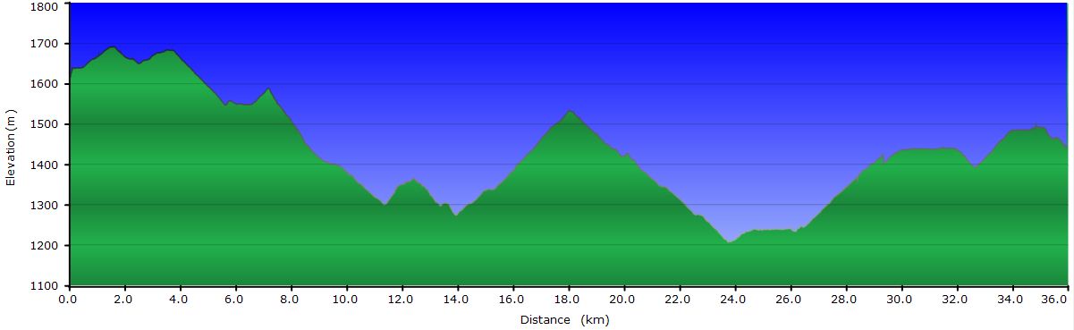
Profile for the entire stage:

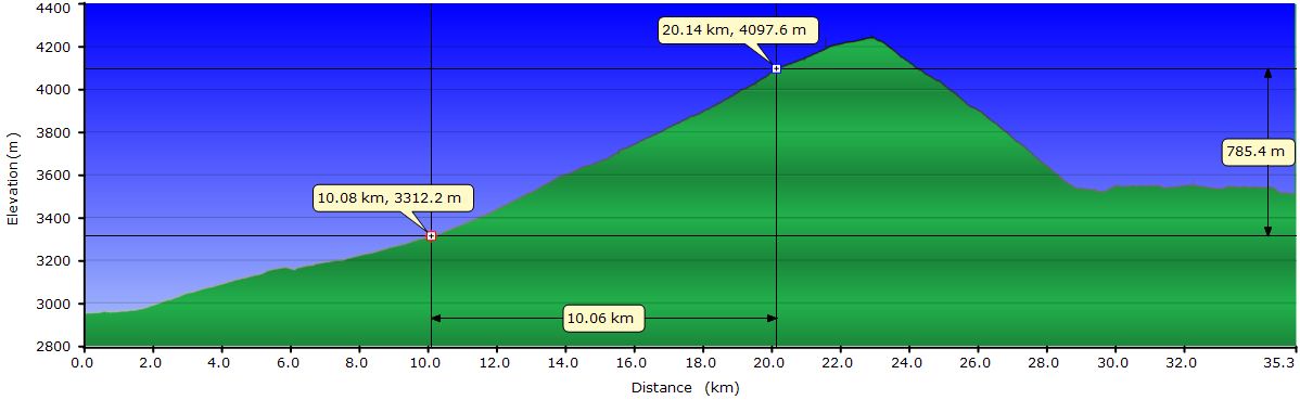
June 29, 2011: From Humahuaca to Cianzo
 The dirt road from Humahuaca to Cianzo begins with a gentle slope for the first 2 miles. From here and until mile 6, the slope increases but is not a big problem. The terrain is acceptable, a mixture of loose rocks and mild serrucho we can avoid in most cases. The route consists of long straight stretches pointing to the range we have to cross. At the foot of the mountains we find the last houses we will see in a couple of days. Most of them seem abandoned, but some have chickens and donkeys nearby.
At mile 6 the slope increases to an 8% and continues so until mile 12.5. As if the slope was not enough, the elevation puts our endurance to test. Today we started at 10000 feet and the pass before us is at 14000 feet. We’ve been riding one behind the other without speaking for a while now. We can’t skip a breath. Beyond the 12500 feet, the breaks become more frequent. Fortunately, the terrain is now more compact, probably because here the vehicles run more slowly due to the slope and the lack of oxygen for the engine combustion. From time to time a truck passes us crawling uphill.
 There is not a single cloud in the sky and the sun warms us through our black clothes. A light west wind blows which, although cold, pushes us up in bursts. The temperature is low. We don’t know exactly how cold it is, but the only stream that crosses the track is frozen. And it's 3 PM. The 180-degree switchbacks are linked back to back endlessly, but each one we overcome means there is one less ahead. Half way up, a herd of vicuñas crosses the track. So far we had only seen 2 of the 4 existing camelids in South America, llamas and guanacos. Vicuñas are somewhat smaller in size and are easily distinguished from the previous by the slender neck. They go away from us uphill, jumping as if that didn´t involve any effort. We, lowland humans, have a moderate headache and occasional mild dizziness when we move the head rapidly due to the altitude.
 At mile 12.5, the slope levels out a bit and 2 miles later we reach the pass. Here we deviate from the road used by the vehicles and ride down the other side of the mountain on a 4WD track that leads directly to Cianzo. The descent is a blast. The track is in pretty good condition and the slope is 12%, so we lose altitude quickly. As we approach the valley floor, our angle of view widens and the village of Cianzo appears in sight beside the river, surrounded by pastures. It’s located behind a half gray half red hill. Across the valley and further south a succession of near-vertical layers of different colors show up. This is the Serranía del Hornocal. The structure is similar to the one we saw last week at Maimará, but this is much bigger and more beautiful. One of the summits seems to have split in half, exposing a thin stack of white and red sediments. Above all these earthly features, a saturated blue sky rounds up the scene.

At Cianzo, we refill the water bottles at a private home and continue in search of a campsite. A few miles from town we find a suitable location by the river bank and outside the fences enclosing the fields and pastures. It is a small space surrounded by bushes but enough for our tent. A few yards away there is a shepherd with his flock of sheep. We set up the tent and approach him to make sure we are not bothering him. The man is a sullen and moody type that barely responds to our greeting. It is true that we have already set up the tent, but it´s outside his field. His only comment beyond a grunt is: “I´ll be back later to burn it all”. And with no further reasoning, he goes away with his herd. The sun has already set behind the ridge and the cold is really biting us now. There we stay not knowing what to do. At the end we decide to pick up the tent, but don´t know whether to go back to Cianzo or ride ahead far away enough from the arsonist of the valley. A minute later, a local riding a bicycle passes by towards the village. We intercept him and explain what just happened and he suggests we ask for permission to sleep in the school at the village. It seems a perfect alternative and the three of us pedal back to Cianzo. Once at the school, everything becomes easy as they allow us to set up the tent in a room. Tonight we sleep under 2 roofs and away from the crazy old man. The only little problem is that students arrive tomorrow around 8:15 and by then we have to be out. Out probably means outside. We don´t think the sun will be high enough to reach the valley by then. The teachers make sure we know it´s going to be a cold night. To make sure we understand, they show us how stiff the clothes drying on a string are. The frozen sleeves refuse to follow the law of gravity. Anyway, for us is a great solution compared with being charred at midnight.
June 30, 2011: From Cianzo to 14500 feet
Today we get up earlier than usual, as the children enter the school about 8:15. When the first ones show up we have everything cleared out, but the bikes spark their curiosity. However, they are too shy to ask. While chatting with some of the teachers the sun line on the western slopes of the valley keeps going down. The school has 50 students and 7 teachers, some of them for special subjects such as agricultural techniques, music and visual arts. At 9 am they all hoist the flag while singing the national anthem. After that, we take some pictures, say goodbye and set off.
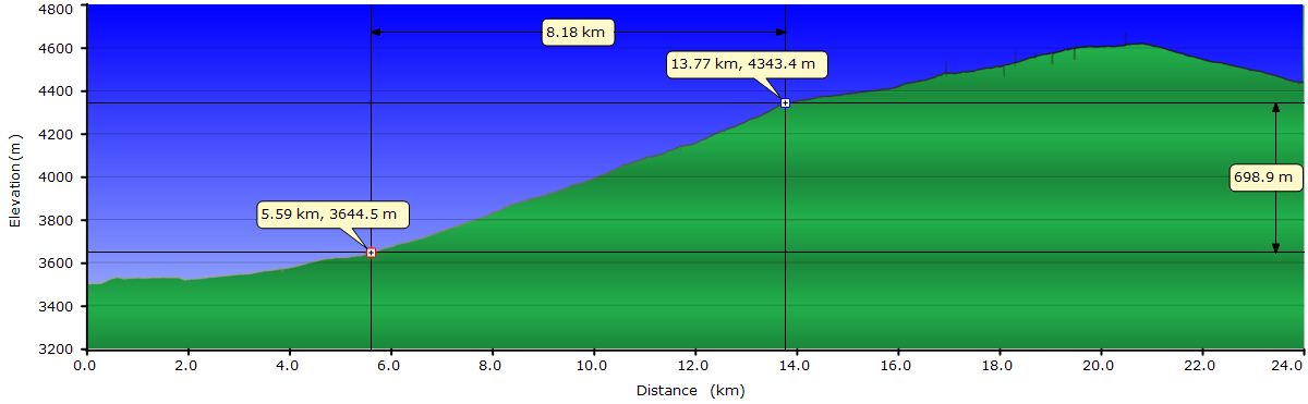
 The areas of the river where the water flows slowly are frozen. In fact we have to go through a couple of tributaries with a thick layer of ice. Fortunately, a vehicle has already forded the creeks and broken the ice, leaving ruts we use to cross. Up to mile 4, the slope is acceptable, despite the poor condition of the track. From that point and for the next 5 mi, the effort is considerable, given that we are above 12000 feet of altitude. The last miles up to mile 9 are really hard, mainly because of the slope (above 10%) and the rocks that slow us down and make difficult to keep balance at such low speed. In this section we have to push the bikes several times. By now, the Abra de Zenta, the pass we have to cross, is on sight. On the other side of the valley we see an infinite road going up but at a gentler slope. In this area we find a villager with his dog and 3 donkeys. When we get close, he moves away from the road but when we say Hi, he comes back to shake our hands. The skin of his hands is crisscrossed with cracks filled with road dust, his lips and teeth blackened due to coca chewing (the consumption of coca is legal in the provinces of Jujuy and Salta, Argentina). We chat for a while before moving on. At the end of the valley we cross to the other side where the terrain greatly improves and we can move faster.

 Getting to the Abra de Zenta pass (14700 feet) is an achievement by itself, but we know that even being a pass, is not the end of our climb. The track keeps ascending to the right, up to 15160 feet at mile 13 from Cianzo. Once we get to the true pass, we rush down the track into a valley that seems to have no exit but after a few zigzags we see it. The road then climbs back up to the same elevation of the last pass. This section was unknown to us because the GPS map we have has a blank in this area. When we reach an area more or less flat, we pitch the tent. We are not up to climb a second pass and it’s already 4 PM. While sleeping at 14500 is not our dream, we prefer that to suffer the second climb and having to go down in the shade on the other side, not knowing if we will find somewhere to camp. Also, here there is a stream to replenish water. Well, we’ll have to crack the 2 inch thick ice to find it... Anyway, we set up camp just before the sun sets behind the mountains and take refuge inside the tent quickly. Tonight is going to be chilly.
July 1, 2011: From 14500 feet to Santa Ana
 Yeah, last night was a little bit cold. Just a little bit. This morning the water we had inside the tent was frozen... During the night, only our feet were cold though. It has been proven that sleeping with 2 sweaters, a fleece, two pants, a beanie and gloves inside the sleeping bag is sufficient. It seems that two pairs of socks and a towel that Judith wrapped around her feet are not enough. I guess the insomnia I had tonight was due to the altitude. I've finally found a remedy to fight my ease falling asleep. Not very practical though. We stay inside the sleeping bag until the sun starts to warm up the tent, no matter how bad the pressure on our bladders is. The water for breakfast takes forever to boil. Outside it's as cold as hell.
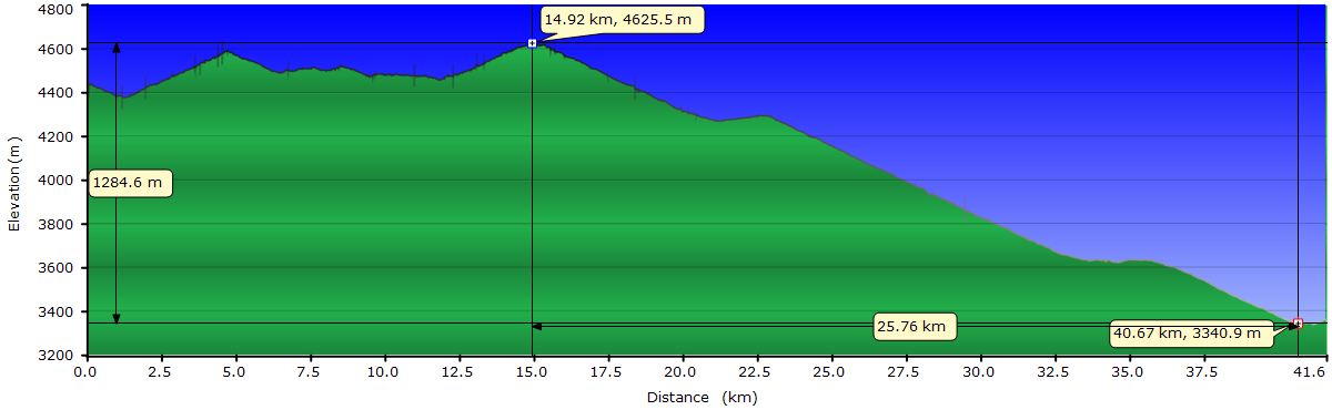
The wind has been blowing all night and still continues. At 11:30 we're ready to get back on the road and resume our route. Although the temperature doesn’t feel that low in the sun, the wind is biting cold. Supposedly, all of Argentina is affected by a polar front. The strange thing is that here the wind comes predominantly from the North. Today we start going down the dirt road about 600 feet to the valley floor, where the climb starts towards the next pass. When we reach the bottom of the valley we have to stop because we don’t feel our fingers, especially me. The best way we can think of to warm them up is to place them in the groins, of course, inside the clothes. In my case my balls flee inside my body with a plop-plop I never experienced before. Thinking about this and the small size their mate had this morning during the first pee of the day, I believe I'm becoming an angel. After a couple of minutes, it seems that my fingers come back to life because they hurt a lot. We believe I’m going into an onset of hypothermia, because I feel like I need more air and start shaking. Judit hugs me tightly and rubs my back and I seem to start recovering. Luckily no one is witnessing the scene because you can imagine Judit hugging me while I breathe arrhythmic with both hands on my balls. Once this first crisis is over, we start the climb. A short while after is Judit who loses her fingers. She uses the same technique, but unfortunately she misses the double plop. I did not miss the opportunity and repeat the exercise. Now it’s the two of us huddled on the floor with both hands in our groins (respectively). This scene is repeated throughout the day several times. I have to publicly thank my balls that every time I needed them, they have been there and although they tried to slip away once, they have saved my fingers.

Completed the first pass of the day (15000 feet), begins a slight descent around the summit to show us the road going up again, but gently this time. The main problem here is not the steepness but the poor condition of the track, the cold wind and the altitude. Having to dodge the stones and, above all, to go over them while climbing involves a considerable effort. However, the vizcachas we see run and jump over the boulders just for fun. Around mile 8 begins the climb to the third pass of the day. This one is also above the 15000 feet. We have been riding for more than 6 mi above 14700 feet. The view is simply superb. The mountains around us seem to never end. A few hundred yards below us a sea of clouds expands to the infinity. In the distance, towards the Atlantic, where the peaks are lower, just a few mountains peek through the clouds. In the closest area to us, the steep and twisting canyons are still above the clouds.

From mile 9.4, the track goes down continuously and the best of all is that on this side of the hill there is less wind so we can move quickly. Except for a couple of small climbs, we descend 4250 feet till Santa Ana, our destination for today. Excluding those climbs, it’s 12.5 miles downhill. On top of this, the terrain has improved a lot and our speed is only limited by our fear. The hillsides are not vertical, but quite steep and, above all, very long. If we miss a turn, it will take a long time to stop. So, from time to time, we stop to rejoice with the views without any rush.
 Santa Ana is a tiny town in the middle of nowhere. Women still wear the brightly colored typical poncho of the Andean highlands. The dark faces have sharp wrinkles due to the cold and sun. We are at 10800 feet but children play on the street, even when the sun has set. Some truck drivers we have crossed on the road told us there is a house in town that offers lodging. Asking around we find Gabriela’s home. She offers accommodation and dinner. Although everything is very basic, for us it’s a paradise and they are very kind. They even light the wood-fired water heater so we can take a hot shower. The soup and the andean stew (green potato, andean potato, rice and bits of meat) feels great. We also have a hot tea before getting into bed. Both the door and the window of the room leave serious openings where the cold comes in, but under two blankets and a thick quilt we put an end to an unforgettable ride above the clouds.
July 2, 2011: From Santa Ana to Valle Grande (From the Puna to the Yungas)
 It’s another spectacular bright day. After breakfast we clean and lubricate the chain and gears in the sun. Meanwhile, Aldo, Walter and their father repair a wheel of their van in a yard that will be the future dining room of the Portal of the Yungas, the lodging they are building. When we are done we ask Aldo to draw a map of our route for today. The plan is to arrive to Valle Grande. The problem is that the vehicle track ends halfway between Santa Ana and Valle Grande. From that point we have to follow a trail. In addition, part of the trip can be made by the Inca Trail and we ask him how to find it. His sketch is full of details that will help us to find everything. Before we get started we take some pictures together. Gabriela lends her party hat and poncho to Judit and the two pose for the camera for several minutes. Finally we set off. Once we get to the small pass of Abra del Valle, the view of the Yungas appears in front of our eyes. Fortunately, the sea of clouds that was hiding them yesterday is gone today and we can see how the deep valleys below have the lower half of its slopes totally covered by thick vegetation. After a couple of switchbacks, we leave the road to follow a path that connects to the Inca Trail.
 The Inca Trail is a bit bumpy to ride. On the steepest stretches there are steps and we have to walk the bikes. Here we find Fabiana and Daiana, two sisters (ages 12 and 8) walking to the place where their cows are. Daiana, the younger one, is very curious and she constantly asks questions, besides explaining stories about her people, family and cows. Both of them connect well with Judit and follow her while her bike bounces down on the Inca steps. When the trail is good enough to ride, the two sisters run behind her down the mountain. We finally arrive to her corral and as they suspected, the cows are not there, so they'll have to look around for them. Right here, the Inca Trail meets the road and we can go back to a more suitable terrain for bikes.

As we lose elevation, the first shrubs begin to appear, then the first trees. Gradually the landscape changes and the aridity of the Andean highlands transforms into an impenetrable forests that clings to the very steep slopes. At the end of the dirt road we carefully follow Aldo’s map to find the beginning of the path that will lead us to Valle Colorado where the road to Valle Grande and the Calilegua National Park starts. This is the critical point of the route, but with Aldo’s sketch we have no problem recognizing it. So far, we have gone down 2300 feet from the Abra del Valle and still have 2600 more to Valle Colorado. The path descends relentlessly following the intricate geography of the area. In several sections we have to walk, either because of the rocky terrain or for the fear to fall off the cliff to our left.

Half way down on the trail there is a gate where we stop to eat. We are in the transition zone. We look back to say goodbye to the barren summits of the puna; in front of us the lush forests of the Yungas are waiting. The gate has probably been installed by a shepherd of Colorado Valley, tired of having to climb looking for his animals. Indeed, after a few switchbacks we find a horse and a donkey going up the trail. The path is too narrow to cross, and taking advantage of being the dominant species, we force them go down. From time to time they stop and look back to see if we are still chasing them. As we get closer, they bray and neigh in sign of disapproval but trot again down the trail. And so we continue chasing them riding and walking the bikes, losing elevation through a scenery where it would be very scary to get lost. After a few miles, ahead of us, there is a hillside that has collapsed, leaving the red dirt exposed and this gives us a clue that we're getting back to civilization: Valle Colorado. Soon, we find the first section of the path more than 6 feet wide in the last 4 miles and the poor animals flee to the side to resume their climb.
 Close to Colorado Valley we find an old woman gathering firewood and she confirms we are on the right trail. In a couple of zigzags more, we see the village, of about 50 homes, at the bottom of the narrow valley. Across the river a dirt track suitable for vehicles begins. Now we are on the eastern slope of the valley, the sunny side. The cliffs at the edge of the track are covered by plants with wide and long shiny leaves. Lichens hang from the tree branches. We're definitely in another ecosystem.
Seven miles downstream we arrive to Valle Grande, where we look for accommodation. Around 7:30 PM, while preparing dinner in our room, church services begin. We know because the priest and the altar boy repeat each other in praise of the Virgin and petitions for mercy to sinners through the loudspeakers installed in the bell tower. It seems that in Valle Grande you go to Mass you want it or not. The situation fits best the stereotype of the muezzin reciting Koranic verses from atop the minaret of a mosque. Occasionally some screams of excitement due to the Copa America football match (which began yesterday) mix with the prayers. If the priest hears them... We go to sleep when the usual barking dogs evening concert has already started. Today at least there is an invited guest, a donkey braying in synch. We switch off the light remembering how yesterday we were riding the sky and realizing that today we have landed in paradise.
July 3, 2011: From Valle Grande to San Francisco
At 10 o’clock, the priest attacks again with his loudspeakers system. Today is Sunday and he uses it to call the boys and girls preparing for communion for the study session. When we are a couple of miles from Valle Grande, we can still hear the religious music for young people.

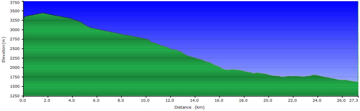
 The track that leads to San Francisco, aside from having endless curves is a continuous up and down. The slopes across the valley are too steep to build the road there. But the ones on this side are exactly the same. And that’s the reason for the sneaky road we follow. The foliage of the forest increases as we ride. We begin to see and hear different bird callings. Flocks of noisy parrots cross the canyons in short flights while we have a long way to get to the end, cross the stream and go back. The hummingbirds suck nectar from flowers in a hurry, as it was about to disappear. The trees are loaded with saprophytes. Yes, we are in the Yungas, in the jungle, the highlands are definitely behind. Here you can hold your breath to have a long drink. One could almost say there is an excess of oxygen.
Although we are only 5000 meters above sea level, the polar front keeps temperatures slightly above 32 degrees. Only at noon, when the clouds fade away and the wind stops blowing, the sun pleasantly warms us. Today we have to change long and shorts gloves several times depending on whether we descend or climb.
 When we get to San Francisco we change plans and instead of facing the last pass to enter the Calilegua National Park, we decide to leave it for tomorrow. After an odyssey to find decent affordable lodging in San Francisco, we end up at Los Ocultos hostel, which although under construction is the best option. Before the sun sets we go for dinner at La Tía Carola. Lucy and Freddy prepare us great homemade pasta preceded with eggplant and pickled peppers as appetizer. They also dine with us and the conversation goes on until 10. On the way back to the hostel, the dogs bark at us from the darkness. The trick to pick up a stone makes them stop, but only temporarily. We finally reach the frozen hostel room and get quickly under the 3 blankets on the bed. Tomorrow we sure enter the park.
July 4, 2011: From San Francisco to Calilegua National Park
Today we wake up to the sound of chacareras, one of the traditional folk tunes of Northwest Argentina. El Negrito Palma signs his passionate love misadventures accompanied by an andean guitar and a violin. Construction work at the hostel starts at 8 and Roberto doesn’t know we are sleeping upstairs. Nevertheless, the GPS alarm clock had just beeped. While having breakfast and preparing the panniers, Roberto repeats the cassette tape several times. We already know the songs by heart.
When we leave San Francisco the sky is still overcast and will continue like that throughout most of the day. The climb to the Abra de Cañas, Calilegua National Park boundary, is smooth but it takes us more time than we expected. Partly because of the cold (we don’t think it’s more than 50 degrees), but perhaps also for the lack of vitamins due to the reduced variety in our diet. The landscape we ride through is transitioning into the rainforest. Ferns and mosses start to be common and the humidity is increasing. From the pass we can see countless deep valleys with hillsides completely covered by vegetation, no matter how steep they are.
Upon entering the park, the downhill that will take us to the campsite to the east entrance begins. Shortly after we start going down, we stop to put some layers on as the speed increases the chill factor. As we go down the disappointment keeps growing. We expected to see more wildlife, at least birds and we've only seen a couple of species. Along the way we pass the ranger at la Mesada de las Colmenas. He gives us a trail brochure, a guide to recognize footprints of mammals and a tree catalog of the park. He also admits that it is difficult to see wildlife in Calilegua. According to him, in the Parque Nacional El Rey, an ecosystem similar to Calilegua, is easier to see animals.
 We keep going down and reach the Guarderia at the entrance. There, the rangers also confirm the lack of fauna. In addition they state that it’s colder than usual. We decide to camp overnight and take a stroll on a couple of marked trails. While having a snack after setting up the tent, a group of opportunistic urracas come to see what they can catch. They're really used to feed on tourists leftovers because they rest on branches less than 2 meters away from us. While we prepare tea and eat some cookies, they watch us carefully. At one time, while I have my hands busy with something and holding a cookie with my lips, one flies by to steal it, so close I can feel the tip of its wing touching my cheek.
 The hike on the two trails is as boring as the downhill ride. We only see a few birds and a frog. The light is attenuated under the foliage of the jungle, so we return to the campsite. We planned to take another walk in the morning but it seems unlikely we see anything else, so we will leave directly towards San Salvador de Jujuy. At least one of the trails introduces us to the Guarani culture, inhabitants of the Yungas, now trying to recover their identity. One of the rangers is a descendant of the Guaranís, and her facial features are totally different from the people of the highlands.
July 5, 2011: From Calilegua National Park to Jujuy
 Just going out of the tent, still within the campground, we see a few different species of birds. In addition to the food-stealing urracas that already visited us yesterday, some brasita de fuego (a kind of black and red punk crested bird) and some cerqueditos (with a black stripe mask over the white face) walk around pecking the ground. Some zorzales also appear, although they are more common since we have seen them elsewhere. Satisfied with these sightings we pick up the camp and set off. En route we stop at the ranger's office to ask for drinking water and we chat with them for a while. They recognize that the road to Valle Grande and the proximity of populations makes the fauna, especially mammals, go away looking for quieter areas of the park. On the road from the park to the paved road that goes to San Salvador de Jujuy, we are fortunate to see a toucan and we leave happier.
 Once in the asphalt, the atmosphere is bleak. The smoke from the chimneys of the Ledesma sugar processing plant, traffic of cars and trucks and endless fields of sugar cane, after the week we just spent isolated from modern civilization makes pedaling unpleasant. A couple of miles ahead we have the bus terminal of Libertador General San Martín and we quickly convince ourselves to jump on a bus and get to Jujuy in a couple of hours. Today it’s a reward day, so we are staying in the comfortable and elegant Posada El Arribo and go for dinner at the tasty Restaurant Maragaza.
 During the last few days we have travelled from the dryness of the highlands at 15000 feet to the lush jungle of the Yungas at 1500 feet passing through the Inca Trail and villages of 200 inhabitants. We have chatted with villagers and young girls unaware of the world outside their valley, even unaware of Facebook! We have seen a toucan, vizcachas and vicuñas. We first had an ocean of clouds under our feet and later over our heads. Here we put an end to a physically and mentally tough week but we would repeat it without hesitation. Well, maybe we would wait for the polar front to pass...