• Logbook
• Road Stars
Photo album:
• Amboró NP
Lodging and eating:
• Brisas de Comarapa Hotel Tel: 946-2123 (Comarapa)
• La Posada del Sol Hotel (Samaipata)
• Bibosi Hotel (Santa Cruz)
• Espacio Gourmet Inés España Restaurant Tel: 357-4888 (Santa Cruz)
Download GPS files for Amboró NP:
• GPS track & waypoints


On this stage we ride from Epizana to Santa Cruz through the old road linking Santa Cruz and Cochabamba. This road borders the Amboró National Park on its Andean section. From Santa Cruz you can access its Amazon part. Despite riding through the transition of ecosystems from 9000 to 1500 feet, the route turns out to be not so interesting. On top of that, the road is in pretty bad condition. At least we leave the mountainous and cold Bolivia behind and we move onto its hot and flat Amazonian lowlands.
Stage index:
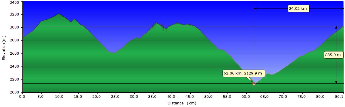
August 7, 2011: From Epizana to Churo (Profile)
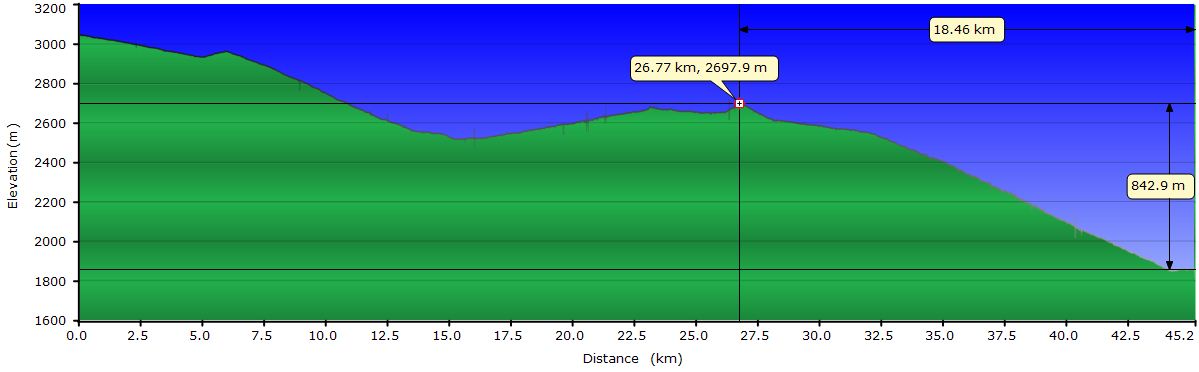
August 8, 2011: From Churo to Comarapa (Profile)
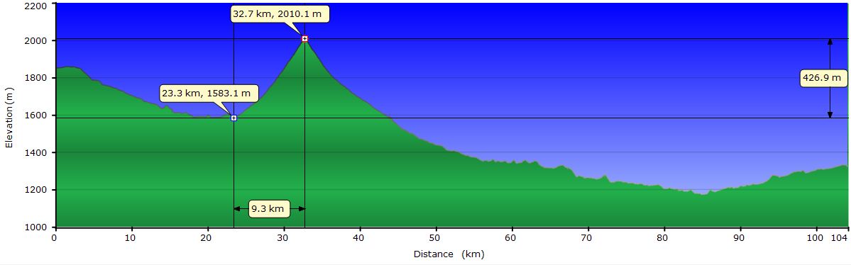
August 9, 2011: From Comarapa to Mairana (Profile)
August 10, 2011: From Mairana to Samaipata (via the Giant Fern Forest) (Profile)
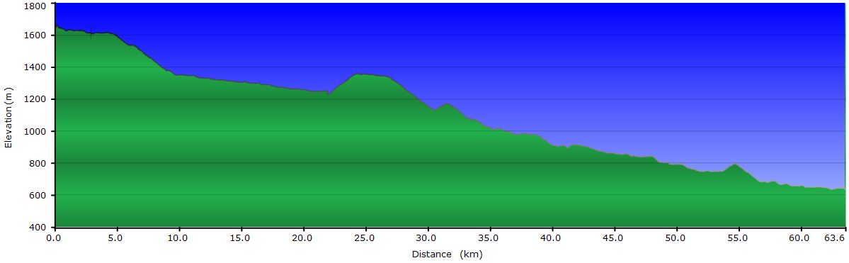
August 11, 2011: From Samaipata to Torno (Profile)
August 12, 2011: From Torno to Santa Cruz
August 13, 2011: Santa Cruz de la Sierra
Profile for the entire stage:

August 7, 2011: From Epizana to Churo
Our goal for today is to get to Pojo, the next “big” village on the road to Santa Cruz. According to our map, it’s about 44 mi of asphalt, but we discover soon that this map is not reliable. To begin with, the asphalt is good just for the first 6 mi, allowing us to reach the first hill of the day easily. From here we find first patches of dirt in the middle of the road. A few miles ahead, the road is mostly dirt with patches of asphalt. Here we ride from side to side trying to link as many asphalt patches as we can. We can ride on the left lane if needed, as there is very little traffic. Within a few miles, the asphalt patches have completely disappeared, leaving only the dirt and stones. On the other side of the pass, a giant mass of white clouds beyond the mountain range to our left, pushed by the winds from the northeast rushes down the hills at full speed, devouring everything that stands on its path. Half way down, the clouds lose strength and vanish.
 The descent from the pass leads to a river after losing 2000 feet of altitude, from 10500 to 8500 feet. As you can imagine, after crossing the river, we climb up another pass, a little lower though, at 10000 feet. The terrain is pretty bad, mainly due to the rocks. The wind has picked up and although it has been pushing us up until now, at the top of the pass, it becomes moody and blows from all directions. It creates small tornados ahead of us that dance from side to side of the track. The gusts lift sand waves that get stuck in our faces covered with sun screen. Before reaching the top, we stop to refuel energy eating a spicy sardine sandwich with Bolivian sand dressing. On the other side of the mountain, the wind is even stronger and the gusts are violent. Depending on the orientation of the track, we have to pedal to go downhill. On several occasions, we have to set foot on the ground to prevent the gusts making us fall off the bikes.
Around mile 25, our moral is down. Wind has that effect, it wears you out, not only physically but also psychologically. In part because it forces you to shift gears constantly to adjust your effort to its intensity but also by the constant whooshing in your ears that drives you crazy. Shortly before the second pass of the day, a truck stops behind us to pick a man who was lying on the shoulder waiting for a transport. This is our chance to end this suffering. We know that at some point we have to go down, but don´t know exactly when and after that we have another climb to Pojo. The driver says he is going to Pojo, so it seems that destiny is sending us a signal. On top of this, we have no answer for his question "Why on Earth are you riding around here?" Between him and the man that was just picked up, we get the bikes and panniers on the truck. We attempt to tie the bikes to the walls of the dumpster to use the tires to absorb the bumps of the road, but it takes 10 seconds to convince us that it´s going to be useless. Just when we start moving the truck takes a few bumps and the bike wheels jump about 4 inches from the metal platform. So we leave them lying on the floor praying that nothing will break and we cling to the wall near the cockpit to avoid the dust cloud the truck is generating. The back door of the truck constantly whacks the bed of the dumpster with a deafening noise masking the hits of the bikes bouncing off the ground. We put the two backpacks between the platform and the bikes, but probably in 5 minutes they will be in the other corner. In a few miles we start going down and we regret having jumped on the truck. We are now driving at 20 or 25 mph down a dirt road in bad condition, with a cliff on our side without protective fence and bouncing on the dumper. The downhill is not a fun experience. At least our “lane” is on the mountain side and not on the valley side, but our driver has no problem approaching the cliff if he considers the road is in better conditions there. We believe that he is training for the next Dakar in the truck category. The other passenger on the dumper nervously watches how the bar ends of the bikes come a little closer with each bounce of the platform. We go down almost 3300 feet to reach the second river of the day. Now begins the final climb to Pojo, but just before crossing the bridge the truck stops. We assume the driver is dropping off someone in the cabin here, but to our surprise this is the end of the trip. We jumped on the truck to make a reckless downhill... We load the bags on the bikes and set off for the next surprise.
After 2.5 miles uphill we arrive at San Miguel, where we find a rare traffic sign saying: Pojo to the right, Santa Cruz to the left. What? According to our map, Pojo is on the main road, but when we get closer to the shoulder of the track, we see Pojo down there in the valley and off the main road. No way! We are not going down there to climb back up tomorrow. We try to find lodging in San Miguel, but we're talking about a village of 20 houses. On top of that, everybody is at the festival in Villa Esperanza, a couple of miles back. A woman waiting for a bus to Cochabamba, suggests that we take a taxi to Churo, the next village with accommodation in our direction. The idea seems great, especially because we are not in the mood to keep riding.
We put the two bikes and the bags in a wagon type taxi, under the supervision of the skeptical taxi driver. We both sit in the passenger’s seat and we're on our way to Churo. This has been a worth ride. Churo is at the top of the next hill, 15 mi farther and 3000 feet higher! There, at almost 10000 feet of elevation and freezing cold, Mrs. Eugenia is very kind to allows us to sleep in the house she rents to the doctor when he comes on Sundays to visit patients. Today the doctor has already left, so we can crash there without problems. When we open the curtain that separates the "waiting room" from the "consultation room" we find a bed with a serum bottle hanging from the ceiling, a pair of used syringes on the floor and another handful on a table. It looks more like the slum meeting place of a bunch of junkies than a medical office, but good enough for us today. We set up the tent inside the room, like many other times, as a means to isolated us from the environment. We order two pique a lo macho (Bolivian dish consisting of fries, sausage, meat, onions and locoto, a kind of hot peppers) in the "restaurant" of the village and we gobble them up in the tent. This concludes a day full of negative surprises, a scary ride on a truck and a couple of pounds of sand stuck on our faces, mixed with sweat and sunscreen. Not even the landscape was worth it.
Before the sun sets, a new army of clouds tries to conquer the hill where the taxi has taken us up, but again it loses steam halfway down and dissolves in the air.
August 8, 2011: From Churo to Comarapa
We are slightly below 10000 feet and Comarapa, our destination for today is about 6000. We have seen on the IGM map that there are no big hills. So, in theory, today we have basically a long downhill, but given the unreliability of any of the maps we have, we don’t trust anything and we are ready for everything.
We start pedaling around 9:30 AM with a temperature significantly lower than any of the previous days. No wonder the name of the first village we pass: The Siberia. Today, we see again the cloud bank overcoming the crest and down the slope; only this time from inside. The damp and cold make us stop to put the gore-tex jackets on. The thick fog forces us to slow down to be able to see the stones in front of us. Judit goes in front, but I only see her silhouette, and that when I can look ahead momentarily. At some point I don’t see her, but I keep going down, assuming she still goes ahead of me. I increase the speed slightly to catch up with her, at the risk of hitting the rim against a rock. After a few minutes I still don’t see her and I don’t know if she stopped and I passed her without noticing. I don’t know what to do and stop on a curve to see if she is back and catches up with me. She is actually ahead and also worried about me since she has not seen me for a while now. After some minutes, I resume the descent totally confused and after a few yards I see her coming back up looking for me. What an awful experience! From here we ride down one right after the other. When we leave the fog, we stop for lunch. The clouds whiz overhead, disappearing a little farther down. Now we can appreciate the environment, much greener than yesterday. The trees are full of lichens and there are different types of flowers on the roadside.
The last 6 miles to Comarapa are one of those downhills you do not enjoy. We have to watch out for the rocks, barely able to look up from the ground. Our fingers are numb from the constant pressure on the brakes to reduce the force of gravity and the strong winds pushing us down the hill. Good thing it’s down, because if we had to climb this up, it would be a nightmare. Reaching Comarapa means rediscovering pavement and relieving our punished rears. Here, we find the Brisas de Comarapa Hotel (Comarapa Breeze Hotel), a pleasant and comfortable surprise. We guess the name is a sort of joke. After a shower, we go out for a walk, but after 5 minutes we are sand coated again. Supposedly, from here the road is paved, but we check it (positively) with a couple of locals before setting the expectations for tomorrow.
August 9, 2011: From Comarapa to Mairana
Mairana is the next sizeable town on our way to the Amboró National Park and Santa Cruz. It lies 1600 feet below Comarapa and we only have one 1300 feet pass. The challenge today are the 65 miles. The overcast sky relaxes the heat that would otherwise become unbearable at noon. We can notice we are moving to lower elevations. The climate becomes more tropical and there are lots of parrots, small birds and butterflies flying around. However, the vegetation alternates scattered trees and shrubs with several species of cacti.
Today a gentle headwind blows and we rush to keep going since we know it picks up in the afternoon. We ride at a good pace and as the landscape is not very interesting, we only stop a few times, just enough to regain strength and hydrate. In 5 hours and 20 minutes riding (6 and a half in total) we reach Mairana. We settle on a motel next to the road and go out for dinner to celebrate our km 5000 and the 43 miles up and down since we started our trip around South America.
August 10, 2011: From Mairana to Samaipata (via the Giant Fern Forest)
Today we want to visit the Andean section of the Amboró National Park. From Mairana there is a track that climbs to the community of La Yunga and from there it continues climbing up to an area called Los Helechos (the Ferns). In this area of rain forest, giant tree ferns can be seen, plus some wildlife. This area is nearly 3000 feet higher than Mairana and after yesterday´s extra effort, we don’t feel like pedaling up, so we take a taxi. We put the bikes in the trunk of a wagon taxi, I curl up on the rear seat backrest, while Judit share the passenger seat with the taxi driver's son. The decision has been a good one, because the slopes are between 8 and 11% and the terrain is pretty bad.
 Upon reaching the parking area of the Ferns, we put the bikes together and we ride the trail into the park, looking for the camping area we've been told exists. The increasingly narrow path becomes more and more complicated for cycling. After 3/4 mi, we leave the bikes and continue on foot. We soon realize that the campground can only be on the parking lot and the only possibility to pitch tent elsewhere would be on the lookout platform. We approach it and even there it’s not possible because it’s too small and in poor condition (going up I break one of the steps). The area of the giant ferns is dark and humid. The trunk of the highest ones measures about 9 feet tall and the leafy green umbrella creates a nice contrast with the blue sky. After walking the catwalks of the fern forest we leave the park. Going back to La Yunga we find a bright green little snake. It’s still, right on one of the ruts of the track and we push it away with a stick so the cars don’t run over it. It remains paralyzed, though. It’s either already dead or playing dead. A few miles ahead we hear a strange bird call that happens to be a species of toucan, but with smaller beak compared to the more commonly known.
 Back in La Yunga, we take the road that leads to Samaipata without having to pass through Mairana, hopping to see more wildlife, but besides a donkey and a hunter with a gun "just in case I see the tiger", we see nothing. The hottest part of the day finds us on the only climb toward Samaipata. At the end of the downhill, close to the village, we pass a few mansions with turrets that seem out of place. Samaipata is the get away from Santa Cruz, 3000 feet below. The wealthy build second homes here and come fleeing the heat of Santa Cruz. We stay at La Posada del Sol, a very welcoming place with a lovely garden and delicious smoothies.
August 11, 2011: From Samaipata to Torno
 After a hearty breakfast on the terrace of the garden´s hotel, we set off later than usual. The heat presses on, but most of the way today is downhill and the breeze produced by the speed helps make it bearable. At the exit of Samaipata we stop at the park office for information about a route that crosses the Amazon part of the park. The road exists, but you have to ford the river Surutú 5 or 6 times and according to the rangers, the water level can reach the waist. The aim was to visit Villa Amboró, where there is one of the most popular hikes in the park, but given the complications to get there and thinking that probably the fauna of this area is scarce due to the popularity of the hike, we decide not to go. We are planning to go to Madidi National Park, so we probably will not lose much bypassing the lower part of Amboró.
 On the way to Santa Cruz we stop at the waterfalls of La Cueva. In the short distance of 2/3 miles you can visit 3 waterfalls with crystal clear water that´s not too cold. It's noon and we take a shower on the 3rd one and dry off in the sun on the pink sand beach. The wind begins to blow strong and creates clouds of sprayed water that cools off our skin.
The road follows the river Pirai, that occasionally flows through gorges and forces us to climb. Although this causes us to sweat, the views from the top are more spectacular. In between the vegetation some blooming trees stand out: yellow, orange, purple... In this area we can observe that the species of parrots we have been seeing in recent days feed on the flowers of the orange trees.
 Today we wanted to stay in Bermejo and tomorrow to make a trip to a nearby crater, but we almost pass Bermejo without realizing it. It's a town of only a handful of houses and the road to the crater is not signed. We look a little farther for a signpost but find nothing. A few miles down we ask at a fruit stand on the roadside and they tell us we've already passed the junction. We are too lazy to climb back, so we continue down the road hoping to find accommodation in Angostura. But at Angostura we find that, although they told us we would find lodging here, there is no place to sleep. We have already ridden 40 mi and it will soon start to get dark, so the solution is to put the bikes on the roof rack of a micro(bus) and go to Torno, where "for sure" there is lodging. After checking out some accommodations, we end up in a "3 star hotel", certainly measured with the Bolivian scale. The 14-inch television, on a stand 6 feet from the ground would have been a bit far if we have had the slightest intention of watching TV. All we want is a shower and a bed. The shower at the waterfall of La Cueva and the nap on the beach were much better, but this is good enough for tonight.
August 12, 2011: From Torno to Santa Cruz
To avoid the stress of entering the big city, we take a wagon-like taxi, put the bikes in the trunk and go to Santa Cruz. There we settle in a hotel and we take it easy.
August 13, 2011: Santa Cruz de la Sierra
 Today we visit the Biocentro Güembé. The main points of interest are the butterfly garden and the aviary. In the butterfly garden there are a variety of species, including the Morpho family with its incredible electric blue wings. In the aviary there are macaws and parrots of different species, a pair of toucans, urracas, and although out of place, peacocks. As always, the controversy of having animals in captivity comes up to our minds. We can see them up close, but at the expense of locking them up. At least, both the aviary and the butterfly garden are very ample. Unfortunately, orchids bloom in spring, so we can´t see a single one.
 The park includes a set of swimming pools linked by waterfalls where the upper class cools off or sunbathes. There is also a small museum displaying an interesting collection of photographs and texts covering the history of cave painting all over the world. The statues scattered around the gardens deserve attention for its originality. A huge insect made of bicycle parts catches our attention.
Tonight we are catching a bus that will take us to Trinidad in the Beni province.