• Logbook
• Road Stars
Photo album:
• Salar de Uyuni & Lagoons route
Available documents:
• Roadbook for Salar de Uyuni and lagoons route
• GPS track & waypoints
THANK YOU!
Lodging and eating:
• Toñito Hotel (Uyuni)
• Edén Atacameño Hostal (San Pedro)
Bike shop:
• Bruna Bicicletas (San Pedro)
Did you find our website useful?
HELP US by buying a GIFT in our store:


Or donating:
THANK YOU!
Available documents:
• Roadbook for Salar de Uyuni and lagoons route
• GPS track & waypoints
Last stage of our journey. Certainly the most demanding one, both physically and mentally, but also one of the most rewarding. The main difficulties are the cold temperatures (below freezing for several nights), elevation (between 12000 and 16500 feet), the shortage of supply points, wind and especially the awful conditions of the roads. Given this description, you may ask what does the Sud Lípez have to ofter for similar ordeal be worthwhile? Well, it is not an easy question to answer in a convincing way. It is true that landscapes and scenes are incredible like flamingos at 13000 feet, red, green, white and gray lagoons, multicolored steaming volcanoes, hot springs, fumaroles and infinite salt flats, but you have to pay a high price to see them. Undoubtedly, the desire to cross this area has a fairly strong component of sport challenge, another of wishing to explore the unexplored and a touch of masochism. The result is a dry cocktail with high alcohol content and even a little bit of bitterness in some sips. A route like this is only recommended for cyclists experienced on long journeys, very fit and with a great self-confidence.
Stage index:
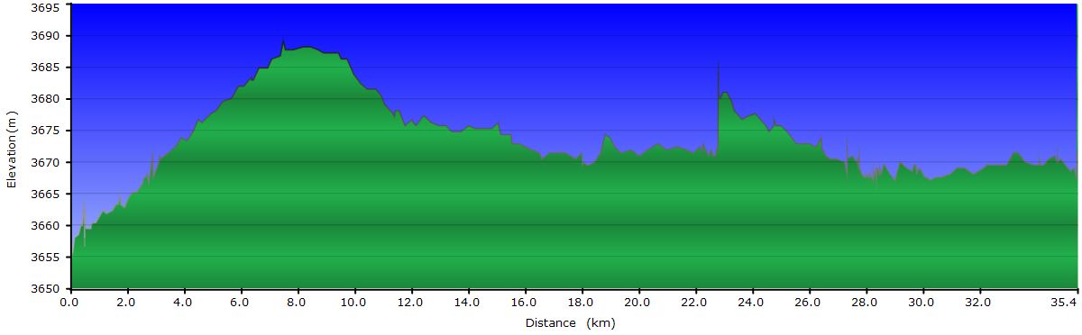
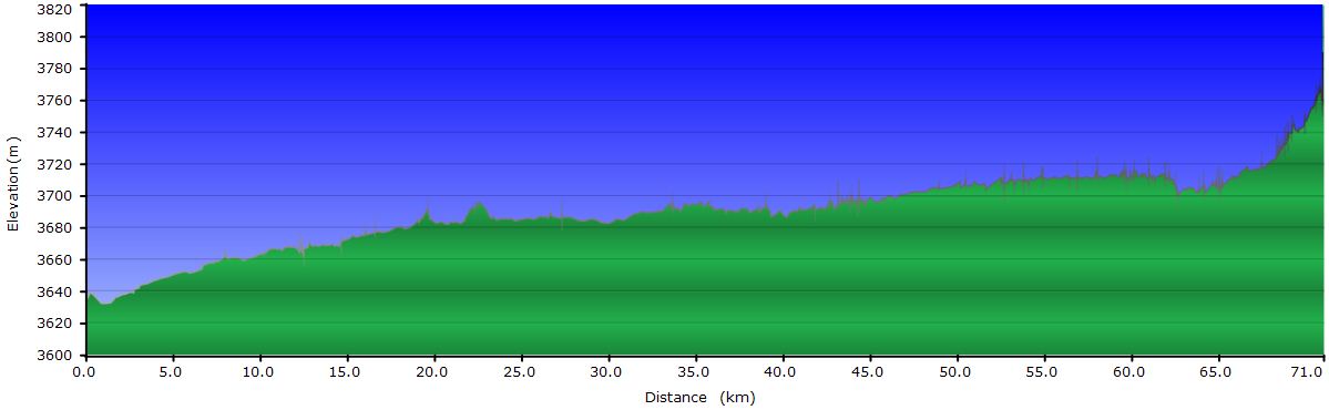
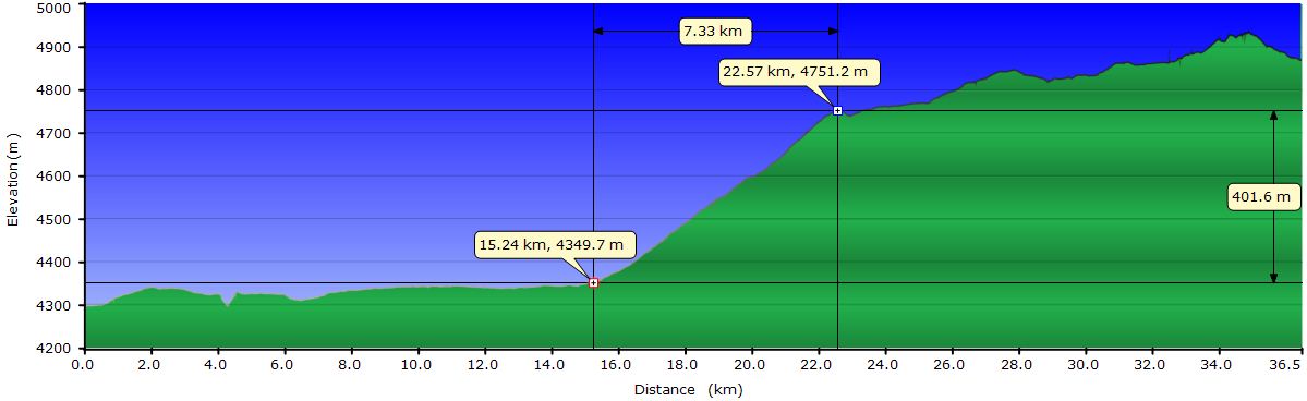
October 8, 2011: From Uyuni to the Hotel de Sal (Profile)
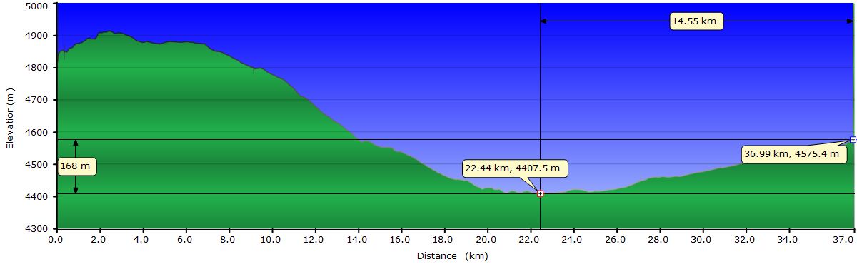
October 9, 2011: From the Hotel de Sal to the Inkawasi Island (Profile)
October 10, 2011: From the Inkawasi Island to the Grotto of the Galaxies (Profile)
October 11, 2011: From the Grotto of the Galaxies to San Pedro de Quémez (Profile)
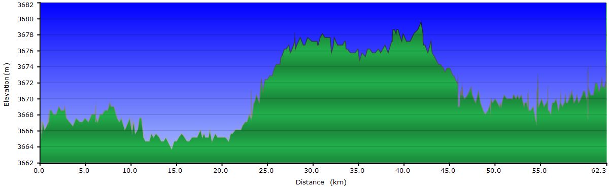
October 12, 2011: From San Pedro de Quémez to the end of the Salar de Chiguana (Profile)
October 13, 2011: From the Salar de Chiguana to the Laguna Hedionda (Profile)
October 14, 2011: From the Laguna Hedionda to the Hotel del Desierto (Profile)
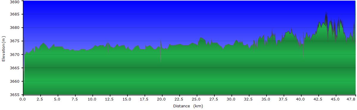
October 15, 2011: From the Hotel del Desierto to the Laguna Colorada (Profile)
October 16, 2011: From the Laguna Colorada to the geysers Sol de Mañana (Profile)
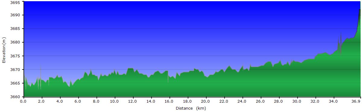
October 17, 2011: From the geysers Sol de Mañana to the Dalí Desert (Profile)
October 18, 2011: From the Dalí Desert to San Pedro de Atacama (Profile)
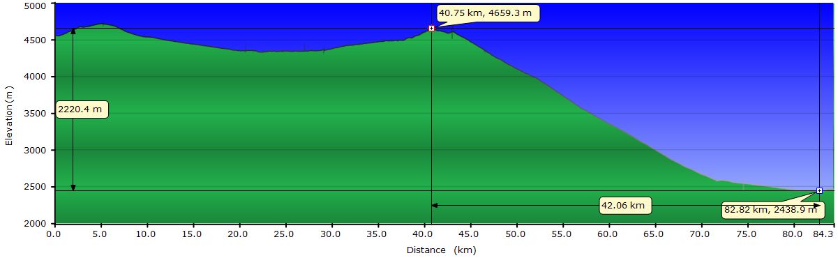
Profile for the entire stage:

October 8, 2011: From Uyuni to the Hotel de Sal
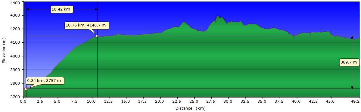
The day couldn’t start better. The abundant breakfast at the Hotel Toñito fills us up with lots of energy for the first stage of our last route. With our bellies full, we return to the room to complete the final preparations. Putting the tights on again gives us a nice feeling. After 10 days without pedaling, today we will be riding on the Salar de Uyuni and that makes a shiver run down our spines. It is a mixture of excitement and fear. On the one hand, the pictures of the Salar and the lagoons of the Eduardo Avaroa Reserve are incredible. But on the other, the sum of the elevation of the route (between 12000 and 16500 feet), the sandy terrain, the wind, the mountain passes and the absence of villages, make this route very demanding. Or so say the cyclists who have already been there. We have prepared ourselves as much as possible. We have GPS waypoints and elevation profiles and have split the more than 300 miles in 13 days according to the difficulty. Today is the big day. Let's see how much of that holds true.
With the bikes fully loaded, including food for 3 days and 5 gallons of water, we say goodbye to Chris and Susi, the owners of the hotel. They are super-nice people. Yesterday we went through the route with Chris, and made some adjustments as a result of his advice. Then we talked about different topics with both for a few hours. Today we say goodbye with affection. We give them our bike mirrors as a present. Chris goes away and comes back with a packet of 100 grams of Spanish ham! You don’t know when the last time we had Spanish ham was! Finally, we take a group photo in front of the Hotel and leave. Now, yes! We are headed for the Salar.
 The road till Colchani, on the shores of the Salar, doesn’t have any especial interest. On our left, from a few miles ago we can already see the salt. Water evaporation causes mirages and makes the peaks on the horizon fuzzy. The buildings near the salt seem to float on water. The Tunupa volcano, on the North shore of the Salar, serves as a point of reference throughout the day. In Colchani, the villagers are celebrating something, as in all the villages we have visited in Bolivia. We get closer to find out what’s going on, but the level of alcohol in some of the villagers is too high and we go back. From one of the street intersections we see a concentration of 4x4 on a side street. Thinking that perhaps there is something of interest, we get closer. We ride through some rubble and unfortunately, the rear derailleur of Judit’s bike catches on a rock and bends backwards. Although she realizes quickly and brakes immediately, the derailleur is tangled and twisted between the spokes. All our excitement falls apart. This route was the perfect end for our trip and now it seems to be ruined. We unload the bike and analyze the severity of the accident. Luckily nothing is broken, only a couple of bent parts. We borrow some pliers and straighten them the best we can and put the wheel back. The derailleur has some play, but it seems to work, at least with the bigger cogs. Part of the problem is that the cable must be going bad since it has been acting up for some days. Satisfied with the temporary fix, we leave Colchani in search of the sea of salt.
 Little by little the dirt track becomes salt. This area keeps a certain level of superficial water throughout the year and there are several salt production zones. In humid areas, our wheels sink. It seems as if we were riding on snow. In dry areas we hear how the big grains of salt are crunched under our wheels, something we have never experienced before. We approach one of the salt mines where a man is shoveling salt from underwater and piling it up on 4-feet high pyramids for drying. He’s covered from head to toes, even the face. The highland’s sun, in addition to the salt reflection, burns the skin. We confirm our direction with him and continue on. We follow one of the many 4 wheel drive tracks marked on the salt flats. The problem is deciding which of the countless tracks to follow. We opt for the more obvious one until a less marked one veers to the right. According to the waypoints we have loaded into our GPS, this could lead us to the Ojos del Salar (Salar Eyes). After a few hundred yards we arrive to the Ojos del Salar, a series of bubbling puddles. How these are formed and where the water and gases emanating from them come from is a mystery to us. We take another of the tracks to our next point, the Hotel de Sal. The truth is that this area is a maze of tracks, which makes navigation not obvious.
 In the distance we can see what looks like a building that could be the Hotel de Sal, our destination for today. It seems to be much closer than the GPS indicates, but it can’t be anything else. The building is made entirely of salt, except for the roof. The salt blocks that form the walls are glued with more salt, probably wet at the time of construction. Inside the old hotel there is a small museum with sculptures of salt but not very impressive. However, stepping on salt, sitting on salt chairs and salt tables is something that cannot be done in many places. Our next concern is to replace the shift cable on Judit’s bike and try to correct a little the derailleur. After fighting for over an hour, we get a good enough result, hoping it holds for the rest of the route.
As the sun goes down, we put up the tent next to the hotel. Although the wind has stopped completely, as we cannot nail the pegs in the rock-hard layer of salt, we prefer to be shielded just in case it picks up during the night. The temperature starts to drop as the clouds on the horizon begin to change colors. Turning around we can see all shades of color of any sunset we have ever seen. To the East, over the peaks still illuminated by the last sun rays, the clouds are purple. To the North and South become rosy and when pointing to the West, orange and red tones dominate the skyline. The moon, almost full, is watching us high in the sky as we get in the tent.

One of the reasons to get to the Hotel de Sal (transformed into a museum today), is to avoid the dangers of camping in the middle of the salt flats. We have been warned about the chutos (car thieves). They cross the Salar at full speed from the Chilean border to Bolivia. In a recent occasion, one of them ran over the cyclists bikes, right next to the tent.
October 9, 2011: From the Hotel de Sal to the Inkawasi Island
The day begins with a strange feeling. When we stick our heads out of the tent in the early morning, we see everything is white. The idea of camping on the snow is the first thing that comes to mind. But no, this is the same salt as yesterday.

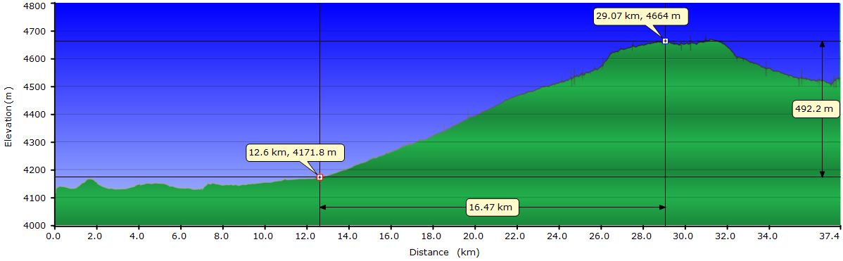
Our route for today is simply a straight line of about 37 mi toward the Inkawasi Island. A couple of 4WD tracks go deep in the Salar from the salt hotel. A guide tells us, both of them lead to the island and we take the one closest to the path we have marked on the GPS. We start with an overcast sky and the salt doesn’t have the flashing white we were expecting. In addition, we are following the blackish markings of the jeeps, which takes away some of the charm. Not that we cannot separate from them and seek our own way. The truth is that currently, the Salar intimidates us too much to leave the safety of the tracks. The fear increases when we come to an area where lots of holes concentrate, exposing the water under the salt. It seems like we're on a salt crust about 4 inches thick and everything under is water. Looking through the holes, we can’t see the bottom, just the hole salt walls. The largest are the size of a bike wheel. Why did I think about this comparison?
 We keep following the jeep tracks religiously, separating from them only slightly to avoid the holes. It seems like a seal could jump out of one of them at any time. Around 11AM the 4WDs begin to pass us loaded with tourists heading for the island. Far from all following the same route, each one goes on a different track covering a band of at least a couple of miles. They pass us on both sides, but always at a safe distance. Many of the tourists roll down the windows to encourage us or take pictures. If they knew that today´s stage is the easiest... No ups or downs, no wind, good temperature... They probably also feel that respect for this sea of salt.
As we ride more and more miles over the salt, our confidence increases and we venture off the tracks. The feeling is much nicer, even though the cars still pass frequently. We reach an area where salt forms very peculiar polygonal structures. Most are hexagonal, but there are pentagons and quadrilaterals. The edges of the polygons are marked by 1-inch salt ridges that creak beneath our wheels.
On the horizon we can already see the Inkawasi Island. Behind it, other islands and on the background the snowy peaks that probably mark the border with Chile. When we see an object on the horizon, for the first moments, it seems to float in the air, at a short distance from the salt. Vehicles seem to hover over the lake. A diffraction effect makes them appear much taller than they really are. Little by little we are getting used to these visual illusions, but calculating the distance is still impossible. The lack of references forces us to trust the GPS for how much we have left, even though we have been seeing our destination for hours. The last miles are tougher due to the west wind, which is the direction we are going. On top of this, the salt plates in this area are further apart and the joints form dips. The effect on our butts is like pedaling over giant cobblestones.

Finally we reach the island and we go around to discover a beach where the jeeps land. There is an office for the collection of fees to access the island, bathrooms and even a shelter that we use to spend the night. On the beach there are at least 15 vehicles and a crowd of tourists taking pictures. We just want to settle down and take a break before eating something in the restaurant. Lukas, a Swiss cyclist has arrived before us. From his camp, he has seen us coming and has approached to chat. While we devour a llama burger and a beer, we talk about our respective plans. He comes from the North coast of the Salar and tomorrow heads south, like us. However, it seems that he is faster than us and there is no attempt to ride together. Of course, we were also riding at a faster pace 20 years ago...
The clouds are still covering the sky, wind gusts have increased considerably and the cold has taken over the place. From the windows of the shelter we watch a sunset not very spectacular before going to bed.
October 10, 2011: From the Inkawasi Island to the Grotto of the Galaxies
The light coming through the windows awakes us. We hurry to put on several layers of clothing to climb to the top of the island and see the sunrise from there. We arrive a little late, but still, the show is gorgeous. The island triangular shadow projects on the white steppe on which it sits. In the sky there are only a few white clouds to break the blue monotony. The view, with the sun still low, looks like a picture painted in white and blue. Only the top of the Tunupa volcano breaks the blue and white scene with its purplish color. The landscape reminds some of the islands we visited while kayaking in the Sea of Cortez, but here a sea of salt replaces the liquid. The island is inhabited by blooming giant cacti.
 After talking to a couple of guides, we decide to take a path that will lead us almost directly to the Grotto of the Galaxies. We had this route in mind, but in Uyuni we were advice to avoid this alternative route because this area of the Salar takes longer to dry than the normal route to Chuvica. However, the guides tell us that it’s dry and explain us which way to go. So, we head straight to another island following their directions, away from any vehicle footprint. The sky is clear today and we enjoy the immaculate purity of the salt. The terrain is rugged due to the salt plates and bumps that we need to dodge, but we enjoy it more than yesterday. The salt here is as we had imagined. To the east, you see only salt and sky, and it’s difficult to identify where one ends and the other begins. In our progress, salt crystals flash like tiny lighthouses, indicating the way to follow. Or maybe misleading us into a giant hole...
Little by little, the island in front of us gets bigger. We begin to see its shape more defined and also the 3 adjacent islands the guides told us about. When we reach them, we pass between the main island and the small ones and turn slightly to the left. The passage between the islands gets interesting because the salt begins to be wet and the wheels start to sink. We continue trying to ignore it, until the salt becomes something like a smoothie. The area is dotted with yellow stains and smells like sulfur. Once more, the Salar frightens us and we ride through the area as quickly as we can. After the islands, the salt becomes compact again and also very smooth, with no plates or bumps. Here we pedal at full speed towards the coast, already visible in the distance.

Before reaching the shore, the salt is wet again. In this area it forms more pronounced seams between the plates and they even overlap. After a difficult couple of miles we land on dirt. We safely crossed the Salar and a feeling of relief and success at the same time runs through our body.
The dirt track taking us to the Grotto of the Galaxies has sandy sections but we can pedal almost all of it. By the time we get to the Aguaquiza junction, the west wind blows with intensity. The last 2.5 miles to the grotto are endless. Finally we get there and Nemesio, one of the two discoverers of the cave welcomes us. After giving us an introductory explanation, he invites us into the cave. The rock formations are completely unknown to us. You can admire a mixture of very thin perforated flags and conglomerates that resemble petrified plant leaves. Some of the sheets are so thin that light passes through them as if they were made of alabaster. Next to the Grotto is the Devil’s Cave, which concentrates a large number of chulpas, cavities where some of the pre-Inca cultures of the Andean highlands buries their dead. Atop the hill we can observe petrified cacti.
 The decision to take this route has been really a good idea. Besides avoiding the usual tours operators' route, we have been able to admire the beauty and originality of the formations of the cave and get into a cave with plenty of chulpas. The wind keeps picking up and we decide to camp behind the ridge that houses the ancient cemetery of the culture that inhabited this region, the South Lípez. Before we take shelter in the tent, we clean the bikes and remove the numerous clumps of salt stuck to the frame and around the transmission parts. The full moon is hiding behind some skinny clouds, but its intensity is so strong that we can easily walk without headlights. The wind shakes the tent from time to time, but we are already on land and we can sleep safe.
October 11, 2011: From the Grotto of the Galaxies to San Pedro de Quémez
To take advantage of the absence of wind, we start pedaling at 7:30AM. After a few miles, we take a track that crosses a new salar, reducing the distance to San Pedro de Quémez. This track is only passable in the dry season and when the salt has already dried. This route is in very good condition, especially in its second half, where it’s made of hardened, very smooth clay. Here we reach 14 mph, helped by a slight tailwind. Emerging from this salar, the 2 mi left to San Pedro have some sand and washboard.

When we arrive to San Pedro, the town is deserted. The doors of all houses are closed and we see nobody on the streets. We approach the municipality to request information and we find Omar, the mayor, who is meeting with two other people. They quickly put off the meeting to help us. They call Hugo, professor of history, who will guide us through the museum that will open to the public shortly. The museum has a small exhibition of the more than 3000 archaeological pieces found nearby. The jewel of the collection is "The Quémez girl," a 4 years old girl from the pre-Inca Tiwanaku culture sacrificed when they decided to settle in San Pedro. The mummy is in very good condition and it still retains traces of skin. Then we go to Pueblo Quemado (burned village). This is the old village of San Pedro. At the time of the war between Chile and Bolivia, it was called San Pedro de Buenavista (nice view). The Chileans seized it in a raid, but the Bolivian army stroke back and expelled them. In their retreat, the Chileans burned the town to the ground. The survivors moved to another location and it wasn’t until 1930 that they decided to return to the original site. The town was renamed San Pedro de Quémez.
San Pedro has a couple of stores to stock up on water and supplies for the next days. Besides the expensive Tayka Hotel, San Pedro also offers rooms and food in a couple of houses. None of these services has sign on the door and they can only be found by asking the villagers. The stores have a reduced food variety and in limited quantity, but it is the last town to buy supplies for the next week. The municipality has satellite internet, but you have to contact the mayor to get access to the room.
After visiting the museum and Pueblo Quemado, the West wind is blowing strong and we decide to stay in San Pedro for tonight. It seems that the pattern is North gentle wind in the morning and from the West at noon, increasing in intensity as the day progresses. At about 5 pm, the wind is very strong. The mountain ridge at the other side of the salt flats has disappeared behind a sand storm.
At the town hall they told us there are two ways to reach Chiguana: the main track and another track that runs through the salt flats. The first one is shorter, but we are told it has sandy areas with washboard. After today's good experience, we will take the one through the salt flats.
October 12, 2011: From San Pedro de Quémez to the end of the Salar de Chiguana
A few miles from town, as advised in the municipality, we leave the bumpy road and drop down to the salt flats. Although the terrain improves significantly, it is far from being the fantastic track that yesterday took us to San Pedro. This detour, however, returns to the main road after about 4 miles. The washboard joyfully welcomes us to resume crushing our poor butts. This road continues towards the town of San Juan, but we veer right towards the Salar de Chiguana. Before reaching this new salt flat, we go through the Rock Army. This is a rather large field of vertical rocks, with many holes, that seem planted in the ground. The imagination of some tour operators has baptized the area with a name that spurs the curiosity of the tourists.

Before reaching the salt flat we can already notice the wind. It's starting to turn from North to West. We cross the Salar de Chiguana and arrive at the military checkpoint of the same name. We ask for shelter from the wind to the 6 soldiers taking care of the post and chat with them awhile. After lunch we resume the ride through the southern part of the salt flat. The wind intensifies and turns, coming now from the West. The path leaves the border of the salt flat and gets into increasingly sandy areas. At the extreme south of the salt flat we start looking for a place to camp. The best spot we can find is a canyon that concentrates some shrubs of sufficient height to serve us as a parapet.
October 13, 2011: From the Salar de Chiguana to the Laguna Hedionda
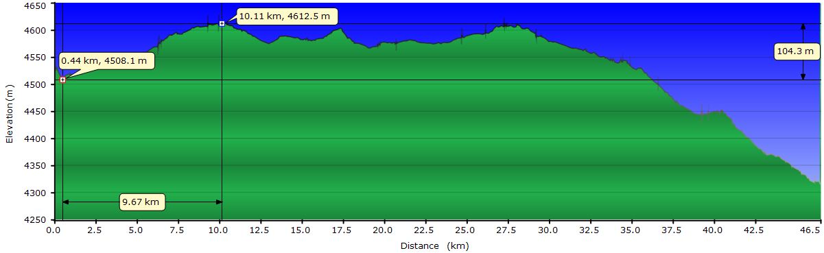
Dragging the bike back to the road helps us to warm-up before the sandy climb to the international road. Here the terrain changes dramatically. This road is wide and compact. Furthermore, the slope is gentle and we can ride relatively quickly. On our right hand side is the volcano Ollagüe, bordering with Chile. At its top, we can see spots of all colors due to the different minerals it spewed during its last eruption. It’s still active and from the viewpoint (a few miles ahead) smoke can be seen gushing out from one of the sides.

We follow the international road for about 14 mi, where we leave it to start up the main mountain pass of the day. The turn off, besides being in the GPS map, is easy to recognize due to the jeeps ongoing traffic. The climb to this 14100 feet pass is short but intense. The terrain is bad and even the 4x4 crawl up slowly. On the other side, it drops a bit, but we will stay above 13500 feet for the rest of the day. Here the terrain is even worse. The deep ruts form the jeeps, the sand and rocks make it quite difficult to pedal. Fortunately, it’s downhill for the most part and we have tail wind.
After around 24 mi we reach the first of the lakes, Laguna Cañapa. Right now the wind is already strong. We take cover for a few minutes behind the wall signaling its name. When we resume, the road approaches the shore and we realize that there are two flamingos feeding on the lake. The next hill to overcome involves choosing which of the infinite jeep tracks we want to use. All of them have deep ruts in the sand and long stretches with washboard, so we have to opt for the less horrendous. Once we go over the hill the Hedionda Lagoon and the Flamingos Eco-lodge building come into view. As we get closer, the dots on the water surface turn into flamingos. There are several hundreds, mainly concentrated at the shore closest to the hotel. Luckily the last few miles are downhill on a smooth terrain, allowing us to use every effort to fight the wind until we reach the Eco-lodge. Once there, our suffering is over for today. The reward of a hot shower and some biscuits is well deserved.
 Once recovered, we go back to the outside world to watch the flamingos closer. Surprisingly, we can approach them up to 25 yards before they start walking away slowly toward the center of the lagoon. It seems incredible that they can live in this climate, at 13500 feet above sea level and with furious chilling winds.
The bed in the room has two blankets and two quilts. There is no heating, all energy is solar and it is used for the light bulbs that are distributed throughout the building. Before our hands freeze while we read and write in the bed, we take off the fleece and plunge into the thick layer of blankets and duvets. Tomorrow begins the really hard part...
October 14, 2011: From the Laguna Hedionda to the Hotel del Desierto
Unlike other days, the wind has been blowing all night long. Bolivia’s flag is still whipping, like yesterday when we arrived. As the sun begins to illuminate the peaks of the volcanoes across the lagoon, flamingos keep their head sunk in the body feathers, still in the center of the lagoon, with that peculiar pose standing on one leg. We approach the shore to take some pictures, but go back quickly into the building, because the strong wind is freezing. We planned to leave at 7 AM to take advantage of low wind hours, but it seems the plan has failed. We have breakfast quietly, until we eat it all (and some from the neighboring table) and start pedaling around 8 AM.

The sun is already high, but doesn’t warm us at all. In fact, our hands and face, despite the tubular scarf and gloves, freeze in a few minutes due to the wind. During the first few miles, we go around the chain of lakes in this area: Chiar Khota, Honda and Ramaditas. Several of them have flamingo flocks starting their daily routine. This section serves to remind us of every one of the sored parts of our body, thanks to the washboard and the rocks on the road. After the last lake, it starts a sand and gravel desert crisscrossed by endless ruts that rejoin in the horizon. Each jeep tries to avoid the multiple paths with washboard by creating a new one. The landscape seems a sterile plowed field. Our problems also begin here, not only because it starts to climb, but because we have to choose which rut to follow. It’s mandatory to pedal on one of them. That or drag the bikes over the mixture of gravel and sand. We are lucky and select one that doesn’t have a horrible washboard. Well, actually, we keep changing ruts choosing the least bad. However, based on the information we had from other cyclists, we're lucky, because we do not have to push the bikes as they had to. For this flat area, the sun and wind apply a hot-cold treatment, as if it they were a physical therapist. When the wind blows, we freeze. When it stops, the intense solar heat is transmitted through our dark clothes to the skin.
As we move forward and gain elevation, the terrain becomes increasingly sandier to the point where it is impossible to pedal. It's time to get off and push. Anyway, we're almost at the Paso del Inca, a gap in the rock through which the route continues. From there, we can pedal again, jumping from rut to rut, towards the main pass of the day, at 15400 feet of elevation. More than a pass, it's a rounded hill that must be overcome. Again, there are a myriad of jeep tracks, which indicate that there will be washboard. The wind, following the same pattern as the previous days, still blows from the North, which helps us to climb and move forward in spite of the bad terrain. We ride a few miles above the 15000 feet. The legs can keep going, but the lack of oxygen strangles us. We have to stop frequently, especially after any minimal climb. But we can’t stop for long since we freeze due to the wind. And there's nothing to use as a shelter. Nothing.
.jpg "Penitentes")
Finally we overcome the hill and the descent begins. The terrain is still terrible. Where the rocks are acceptable, deep ruts slow us down even going downhill. If you lose your balance and deviate from the center of the rut, the front wheel climbs up the sand walls and slows you down. If you are lucky, you swerve between the two walls of sand and keep going. If you are not fast enough, you’ll end up jumping off the bike to avoid falling over. Across the valley there is a chain of volcanoes with beautiful multicolored ridges. Halfway down we find a field of penitentes (tall thin blades of hardened snow or ice closely spaced with the blades oriented towards the general direction of the sun). They are the remnants left from the July 4 snowfall, from which we escaped by changing the direction of our trip. Scattered over the hill they really look like a procession of penitents marching heads down looking for their forgiveness.

In the midst of the nothingness, crisscrossed by gravel jeep marks, a wall is erected indicating the turn off for the Hotel del Desierto. What an appropriate name! The couple of miles to the building take for ever. At this time, the wind has turned and comes now from the west, towards the direction we are heading. It takes us almost half an hour to arrive, but we achieve the goal of the day. The pleasure of a hot shower is a great reward, but the satisfaction of having passed today’s test is even a better one. We cannot deny that crossing the Sud Lípez has a lot of physical challenge, but today we had a good variety of points of interest: flamingos at 14000 feet, sulphurous lakes with shores covered in salt, ice penitentes and horizons full of magnificent volcanoes.
October 15, 2011: From the Hotel del Desierto to the Laguna Colorada
Same as yesterday, the wind has been blowing all night. We start pedaling covered from head to toes, but the fingers get numb quickly. Partly because of the cold, but also by the lack of blood flow due to the force with which we grab the handlebar to be able to swerve and keep the balance when overcoming rocks or after the front wheel gets stuck against the sides of the sand rut. To our right we have the chain of volcanoes with colorful tips we saw yesterday. Now, with the morning light, they show their best colors, but we cannot appreciate it while riding. The horrible terrain forces us to keep looking at the “track”. At least, we have tailwind. But if we stop, the impact of the cold gusts makes us shiver.
 The terrain is so bad that the first 5 miles takes us 1:45 hours. Part of the reason is that Judit’s seat is totally loose after the rattle during the recent days. We need several adjustments before finding an adequate position. About mile 5 we reach a rock outcrop where some tourists have stopped to watch a vizcacha. When they see us coming, the poor animal is no longer the center of attention and we become the stars of the moment. Here we find the main road, recently “maintained”. Supposedly, a couple of weeks ago the bulldozer blade worked on it, but the current condition is already ho-rri-ble. The track is wide, but the jeeps have ruined it entirely and it is all washboard now. There are many long stretches where it is impossible to sit on the saddle. We had never seen such deep washboard. The difference in height between the peaks and valleys is up to 8 inches. Thanks to a strong tailwind we can get through even the worst stretches without having to push the bikes. In the few sections where the road is firm and smooth, we reach speeds of up to 15 mph without pedaling, only pushed by the wind. Sometimes is so strong that it picks up dust and gravel and blows it against our backs, but we keep upright using our body as a sail.
Today we ride more than half of the distance without seating on the saddle and our butts are grateful for that. In the short smooth stretches, we enjoy a dry landscape, harsh and lifeless. Sand, rocks and volcanoes make up this high altitude desert. One finds its beauty in the contrasting colors of the earth and the blue skies. Eventually, we come to the famous Stone Tree, a rock carved by the sand and the raging winds.
 Today if it wasn’t for the help of the wind, we had not reached the Laguna Colorada by any chance. Not because of the distance, but the horrifying conditions of the road. Given the wounds on our butts, if today we have had to pedal we would have screamed at every bump and every undulation of the washboard. Fortunately, we let ourselves be pushed by the wind gusts and just pedal to get out of the sand banks or climb the short hills. It is a joy to be transported and realize that we will reach our ambitious goal, the Laguna Colorada. However, the continuous whacking on our poor bikes for miles and miles has to have a consequence in some way. We pray the racks don’t break or collapse. A bottle of water is already leaking through a hole.
We keep moving ahead without even stopping to eat, just in case the wind changes direction. We come to a large sand dune that makes the road turn 90 degrees. This is how the Laguna Colorada appears in front of our eyes, but still far away. Nevertheless, we can appreciate the intense red water. This is not a reddish hue, but a deep crimson highlighted by the white crusts of salt and borax islands not covered by water. From a distance we see that the same wind that pushes us, arises violent white clouds of borax.
Finally we arrive at the park office, where we pay the entrance, and to the few houses that provide accommodation for tourists who spend the night here. After devouring a can of tuna and some of the rolls we have, we walk to the lagoon viewpoint. Walking is a way of saying that we don’t go by bike, because we walk the mile that separates us from the lookout with clumsy steps caused by wind gusts. From the viewpoint we can still see areas of red water, but not as clearly as we have seen from the distance. We’ve been told that the algae that give color to the lagoon are more visible when the wind stirs the surface. The wind has not decreased its intensity, so some other factor must play a role. The flamingos are still eating as if the gale force wind was a nice breeze. However, all are lining up facing the wind to offer the minimum resistance. When they change orientation, the slim and elegant birds become an untidy ball of pink feathers.
Worn out but very pleased to have arrived here today, we make our offerings to God Aeolus, thanking Him for the assistance and asking that at least He doesn’t blow against us tomorrow.
October 16, 2011: From the Laguna Colorada to the geysers Sol de Mañana
It seems that Aeolus sacrifices are paying off, as the day starts totally calm. Taking advantage of this, we set off, but after 3 miles, we leave the bikes on the side of the road and walk down to the shore of the lake for a closer look at a flock of flamingos. The road is at a certain height off the water and the view from it is magnificent. Looking ahead, the sun, still low, is blinding us, but looking at the sides, we can see perfectly the red color after which it’s named. The surface of the lake is still half frozen and in some areas the flamingos have to walk in a kind of frozen watermelon smoothie. Most are concentrated in areas that are liquid, but we don’t understand how their legs don't get frozen. Gradually, more and more are concentrating here, flying just over the water and landing with a short run and a rapid and energetic wing beat. They immediately lower their heads and begin to feed.
While we watch them, the sun continues to rise and a larger area of the lagoon becomes red. When we go back to the bikes, the combination of white salt islands on the red surface and the flamingos looks gorgeous from the road.

We start our daily fight against the washboard and sand to reach the foot of the hill that we have to climb today. Fortunately, here the track improves significantly. The 12 miles uphill and 2000 feet of altitude would not have major consequences if we were not starting at 14300 feet. We can feel the lack of oxygen and our breaks become more frequent beyond the 15400 feet. Also the wind has started blowing and depending on the direction of the turn, it helps us or slows us down. In any case it is cold. Progress is very slow and it takes us about 4 hours to reach the pass, around 16200 feet, the highest point of our entire trip. From there we see the fumaroles of the Sol de Mañana geyser field. We go down into the caldera where most of them are concentrated passing right next to one of them spewing gases and hissing. Near the point of maximum concentration of fumaroles, there is an unfinished tower that will serve us as a windbreak. Unfortunately, the small building has been used as a toilet, but there is still room to put up the tent. We take a break, have some snacks and go walking around the steaming vents. The strong wind blows the columns of gas off the ground. The most active fumarole spews out a thick gray smoke column that has colored the rocks lying downwind. The smell of rotten eggs engulfs us while crossing a gas plume.

Although still early, the wind chill is killing us and we go back to the tent. We have dinner and get ready for a cold night. One does not normally camp at 16000 feet high...
October 17, 2011: From the geysers Sol de Mañana to the Dalí Desert
Well, actually the night has been very cold. The half empty water bottles have frozen again. We woke up several times, especially due to cold feet. Each time we awakened we got the feeling of camping next to a boiler or a gas industry. It’s not very usual camping 100 yards from a fumaroles field either.

Supposedly, the best time to visit the Sol de Mañana is at dawn. We wake up at 6 and we take a look at the view from our shelter. Around the vents there are already several jeeps, but the sun is still hidden behind the mountains and it’s freezing cold. We get into the bag again for a few more minutes but start to get mentally ready to go the outside world. With all the clothes we have on, we finally go out and head towards the vents. The wind is calm and gas plumes are ejected vertically. To our astonishment, several of the tourists have no sense of danger and wonder among the holes, as if the ground was completely safe. Despite this, the show is awesome. From one of the vents, gas emerge furiously creating vortices, while from others they climbs gently. They create a stinking gray cloud throughout the area. After walking for a while, I realize I don’t feel my toes. We go back to the tent and I get in the sleeping bag while Judit heats water. It takes me more than 20 minutes to recover my toes.
.jpg "Riding among Geysers")
Exiting the boiling caldera implies a strong but short climb. The track runs flat above 16000 feet for a few miles and then begins the downhill. The descent is about 1600 feet in 12 mi, but the terrain is so rocky that we cannot pick up speed. Almost from the top we can see the Chalviri lagoon down in the valley floor. Halfway down we meet Mathieu and Anne, a French couple who are riding an alternative route in the opposite direction. We exchange information about the road ahead, we encourage each other and resume wishing us luck. In a few miles we get to the Polques hot springs, where some tourists are bathing. We still have many miles ahead to get to the Laguna Verde, the goal we have set for today. As the wind is blowing with some intensity, we just stop to buy water and eat some snacks. The atmosphere in the restaurant is not aligned with our style anyway. Some of the tables host jackets and pants with hundreds of pockets and zippers put on characters that speak loudly and gobble a meal that do not deserve. Well the comment about the food is just pure envy. We can’t take our eyes from those battered broccoli and rice salad with tuna. Not to mention the manicured toes nails holding a pair of flip flops!! Didn’t she know she was going to be above 13000 feet?
We leave the place and enter the Dalí Desert. The crossing is harder than we expected. We already knew about the awful terrain, as Mathieu and Anne just warned us and the comments from other riders agreed. But we were not counting on the strong headwind that has picked up. Perhaps we shouldn’t be surprised, since it is following the same pattern every day: after noon it begins to blow from the West with increasing energy. On top of this, the washboard is accentuated. Some motorists pass us standing on their motorcycles, rather than sitting, to avoid it. We have no alternative but continue torturing our butts. The wounds are expanding because we keep looking for areas that are not yet damaged. Luckily, we only have one day more to go. At this point, we don’t know how to sit on the saddle.

When the washboard allows us, we look up and enjoy the landscape. But after a few seconds a new hit on the butt makes us look back at the track. To appreciate the view we have to stop, which we repeatedly do. To our right we can see some peaks that resemble a mountain of vanilla, raspberry and coffee ice cream after hot chocolate has been poured on. The chocolate is melting the ice cream, mixing colors as it flows downhill towards the plains of the desert. OK, maybe the last few days have been a little spartan in terms of food, but that's the image that comes to mind. To the left are the Dalí Rocks. These are rocks in the middle of a sand desert. From our location we cannot see in detail the forms and are too far to reach. It takes us an hour to cross the 4 miles of desert.
When we face the uphill to the Paso del Cóndor, the wind comes perfectly from the front. It's been whooshing in our ears and eroding our morale for the last 7 miles and we are not in the mood to continue for another 13 to the Laguna Verde. At about 75 yards to the left of the track we see a rocky spur which can serve as a windbrake and we go to explore it. Our surprise is that someone has already cleared of stones an area the size of a tent. We decide to camp here and return to the road to bring the bikes. While we push them to the rocks, we see that there are bike tracks. Some other rider has gone through the same experience recently.

It's only 2:30 and we are determined to enjoy the rest of the afternoon. Tucked inside the tent, protected from the wind, we swallow some snacks as the sun warms us through the rainfly. With the door half open, we see the Dalí Rocks, which continue to get eroded with this incessant and relentless wind.
October 18, 2011: From the Dalí Desert to San Pedro de Atacama
Well, the usual stuff for another morning; half-frozen water, numb fingers while we pick up the tent and load the bikes, an icy wind freezes our blood while we climb the rest of Condor Pass, etc, etc. As we put the rain pants on at the top of the pass to protect against wind and cold during the downhill, tourists stop to take pictures of us. Even some motorists stop to ask if all is well. Well, yes and no. Nothing wrong in particular, it’s just freaking cold. Clearly, the climb has not been fun, but at least it was short. We neither enjoy the descent because of the cold and the rocks. The reward for our suffering comes with the wide view of the Laguna Verde. After passing a small hill, the turquoise lake appears in sight with the Licáncabur volcano in the background. It’s really a postcard view. We stop in the windy lookout over the lake, take some pictures and continue our ride.

The road continues across the creek connecting the White and Green Lagoons. The rocks in the river have chucks of ice stuck. From here there are multiple tracks that run parallel to the shore of Laguna Blanca towards a small town. Farther ahead is the park office and a restaurant-hotel where we regain the strength to continue. The road to the border is in good condition and only the wind is a problem. We have our passports stamped and keep climbing. A few more miles and we reach the asphalt. Fine, smooth, sweet asphalt. Gone are the washboard, rocks and sand. But also the adventure and the wild landscapes of the South Lípez. We come to the pass and there, more than 7000 feet below is San Pedro de Atacama, with all the comforts of civilization, but also with all its drawbacks. Dozens of explorer’s vests with too many pockets, waiters luring from their restaurant doors, posters on all doors of a thousand outfitters and millions of immaculate tourists, shaven, with shiny hair and wearing those sunglasses that cover half of their faces but provide zero protection against UV. But we are not there yet; we are still at the pass, preparing for the long descent, putting on all the clothes we carry. There we go! Full speed down. 20, 25, 30 mph. And that’s with headwind, otherwise...

The GPS altimeter digits go down rapidly. The miles remaining to San Pedro are getting closer to 0 faster than ever. It's a strange feeling. We want to get there but we don’t want to get there. Down there, there are hot showers, good food, pleasant temperatures and comfortable beds. But there ends our journey. Gravity helps us to get closer. Wind pushes us back. We don’t know which one is looking after us. Until now we had always hated the headwind, but now perhaps we should turn around and use it to climb, because our trip ends down there. After 20 miles we reach the bottom of the valley. Here the wind dominates and makes the remaining 7 miles as painful as it can. Perhaps it´s its last attempt to convince us to go back up, reminding us with every gust that when we arrive, the journey is over. But there is no option.
After the formalities at the customs, finding accommodation and settling, the first feelings are total relaxation and satisfaction. We enjoyed and at the same time defeated the South Lípez. In the following days we will get used to no more pedaling. Yet we will resist the evidence, riding the Valley of the Moon, but nothing strikes us anymore. After the magnificent views of the Salar, the Dalí Desert and the lagoons, the formations of the Valley of the Moon tell us nothing. The sadness of having finished our South American bike tour overwhelms us. As if all that was not enough, we decided to sell our bikes, which causes us some feeling of betrayal. Luckily, the human brain is wise and engages itself in other thoughts to distract us. In San Pedro we meet Ping and Alex, a couple of cyclists ready to tackle the Sud Lípez. We share good moments with them telling stories about our respective trips. Explaining them our recent experience with all details serves us as a therapy. We also meet Lukas again, the Swiss cyclist we met in the Inkawasi Island. He has been chasing us the entire route, following our tracks. We are now about to deliver our beloved bikes, ultimate symbol of the end of the trip. It's over.
Gone are 128 biking days, 24 days hiking days, 4350 miles and over 260.000 feet climbed (9 times the Everest from sea level). Nine months and a half through South America: Argentina, Chile, Bolivia, Perú and one day in Brazil. Countless experiences, joyful moments and emotions impossible to describe; a lot of sweat, some tears and a few blood drops. Far from easy to forget.