• Logbook
• Road Stars
Photo album:
• From Pto. Maldonado to Cusco
Lodging and eating:
• Mama Simona Hostal (Cusco)
• Greens Restaurant (Cusco)
• Limo Restaurant (Cusco)
Download GPS files for From Pto. Maldonado to Cusco:
• GPS track & waypoints


In this stage we leave the Amazon jungle to get back to the Andean highlands. Over 300 mi and more than 16000 feet of elevation, we ride from the jungle to the rainforest and then to the highlands. The short-sleeved shirts are replaced by the Gore-Tex and later by the fleece. The tropical fruit juices will become coca leaves tea. The so much desired breeze from the plains cuts our lips on the mountain passes. Although the changes between the beginning and end of this stage are extreme, riding it by bike makes you feel them as gradually and can be appreciated without missing any detail. In this area we find at last with other cyclists. We were starting to believe we were the only ones in the continent!
The archaeological Inca sites at Cusco´s doors, announce the grandeur of what 5 centuries ago was the capital of the largest empire in South America. The Sacred Valley and Machu Picchu are a must-see, even if you have visited them before.
Stage index:
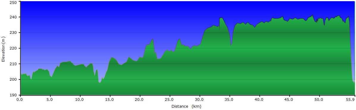
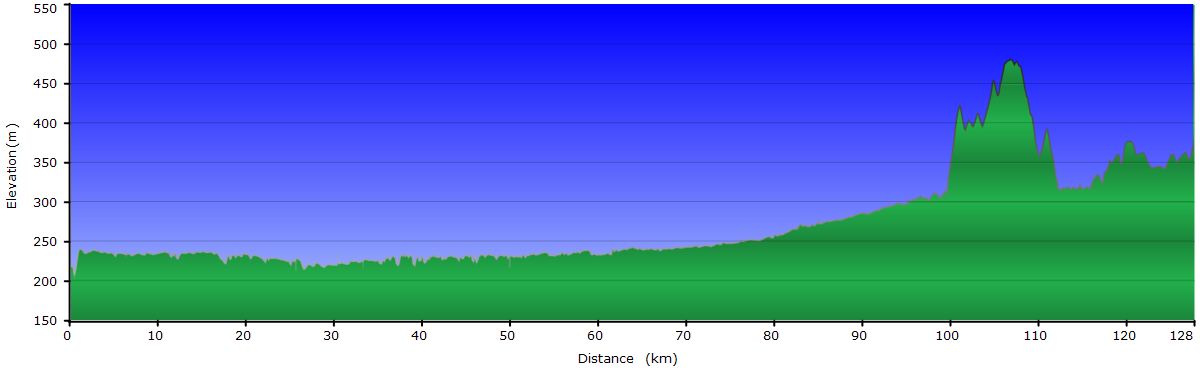
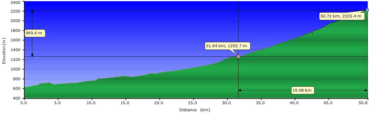
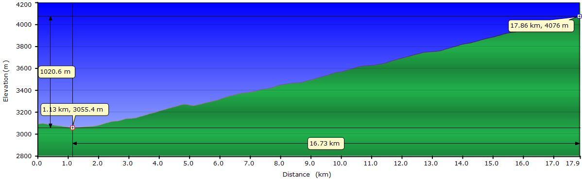
September 19, 2011: From Puerto Maldonado to Laberinto (Profile)
September 20, 2011: From Laberinto to Mazuko (Profile)
September 21, 2011: From Mazuko to Quincemil (Profile)
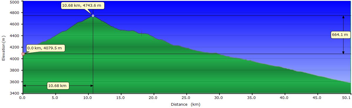
September 22, 2011: From Quincemil to Limacpunko (Profile)
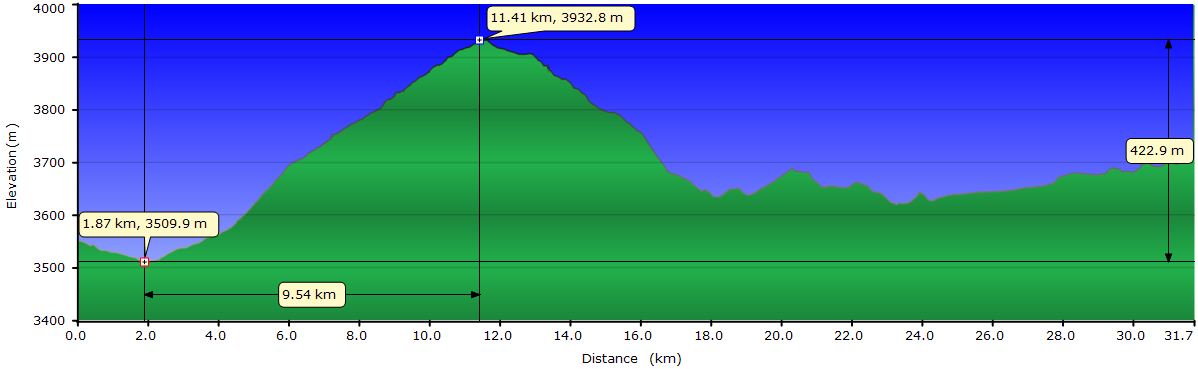
September 23, 2011: From Limacpunko to Marcapata (Profile)
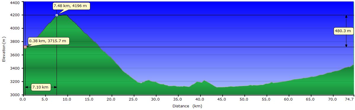
September 24, 2011: From Marcapata to Tambopampa (Profile)
September 25, 2011: From Tambopampa to Ocongate (Profile)
September 26, 2011: From Ocongate to Ccatcca (Profile)
September 27, 2011: From Ccatcca to Cusco (Profile)
Profile for the entire stage:

September 19, 2011: From Puerto Maldonado to Laberinto
Eventually we leave Puerto Maldonado. It seems every time we get to a city that provides services as a good hotel or restaurants we get stuck. But today, we leave before 7AM towards Puerto Rosario de Laberinto. Although the route is only 35 mi, we wake up at 5 AM because we still have to assemble the repaired wheel on the bike. While doing so we noticed that the brake pads are completely worn out and it has taken us some time to replace them and adjust the brake disc. Even as early as it is, the streets are filled with taxis, motorized tuk-tuks and moto-taxis. Traffic reduces considerably after passing the turn off for the airport.
 The paved road is quite flat, with few undulations, which allows us to ride faster than 13mph. The route is nothing special and in 3 hours we arrive in Santo Domingo, where the turn off that will take us to Laberinto is. The section of the inter-oceanic highway between Santo Domingo and Santa Rosa is dotted with gold mining settlements and apparently it looks a bit like the North American gold rush: it’s a lawless territory. Several people in Maldonado, including the police, have recommended we pass that stretch as quickly as possible and during daylight. That is why today we will sleep in Laberinto. We would stay in Santo Domingo, but the only accommodation does not meet our minimum requirements. So we ride to Laberinto on a dirt track, or rather, a rock track.
Laberinto is on the banks of the Madre de Dios River and gives the impression of being the supply center for the surrounding mines. At the port we see how the peke-pekes haul supplies, especially boxes of beer, going up and down the river. The best hotel in town is fully booked by the employees of the company that maintains the road. The second option also has all the rooms occupied and they don’t know yet whether any guests will leave today. It’s 10:30 and, according to the receptionist, some of the guests are still sleeping, drunk from last night. In the afternoon we get a room with bathroom. As extras we have a leaking faucet and a strong smell of paint.
We take a stroll down the streets and see a multitude of welding shops where they repair the mining machinery such as the pumps used in the dredges. On the street facing the river, businesses buying gold are side by side. After visiting the few streets, we go back to the room to build the elevation profile of the stages to Cuzco. In summary, we have to climb more than 16000 feet to reach the Andean highlands. Tomorrow we have 60 mi to ride with some pressure to pass them quickly so we go to bed early.
September 20, 2011: From Laberinto to Mazuko
 The night has been terrible. In addition to the slamming doors and screams of the other guests, we had to bear the blaring TV of the night receptionist. Luckily we are capable of sleeping on a fakir’s bed and we still got some rest. At 6 AM we are riding on the rocky track that will take us back to the inter-oceanic highway. After a few miles we find a couple of cyclists in the opposite direction. For months we haven’t seen any and we intercept them for a chat. Chris has been on the road for 16 months since he started in Alaska. Dimitri began in Quito. They both go to Ushuaia. After exchanging advice and recommendations for the next days, we keep riding.
After 30 miles, we find the first clusters of huts with plastic and palm leaves roofs. Most are welding shops or repair shops for motorcycles. We believe that the mines are at some distance from the road and the motorcycles are the means of transport used to reach them. From time to time, from the road we see tracts of land completely devastated by mining.
 After 60 miles we arrive to Santa Rosa, initial destination for today. The best accommodation is pretty seedy and we decide to travel the 18 mi that separate us from Mazuko, presumably with a greater offer of accommodation. Beyond Santa Rosa we have to overcome some hills. After several weeks of riding in the Amazon lowlands, today we meet again the foothills of the Andes. In brief we will suffer their full power.
At 80 mi we get to Mazuko, considerably larger than Santa Rosa, and find a satisfactory accommodation. After the shower we go out to buy some vegetables to prepare a salad for dinner. Tomorrow we will get up early again to avoid the heat, so we go to sleep soon.
September 21, 2011: From Mazuko to Quincemil
 Today we leave at 6 AM. The sky is overcast and it will continue so for much of the day. Definitely, the Amazonian lowlands are gone. We are in the area of rainforest, characterized by hills with steep slopes that make the road to meander along rivers loaded with sediments. These include the gold dust the miners are after in the numerous and precarious settlements we cross along the way. The vegetation is still lush, as in the jungle. In fact, we are still below at 1600 feet of elevation. The orioles are still common, like their hanging nests made from weaved twigs and straw.
And, of course, in the rainforest, it rains. By midmorning we get the first shower of the day. Fortunately we are near a roadside house and take refuge on the porch. We chat with the two men who inhabit it. They have 4 pets: 3 puppies and one yellow monkey with pedogfil tendencies. When the shower becomes a light rain, we resume the route. A few hundred yards later we find Edmilson, a Brazilian rider that spent the night in the house where we just took shelter. Edmilson is in a road garage trying to fix his bike and after offering help we arrange to meet in Quincemil at the end of the day.
 Later we get a second shower but we also manage to avoid getting soaked by protecting under the roof of what appears to be an abandoned wood shop. The third shower of the day finally soaks us. It begins about 6 miles from our destination and there is no cover in sight. It´s not cold and we are still pedaling in shirt and shorts. It's just uncomfortable cycling in the rain. When we arrive at Quincemil it’s raining cats and dogs. When we find lodging, the rain has stopped. I guess we had to get wet today.
In the afternoon the sky clears up and the sun shines bright. We go for a walk down the street of the village and meet with Edmilson again. We have dinner together and talk about our respective stories. He has been on the road for 5 years and a half traveling by bike. Besides the classic Alaska-Ushuaia, he has toured all Latin American countries. We will meet tomorrow at 6 AM to begin the climb to Cuzco together.
September 22, 2011: From Quincemil to Limacpunko
It’s raining again. Anyway, we load the bikes to be ready as soon as it stops. We agreed with Edi that if it rained we would wait until it stopped. Around 7AM it stops raining, we wait a bit to see if Edi appears. We don’t know where he is staying at so we finally leave without him.
 The road climbs from the beginning. Gently at first, but as the day progresses, the slope increases. Although it does it very gradually we can tell, because we have to use larger and larger cogs. The slopes of the mountains around us are becoming more abrupt. The vegetation is still lush, covers them completely. In the steepest hillsides, chained waterfalls jump hundreds of feet before reaching the valley floor. The river we follow is not like in the Amazonian lowlands, brown and quiet. This is fast and turbulent but with clear water.
The miles are left behind and we keep gaining altitude. A few gray clouds are chasing us, pushed by easterly winds, dragging all the moisture of the jungle. Right before we arrive to Limacpunko, they catch up with us. We wanted to get to Marcapata, but it starts to rain with intensity and we have already ridden more than 30 mi and almost 5000 feet uphill. Enough for today. When we enter Limacpunko, from one of the hotels by the road, comes out a guy screaming. This is Cesare, another rider who travels with his wife Regis, from Cuzco to Rio Branco, in Brazil. Cesare convinces us to stay at the same hotel they are. After settling, we go down to the downstairs restaurant and begin to exchange information. After a while Edi shows up pedaling and Cesare goes rushes out to intercept him and make him stay with us. We all go outside and for a moment we are the center of attraction for the villagers in a public display of exaltation of friendship.
September 23, 2011: From Limacpunko to Marcapata
 Another rainy day. Regardless of the weather, we load the bikes to be ready as soon as it stops. We planned to leave soon but start pedaling in the cold rain is too hard, so we wait in the restaurant with Edi, Cesare and Regis. Regis and Cesare know a shamanic method to scare the clouds away and go out to show it to us. It consists of blowing hard looking at the sky, moving their hands figuratively pushing the clouds out. Although they perform the ritual with great fervor, it looks funny to us. On the other hand, Edi wants us to stay one more day and makes up a witch ceremony for the intensity of the rain to increase. His method is even more funny. He goes outside with his fluorescent yellow jacket and with his arms outstretched toward the sky and his fingers tense, invokes the clouds while shaking violently and screaming spells in Brazilian. The truth is that with that bald head and his dark skin, he looks like a shaman in trance. Of course, we become once more the attraction of Limacpunko. The inhabitants of this village must think we are a troupe of comedians. Unfortunately for us, both methods work and cancel each other and the fine rain keeps falling exactly as before.
 A couple of hours later, the rain stops and we leave after a warm farewell. The road climbs without respite. At mile 10, we arrive to Marcapata, we have already climbed 3300 feet. The sky threatens us with rain again and we decide we have enough for today. After settling we go for a walk around the village. To our surprise, its location is superb. The cemetery is at the end of the spur of the hill that protects the village. The view from the cemetery is spectacular, no doubt a strategic point the Incas didn´t miss. From the lookout, we can see 3 valleys: the one we just went up, the one we have to go up tomorrow and a lateral one. At dusk, skinny clouds cover part of the steep slopes of the mountains that surround us. Along with a soft sun light, they create a mystical atmosphere. One can easily imagine the Inca priests performing the ceremonies of the empire in the small plateau at the graveyard. If Edi, Cesare and Regis were here, their rituals would have been much more solemn...
September 24, 2011: From Marcapata to Tambopampa
 Today is the second attempt to go over the Pirhuayani Pass. The sky is covered with gray clouds but no rain so far. After a gentle downhill, the slope goes up to a mathematically constant 6%. A few miles later, it begins to rain and we take shelter under a bridge. When it stops raining we resume the climb, but not for long before it rains again, this time with more intensity and for longer. We go under another bridge and wait there for a couple of hours.
Finally, we decide to leave our cover and ride to a cluster of houses named Tambopampa. We find a room to stay and since we have climbed our 3300 feet, we decide to stop. In another house we have a fried trout with potatoes. There, we share the table with two guys that come from the gold mines near Mazuko. Indeed, they have decided to leave that job and return to Quillabamba. Although they made money quite quickly, life among miners was too dangerous.
September 25, 2011: From Tambopampa to Ocongate
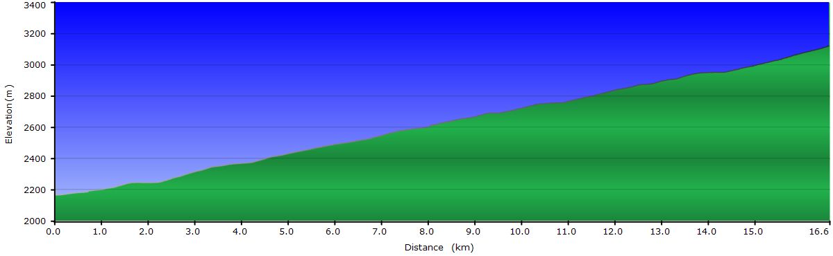
 Third attempt to go over the Pirhuayani Pass. We leave Tambopampa at 13330 feet of elevation. We only have 2300 till the pass, but at this altitude, everything happens in slow motion. Not sure if it´s the lack of oxygen or the lethargy caused by the cold, or both, but it takes us a while to ride the 7 miles to the summit. Once there, we go down at full speed. To our left is the Ausangate massif, the most important holy mountain in southern Peru.

Today is Sunday, and it´s market day in Ocongate. The residents of the surrounding attend the weekly event too buy food and other necessities. In the central square and surrounding streets stalls of fruit, vegetables and bread huddle along with other selling pots, shoes, wool, etc, etc. Many women wear their traditional costumes. The most striking are the colorful hats, flat and circular, decorated with curtains hanging from the edges, in addition to the typical bundle on their back. The busy streets of Ocongate are a burst of color. And best of all, this is not a touristy market, this is authentic.
September 26, 2011: From Ocongate to Ccatcca

 We keep accumulating miles and feet of altitude on our way to Cusco. Nothing worthy to report today.Since we crossed the pass, we have had sunny days and blue skies, only decorated by white big clouds. The landscape is now the typical of the Andean puna: only short shrubs and grass.
September 27, 2011: From Ccatcca to Cusco
 Ccatca is at the base of the last significant mountain pass before Cusco. After 1600 feet uphill, a descent of over 3300 feet takes us to the main road linking Puno and Cusco, on the outskirts of the village of Urcos. The traffic from this point to Cusco is much denser. En route we meet Atsushi and Yoko, two Japanese riders that just today started their trip in Cusco. Yoko ends her short tour in La Paz, but Atsushi continues till Ushuaua.
Arriving into Cusco is stressful, mainly for the traffic and the many miles crossing the surrounding cities, but we have finally reached the capital of the Inca Empire. We stay in Cusco for a few days visiting the narrow streets of the San Blas neighborhood, the famous stone of 12 angles and other prominent landmarks.
On a planned trip with our parents, next month we will visit the archeological sites around Cusco, as well as the Sacred Valley and, of course, Machu Picchu. This will be our second time in Ollantaytambo and Machu Picchu but we got as impressed as the first time, a few years ago. It’s unbelievable the skills and knowledge of the Incas to build these wonders.
