Sequoia NP:
• Sequoia NP
• Sequoia Natural History
Association
Avalanche forecast:
• Avalanche Center
• Avalanche.org
• Sierra Avalanche Center


This is a 3 day activity in the Sequoia National Park but day 2
is optional.
Day 1: From Wolverton to Pear Lake Ski Hut
Download the GPS file
Day 2: Tableland Crest Tour
Day 3: From Pear Lake Ski Hut to Wolverton
Additional Day: Winter's Alta Peak
Download the Waypoints file
Day 1: From Wolverton to Pear Lake Ski Hut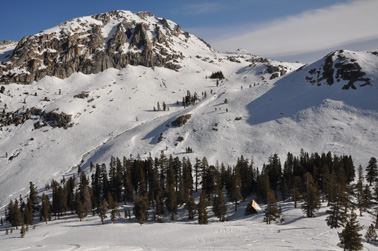
Facts:
Distance: 4.5 miles
Altitude at starting point: 7225ft.
Altitude at destination point: 9175 ft.
Elevation gain: 2640 ft.
Total descent: 605 ft.
Duration: 5 h. (at slow pace)
Date: 03/27/2010
Gear: Alpine touring
This route starts at the Wolverton Picnic parking area and climbs “The Hump” to get to the Pear Lake Ski Hut (managed by the Sequoia Natural History Association, SNHA). Depending on the year, the snow coverage at the beginning of the trail may not be good. It is common to find a lot of small branches on the snow surface. Since most of this section is in the shade, the snow is also hard and/or icy. Although this is a relative short day, the climb to the top of the Hump is steep, so plan accordingly. Coming down from the Hump, you will cross the Heather Lake. After, the trail goes up and then down passing close to the Aster Lake. Then it gets closer to the drainage of the Marble Fork of the Kaweah River traversing towards the Hut.
Yellow reflective triangles on trees mark the trail. The route is pretty well marked up to the Hump. However, the traverse after the Aster Lake is an open space and marks are far apart. Just get around the spur without loosing too much altitude. The hut is somehow hidden in a small wood area very close to the stream. You shouldn’t have too many problems finding your way to the hut under good weather conditions.
Description of the route:
This route begins at the Wolverton Picnic area parking (WH01 TrailHead). The trailhead is right next to the bear boxes. Actually two trails begin here, the Wolverton (marked with a “W” on the yellow triangles) and the Pear Lake trails. If there is enough snow start with your skins on. After 500 ft, the Pear Lake trail splits to the right (WH02 GoRight). Follow the marks that will take you through the forest. At the beginning, you will be skiing on the bottom of the small valley. Farther on, the trail shifts to the top of the ridge on your left hand side. At mile 1.1 from the start, turn right (WH03 GoRight); 0.1 miles later there is another right turn (WH04 GoRight).
At mile 1.3 you’ll arrive to the Panther Gap trail fork (WH05 PantherJunction). Follow the signs that climb the open area to your left. This is the beginning of the Hump. At mile 1.6 the trails moves to another valley and goes down a little bit and back uphill (WH06 Down). The route proceeds through the bottom of this new valley but at mile 1.9 climbs up the ridge on the left (WH07 OnRidge). At mile 2.0 veer left slightly and keep following the triangles (WH08 GoLeftSlight). 0.1 miles later make a sharp turn to the left (WH09 GoLeft&Flank) and go around the hill. Short after that (at mile 2.2) you should cross a stream (WH10 XStream). Be cautious about where you cross it.
 At
mile 2.9 you reach to the top of the Hump (WH11 Top&Viewpoint).
Take your time to enjoy the view (see panorama above). The river at the bottom
of the valley is the Marble Fork of the Kaweah River. The trail goes down the
Hump on your right hand side. It’s not worth it to pull your skins off since the
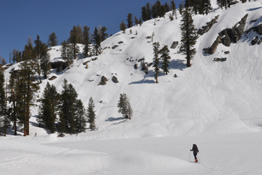
downhill is short. At mile 3.2 you will cross the Heather Lake and go up a little
hill (see picture to the right). Then a longer downhill takes you to either the
Aster Lake or its outflow creek. This route crosses the creek at mile 3.8 (WH12
XStream). From here choose your own path to go around the spur without
loosing altitude. At mile 4.5 you should arrive at the hut (WH13 Hut).
At
mile 2.9 you reach to the top of the Hump (WH11 Top&Viewpoint).
Take your time to enjoy the view (see panorama above). The river at the bottom
of the valley is the Marble Fork of the Kaweah River. The trail goes down the
Hump on your right hand side. It’s not worth it to pull your skins off since the
downhill is short. At mile 3.2 you will cross the Heather Lake and go up a little
hill (see picture to the right). Then a longer downhill takes you to either the
Aster Lake or its outflow creek. This route crosses the creek at mile 3.8 (WH12
XStream). From here choose your own path to go around the spur without
loosing altitude. At mile 4.5 you should arrive at the hut (WH13 Hut).
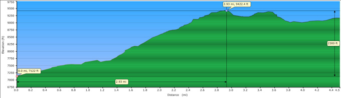
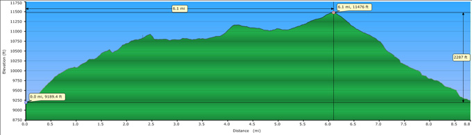
Profile from Wolverton to Pear Lake Ski Hut.
Day 2: Tableland Crest Tour
Facts:
Distance: 8.8 miles
Altitude at starting point: 9175 ft.
Altitude at destination point: 9175 ft.
Elevation gain: 2500 ft.
Total descent: 2500 ft.
Duration: 7 h 50 min (moving: 3:40, stopped: 4:10).
Date: 03/28/2010 Gear: Alpine touring
This route starts at the Pear Lake ski Hut, climbs to the Tableland meadows area and tours the crest around the meadows cirque. Along the crest, it summits the flat Tableland peak (on the border between Sequoia and Kings Canyon National Parks) and then goes West to the top of the crest (unnamed peak). From there, the downhill follows a short but fairly steep SE facing slope dotted with rocks. After some traversing, it finally goes down to the hut. Ask for avalanche conditions to the hut keeper.
The views along the crest are magnificent. You can see all the way from the Alta peak and Winter’s Alta to the distant Table Mountain and surrounding peaks. On the second half of the tour the expansive vistas towards the Kings River only get obstructed when you plunge into the adrenaline-releasing downhill.
Description of the route:
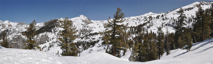
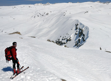
Put your skins on and leave the Pear Lake Hut (TL01 Hut) towards the Pear Lake. Cross the stream at a safe place (TL02 XStream), zigzag your way up leaving the Matterhorn to your right and crossing to the other side of the pass. This is good spot to check the steep downhill at the other side of the drainage that this route will use to ski down the crest (see picture below).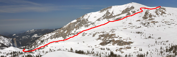
From here there are two ways to reach the Tableland peak: drop to the main drainage and follow the Marble Fork Kaweah River upstream or traverse the bowl towards the East. This route chooses the latter. It flanks the bowl gaining some altitude to get to a lake (TL03 Lake) at mile 1. Here, you can follow the drainage that feeds this lake and the ones chained upstream or go around the two hills to the NE. This GPS track follows the second option but this implies dropping down after you summit the second hill. Regardless of the alternative selected, arrive at the weather station at mile 1.9 (TL04 WeatherStation). From here, head towards the peak at the NE leaving two small lakes to the right and flanking between the rocks. When you arrive to the pass turn East and climb to the peak at the top of the cliff (TL05 TopCliff) at mile 2.6. This is a good vantage point to check the rest of the route and see the Table Meadows below. Drop to the top of the cliff (see picture below) and follow the ridge NE.
 At
mile 4.2, reach the flat top of the Tableland peak. Cross on to the Kings Canyon
NP and get close to the viewpoint (TL06 SeqKingsDiv). This is
a good spot for lunch. To continue, follow the crest in NW direction until the
next summit and highest point of the loop (TL07 TopCrest) at
mile 6.1. When approaching this peak the crest on the last stretch can be a little
intimidating from below when approaching it. It seems like there is a cornice
on the other side of the ridge but that side of the mountain is wide and not very
steep.
At
mile 4.2, reach the flat top of the Tableland peak. Cross on to the Kings Canyon
NP and get close to the viewpoint (TL06 SeqKingsDiv). This is
a good spot for lunch. To continue, follow the crest in NW direction until the
next summit and highest point of the loop (TL07 TopCrest) at
mile 6.1. When approaching this peak the crest on the last stretch can be a little
intimidating from below when approaching it. It seems like there is a cornice
on the other side of the ridge but that side of the mountain is wide and not very
steep.
When you arrive at the top, drop a little from the flat top to the rocky outcrop and select your line of descent (TL08 SkinsOff). Pull your skins off and ski down between the bristlecone pine trees aiming for the rocks located at mile 7.0 (TL09 Rocks). The next waypoint is at the top of the steepest section (TL10 Steep). This is the most dangerous part of the loop. The next 150-200 feet are steep, dotted with rocks and the creek running down is buried under the snow. The line that seems clearer of rocks crosses over the stream a couple of times. Judit broke the snow bridge over the creek once. This is a SE aspect, so the snow would have warmed up by the time you get here. That means softened snow if it was hard or icy but more chances of avalanches. Check the avalanche forecast and with the hut keeper.
After you go down this steep section, traverse to your right without loosing too much altitude. Your goal is to cross the Marble Fork Kaweah River at mile 8.4 (TL11 XStream). After the crossing at a safe place, keep flanking now with the mountain on your left. The Hut should be in sight down at the valley when you get to the other side of the bump. Ski down, cross the stream at a safe place and get to the Hut at mile 8.8 (TL12 Hut).
Profile for the Tableland Crest Tour.
Day 3: From Pear Lake Ski Hut to Wolverton
Facts: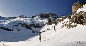
Distance: 4.5 miles
Altitude at starting point: 9175 ft.
Altitude at destination point: 7225 ft.
Elevation gain: 605 ft.
Total descent: 2640 ft.
Duration: 2 h 50 min.
Date: 03/29/2010
Gear: Alpine touring
This route starts at the Pear Lake Hut and ends at the Wolverton picnic area. The route is the opposite of the one on day 1 and follows the same path, except for a slightly different way to climb the Hump.
Description of the route:
With your skins off, leave the hut (HW01 Hut) and traverse loosing as little altitude as possible. After 0.5 miles put them on (HW02 SkinsOn) and climb towards the Aster Lake. Trail signs are sparse in this area. One is at 0.6 miles at HW03 TreeSign. Keep moving towards the stream outflow from the Aster Lake and cross it at mile 0.7 (HW04 XStream). Here is where the climb to the Hump begins.
 Take a West direction to find another trail sign at mile 1 (HW05 TreeSign).
The next one is at mile 1.1 (HW06 TreeSign). Keep following them
and start crossing the Heather Lake at mile 1.3 (HW07 XLakeBegin).
End crossing it at (HW08 XLakeEnd). At mile 1.5 is where the
steep section up the Hump begins (HW09 HumpClimbStart) and the
top is reached at mile 1.6 (HW10 HumpTop).
Take a West direction to find another trail sign at mile 1 (HW05 TreeSign).
The next one is at mile 1.1 (HW06 TreeSign). Keep following them
and start crossing the Heather Lake at mile 1.3 (HW07 XLakeBegin).
End crossing it at (HW08 XLakeEnd). At mile 1.5 is where the
steep section up the Hump begins (HW09 HumpClimbStart) and the
top is reached at mile 1.6 (HW10 HumpTop).
Take your skins off and head down following the trail signs. Cross the stream at a safe place at mile 2.2 (HW11 XStream). The path is easy now, just follow the signs. Pass the Panther Gap junction and veer left at mile 3.5 (HW12 GoLeft). Very close to the trailhead you will find the junction with the Wolverton trail. Go left (HW13 GoLeft) and arrive at the parking lot at mile 4.5 (HW14 Parking).
from Pear Lake Ski Hut to Wolverton.