Download GPS files for Roaring River Loop:
• GPS track & waypoints
Photo album:
• Roaring River Loop
Sequoia NP:
• Sequoia & Kings Canyon NP
• Backcountry permits
Eating:
• Monet's (Exeter, 559-592-9453)
 Roaring River Loop
This adventure is a 4-day hike in the Sequoia and Kings Canyon National Parks.
Day 1: From Wolverton to Bear Paw campground
Day 2: From Bear Paw campground to Deadman canyon
Day 3: From Deadman canyon to before the Silliman Pass
Day 4: From before the Silliman Pass to the Lodgepole Visitor Center
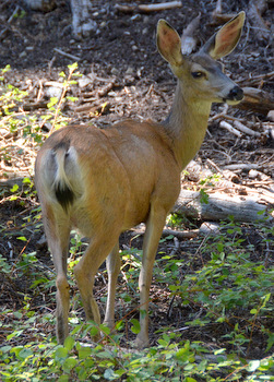
This adventure starts at the Wolverton trailhead in Sequoia NP and crosses over the Elisabeth Pass to enter the Kings Canyon NP. After following the Roaring River for some miles, it climbs over the Silliman Pass to go down to the Lodgepole Visitor Center back in the Sequoia NP. We didn’t spot much wild life, just a few mule deer around the Bear Paw campground.
This loop covers part of the High Sierra Trail (HST) and the views when above the timber line are spectacular. The hike along the U-shaped Deadman Canyon is particularly rewarding both looking downstream and upstream. Other beautiful stretches worth mentioning are the first couple of miles after the Bear Paw camp where the trail goes around a rocky spur and the area before the Silliman Pass.
The climbs to both passes are strenuous but the Silliman Pass is a lot easier than the long and steep Elisabeth Pass. The first day and specially the Bear Paw campground where a little crowded compared to the rest of the days. The route can be done in both directions. In total it’s 52.8 miles, 11500 ft. of elevation gain and 11900 of descent, making it a hard hike for 4 days, when done counter clockwise.
Roaring River Loop elevation profile.
Day 1: From Wolverton to Bear Paw campground
 Facts:
Distance: 11.1 miles
Elevation gain: 2600 ft.
Total descent: 2160 ft.
Duration: 7:25 h.
Date: 08/30/2014
Description of the route:
This hike starts at the Wolverton parking lot and follows the Alta trail for a few miles. The first section is familiar to us since this is the same trail we use to go to the Pear Lake Hut in winter (see PearLake). The new part starts at mile 1.8 when we leave the trail to the Hut on the left. This first section is covered by dense forest.
From the Panther Gap (mile 2.8) there is a nice view of the Castle Rock, a group of sharp peaks across the Middle Fork of the Kaweah River. The trail keeps going up until mile 3.8 for a total elevation gain of 1675 ft. from the trailhead. Take a left here and drop 1150 ft. in 2.1 miles to the High Sierra Trail. Take another left. Once on the HST, we have a good view of the Little Blue Dome and the Sugarbowl Dome. From here, the terrain goes up and down for the next 3.7 miles with a total loss of 450 ft. This is the lowest point of the day, the crossing of the Buck Creek (there is a bear box here).
When we are at the top of the last uphill (mile 10.9) before the Bear Paw campground, we spot a mule deer. He doesn’t seem scared and carries on foraging checking on us from time to time. After enjoying the encounter for some time, we finally walk by his side and continue on.
The Bear Paw campground is to the right of the trail, down the hill (mile 11.1). There are quite a few sites and a faucet with untreated water. While setting up the tent, another deer shows up walking among the campsites. During that evening we saw several solitary deer and a family of 2 adults and 2 young close by.
Profile from Wolverton to Bear Paw campground.
Day 2: From Bear Paw campground to Deadman canyon
Facts:
Distance: 10.3 miles
Elevation gain: 4360 ft.
Total descent: 2735 ft.
Duration: 13:24 h.
Date: 08/31/2014
Description of the route:
There are two ways to get out of the Bear Paw campground: the way we came down yesterday and another trail that joins the main trail closer to the HST camp. There are also 2 ways to get to the Elisabeth Pass from the campground. The shorter way starts between the two junctions on the main trail that go down to the campground. Although shorter, this option goes first up and then down to meet the second option. This second option is longer since it goes around the hills following the valley but has less elevation gain. We choose the longer one and therefore start the day going back to the main trail on the second branch out of the campground.
At the junction with the main trail (0.16 miles, Go Right), Guillaume catches up with us and we hike together for a few miles. We first cross the HST camp and follow the trail on a beautiful stretch along a cliff with the valley at the bottom and the high sierra on the other side of the valley in front of us. The sun is rising over the tallest peaks but some grey clouds still cover them and let only some sun rays go through. Guillaume is crossing the sierra from West to East but with a twist. Instead of following the classic HST, which would make him climb the Elisabeth Path with us, he is going through a different pass he saw on the map. The rangers call that pass the Bad Piss-Your-Pants Pass. Instead, they suggested him using another one close by that they call the Good Piss-Your-Pants Pass.
From the bridge over the Lone Pine Creek (mile 1.8) we can see a pass upstream. We are thinking that’s the Elisabeth Pass but it’s not, it’s farther to the right. Short after the bridge, we split (mile 1.9). Guillaume goes right toward the Hamilton Lake and we go left towards the Elisabeth Pass. The climb starts right away and it will continue till the top of the pass (total of 4.7 miles and 4000 ft. from the last junction). The first steep section is the one next to the waterfall we saw from the bridge but we are still fresh and it’s not too bad. Once on top of the waterfall, we see the shorter trail coming from the campground going down to join our route. They merge right at the other bank of the river. We are now over the timber line.
Although there is a cairn on the granite ledge on the stream bed, this is probably no the official crossing of the river. We can see a trail sign (mile 3) on the other bank so we decide to cross here and continue towards the pass. At mile 3.2 we find another trail sign where a trail joins ours from the right. That trail comes from the Tamarack Lake and this is probably the official point where the shorter and longer trails mentioned at the beginning of the day join.
The slope becomes steeper and we have to stop several times to rest. The last spot where we saw running water was at mile 4.6. After crossing this stream, the trail turns East and we realize that the pass we thought was the Elisabeth is not. The trail goes up relentless. We need to look for the cairns to follow it since it becomes sketchy in some stretches. The last section to the top is a series of switchbacks on a classical scree. We reach the pass at mile 6.6 and 4275 ft. of elevation gain from the campground. The elevation of the pass 11378 ft.

From the pass we can see both sides of the divide and all the sharp peaks that from the crests. This is also the border between Sequoia and Kings Canyon National Parks. The trail down the pass is very rocky with granite rocks the size of a tennis ball. That particular size that makes your foot shake before settling. The terrain doesn’t improve much until we reach the bottom of the valley where it has long stretches of grass, dirt and fine gravel. The slope is definitely not as steep as the Sequoia side. At mile 8.2 from the beginning and 1000 ft descent from the pass is the first spot where we can filter water after the pass. The trail keeps going down and we cross the stream we are following. Right after that crossing (mile 8.7) there is nice place for a campground, on a granite ledge. That site has very nice views of the pass and the Deadman canyon. It’s also a convenient spot to spend the night and attack the pass if you are going the other direction. We keep going down and reach a drop that will take us to the bottom of the valley through a series of sharp switchbacks. Once at the bottom the trail flattens.
We are really tired and set as a goal to reach the first set of pines about a mile away. Just before the first pines we see a huge flat granite ledge with the creek running on it and decide to stop there for the night. The views down and up the canyon are excellent and the sun is still illuminating the crest so we decide to take a bath on a pool about 10 inches deep. This is much better than last night at the crowded Bear Paw campground. Tonight we have the entire valley for us. This is why you hike for several days, to get away from everybody and enjoy nature by yourself.
After preparing diner we get close to the creek to filter water and we see a tiny trout trying to swim upstream but the water is so shallow that more than half of its body is out of the water. It struggles moving its tail vigorously but it doesn’t work too well when there is no water to push on. Eventually, it goes downstream to a slightly deeper spot to rest, recover and try again. It’s determined to get to the pool upstream.
Profile from Bear Paw campground to Deadman canyon
Day 3: From Deadman canyon to before the Silliman Pass
Facts:
Distance: 17.7 miles
Elevation gain: 2080 ft.
Total descent: 3100 ft.
Duration: 11:35 h.
Date: 09/1/2014
Description of the route:
We are behind schedule respect to the original plan which was to have spent the night close to the Roaring River Ranger Station. Today we need to catch up some of that or tomorrow is going to be a very long day and we still have to cross the Silliman Pass before hiking down to the Lodgepole Visitor Center.
When we are almost ready to start hiking, the sun line is barely hitting the West ridge of the valley. Pretty soon we enter the first pine forest. The combination of the different trees species, the tall grass and the flowing river makes a nice contrast with the rocky and stark environment of yesterday. The terrain is very compact and the slope gentle so we can make good progress. At mile 2 we reach the Ranger Meadow where the grass is already withering and turning yellow. We can see a cabin on the other side of the creek and we are guessing that’s the ranger’s cabin. Looking back we can still see the cirque at the head of the valley. The combination of the golden grasses, the granite peaks now illuminated by the sun and the blue sky make a nice postcard. At some point we think doing the loop on the other direction may be better to enjoy the views of the valley head but it’s also true that when you go uphill, you hike head down a good percentage of the time and can’t enjoy the views anyway.
The trail follows the creek all the way to the Roaring River Ranger Station and except for some stretches is smooth and firm. On one of the river crossing we hear some broken branches and we see 2 bears, one of them climbing down in a hurry from a tree trunk. After that, the only thing we can see is a furry ball running away in the tall grass.
There are plenty of spots to camp along the way. The ranger station is at mile 7.5, at the confluence of the creek we are following and the Roaring Creek. We write down our names on the logbook and take the leftmost trail towards the Silliman Pass. We follow now the Roaring River still on a gentle downhill until mile 9.2 from last night campground. At this point, we need to overcome a 400 ft. uphill to hike down the same elevation and meet the Ferguson Creek where we filter water (mile 10.5). We are not filling up all the containers we have since we know there are several other streams where we can take water from and we don’t want to carry the extra weight.
This area is drier and the terrain becomes sandy and dusty. It will stay like this well after passed the Sugarloaf rock at mile 14. Here is where the uphill towards the pass begins. There is a bear box nearby. Except for the steep section at mile 14.5, the majority of the uphill is very doable and we don’t stop much. Some of the creeks on the map are totally dry and we keep measuring the water we will need until the next main source of water. The only wildlife we see in this section is a quail that shows up on the trail for a split second.
After that section, comes an area of burned trunks. Some are still standing but most are fallen. A new generation of young trees is growing in between the abundant grasses. These are so abundant that the trail is faint on some short stretches.
At mile 15.5 we reach the Comanche Meadow (bear box nearby) and decide to keep on at least until the next junction where we should find water. At mile 16 we turn left looking for the stream and find it still running but very low flow. The pool just upstream has abundant algae and the small trouts don’t have to fight much to stay put. A few yards after, there is a clearing in the forest and we decide to stop for the night. The next source of water is the Ranger Lake, 3 miles ahead and 1200 ft. in elevation gain. We feel like it’s a task for tomorrow. Our feet, shoulders and waist are sored after the 17.7 miles we have hiked today.
Profile from Deadman canyon to before the Silliman Pass
Day 4: From before the Silliman Pass to the Lodgepole Visitor Center
 Facts:
Distance: 13.7 miles
Elevation gain: 2450 ft.
Total descent: 3900 ft.
Duration: 8:15 h.
Date: 09/2/2014
Description of the route:
Last night camp wasn’t particularly pretty but was a good decision since the trail starts to climb after a few yards. The forest has an interesting mix of trees and boulders and the trail winds smoothly around and between them. It’s still early, the tree shadows are long and the glare of thelow angle sun blinds us. As we make progress, we reach the top of the hill before the Ranger Lake. There are good spots for camping before and after the top. We arrive to the lake junction (mile 3.5). The view of the lake is beautiful from the drainage. The reflection is perfect. At the opposite shore, the line of trees is backed up by some boulders and the blue sky. The water level is so low that there is no running water flowing down the spill out.
After the Ranger Lake, the trail climbs again. Here the trees are sparser and the granite rock takes over. At mile 4.5 there is a good lookout point from where both the Ranger and the Beville Lake can be seen from above. The trail keeps climbing weaving between boulders until the Silliman Pass (mile 5.4, altitude 10171). From there a series of steep zig-zags will take us to the Twin Lakes (mile 6.7) where we refill our bottles. At mile 8.7 we merge with another trail coming from the J. O. Pass, go left and start a short climb of 250 ft (mile 9.4). From here is all the way down to the Lodgepole campground at mile 13.7. Here we took the shuttle bus to the Wolverton parking lot.
Profile from before the Silliman Pass to the Lodgepole Visitor Center.


