• Logbook
• Road Stars
Photo album:
• Austral Road
Download GPS file from El Chaltén to Villa O'Higgins crossing:
• GPS track & waypoints
Lodging and eating:
• Hospedaje del Río (Caleta Tortel)
• Ada´s Café Restaurant (Cochrane)


In this stage we ride part of the famous Chilean Austral Road. Riders usually start in Puerto Montt and finish in Villa O'Higgins but we are going on the reverse direction. As we already rode on this area a few years ago, this time we've decided to see the Argentinian side of the Andes. Our route begins in Villa O'Higgins and runs North along the Austral Road, but we divert to Chile Chico to cross the Andes towards Los Antiguos, in Argentina. Along the way we make a couple of detours, one to Caleta Tortel and the other to the Chacabuco Valley.
Stage index:
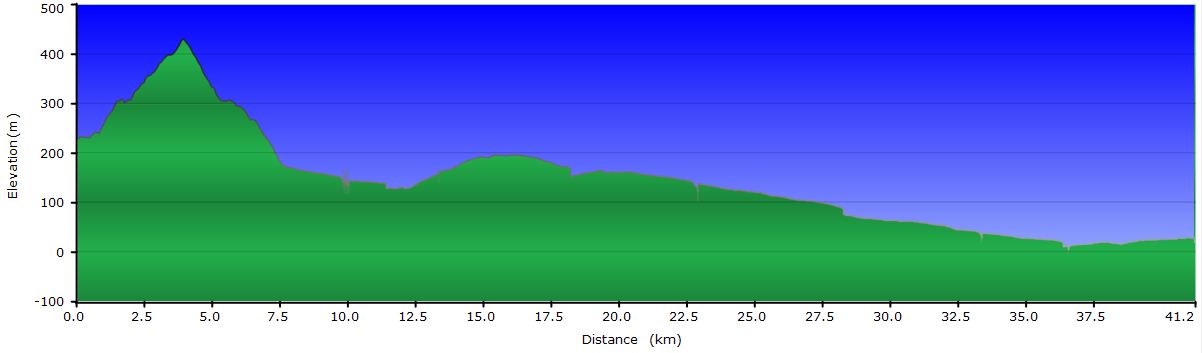
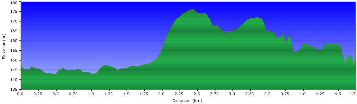
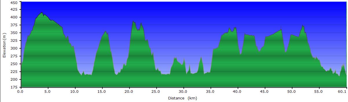
March 27: From Villa O'Higgins to Río Resbalón (Profile)
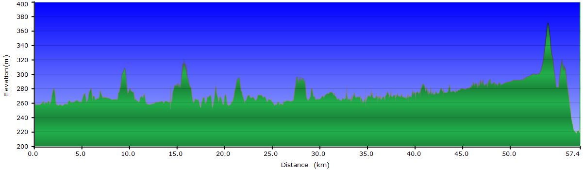
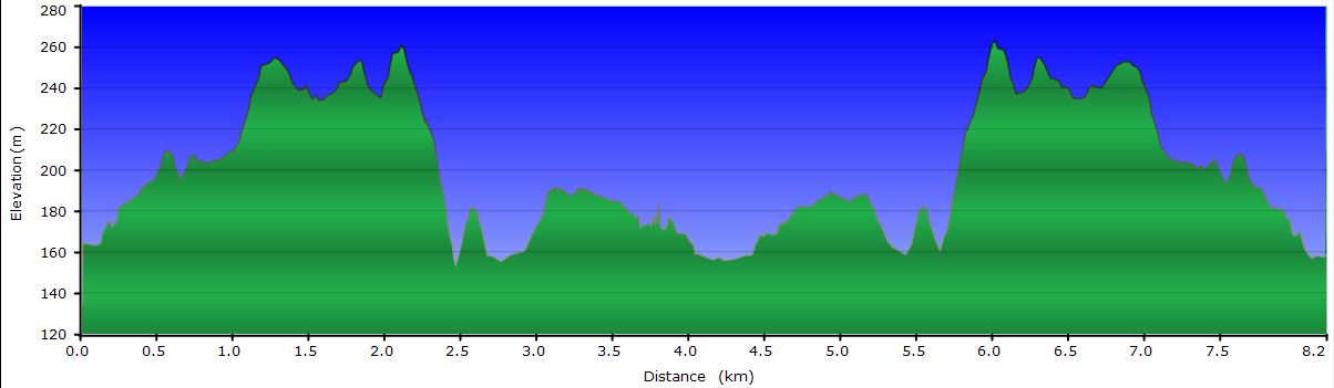
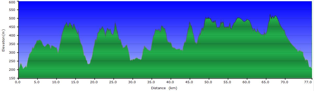
March 28: From Río Resbalón to Caleta Tortel (Profile 1st part) (Profile 2nd part)
March 29: From Caleta Tortel to Cochrane (Profile)
March 30: From Cochrane to Tamango National Reserve (Profile)
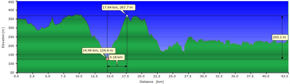
March 31: From Tamango National Reserve to Estancia Chacabuco (Profile hike) (Profile bike)
April 1: Visit to Valle Chacabuco (Profile)
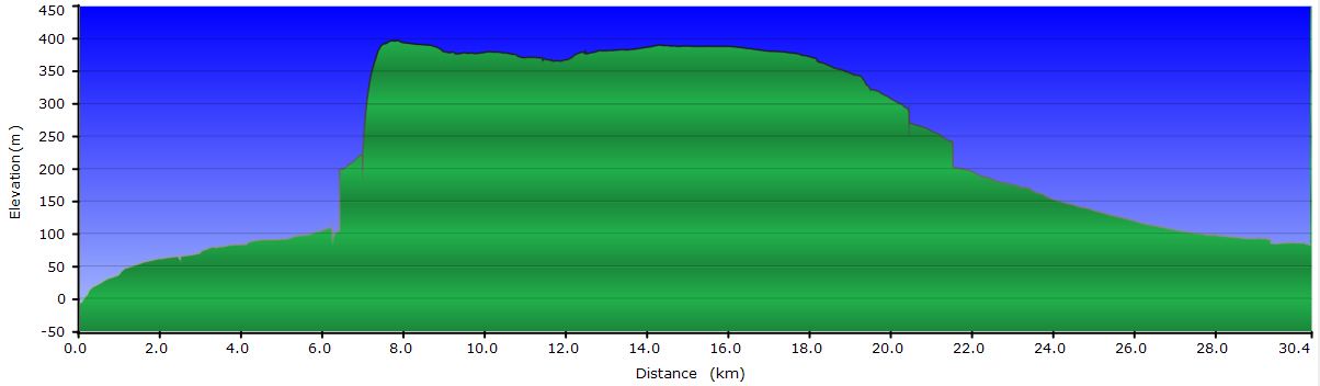
April 2: From Estancia Chacabuco to Puerto Bertrand (Profile)
April 3: From Puerto Bertrand to Mallín Grande (Profile)
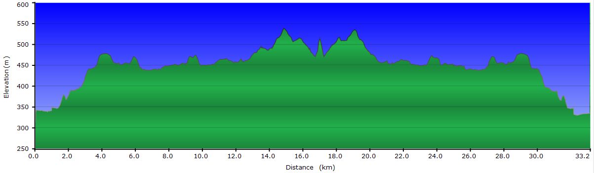
April 4: From Mallín Grande to Chile Chico (Profile)
April 5: From Chico Chile to Perito Moreno(Profile)
March 27, 2011: From Villa O'Higgins to Río Resbalón
Villa O'Higgins is a small village and doesn´t take more than 10 minutes to visit it on a bike, enough to get an impression of it. It has new public buildings such as the library and the gym, along with a potpourri of different looking houses. It seems that people enjoy multiple government subsidies to encourage permanence.
Adding up the short visit, the time to buy food and especially the time spent chatting with Paquita and Jorge, we end up leaving at noon. Our first stop is at the mouth of Lake Cisnes where everybody says fishing is a piece of cake. We stop on a beach below the bridge and while Judit reads I try my chances with the trouts. After 45 minutes and losing a couple of hooks, an SUV drives down to the lakeshore. Dad and his two girls start fishing a few yards away from us. When the father realizes he has left the car headlights on, he starts the engine and steps on the gas to charge the battery. The wind brings me all the fumes and despite my complaints he continues with his stupid goal. After a few minutes I´m pissed off and pick up the gear and congratulate him for his respect for others. Not only he doesn´t give a dime but also his chubby daughter just caught a nice trout. Pissed off and green of envy, we get out of the place.
 The road at first skirts several lakes, but later both sides are covered by a giant pit bog that extends towards the foothills. The truth is that it doesn´t surprise us that there is so much water. In addition to all the rain that falls in the area, from the snowy peaks run down countless streams and waterfalls that flow into the plain of the valley. The river cannot drain all that amount of water into Lake O'Higgins and it floods the plain. The gravel road breaks the homogeneity of the landscape, and although it allows us to move through the region, it´s clearly perceived as artificial and misplaced.
The rain falls intermittently and with varying intensity. Sometimes it combines with the wind to hinder the progress and make us question if we should stop pedaling for today. In the end, it’s a steep climb that makes us camp on a flat area on the banks of the Río Grande, just where it joins the Río Resbalón.
March 28, 2011: Del Rio Resbalón to Caleta Tortel
The road north ends at the Mitchel Fjord, where a government barge crosses vehicles and passengers for free four times a day. We want to cross at 1, because the next is at 4 and that would prevent us from reaching Caleta Tortel before dark. The problem is that we still have 25 mi from the port, it's been raining non-stop for hours and we don´t find the courage to leave the tent. By 9 we have no choice but to get going, so we pack everything as fast as we can and start pedaling.
We are covered from head to toes in waterproof clothing, but everything has a limit. The first thing is to fail are the gloves, after the gators and boots, followed by the pants and the gore-tex jacket. You only need to come to the Austral Road to verify that the gore-tex is a scam. I don’t know if we are wet from rain or sweat, but for practical purposes it’s the same.
Even with the reduced visibility the rain allows, the views from the road are incredible. Dozens of waterfalls rush down from each mountain. Some with a lot of water; others come to the road and go through the pipes under it with a thunderous noise. Seeing the amount of water flowing, we are not surprised to find the remains of landslides in sections where we approach the foothills. After a couple of days, the road will be closed for days due to flood, leaving Villa O'Higgins cut off by land.
We ride the 25 miles to the harbor in about 3 hours. It would have taken us a little less if it weren’t for the cows. In the last part of the road before reaching the fjord, lush vegetation has replaced the pit bog. Occasionally, we find a few cows grazing on the narrow shoulders separating the gravel from the tree, shrubs and bamboo walls. The cows panic when they hear us coming and run forward. The situation is as follows. Our ferry leaves in half an hour and we still have a few miles to reach the port. We cannot slow down, but the cows are running slower than we ride and have no space on the shoulders to get off the way. And if they do, they are so stupid to pass them by. You can imagine us chasing them while they look back every so often to find out that we are still there. They get scared again, accelerate momentarily and switch to the other side of the road. From behind we yell at them as if we were cowboys to keep them running until some open space in the vegetation or to make them go down to the shoulders. Sometimes they stop from exhaustion, turn around and stand up, making us slow and even stop. Finally, they reach a moment of desperation and in an instant of wrath they jump into the ditch to stop the endless chase. Freed of the caw jam, we resume our cruising speed while some of them moo from behind as one would honk to the typical impatient driver that passes you in a blind curve.
We finally arrive at the harbor about 15 minutes before time, enough to eat some cheese sandwiches and biscuits in the shelter next to the ferry ramp. We would also like to wring the gloves and let the waterproof gear drip. A few minutes later the bus that left Villa O'Higgins this morning arrives. It carries all the tourists we met at Candelario Mancilla, in addition to Paquita and some locals. It’s completely full, so even if we wanted to get on to give up riding in the rain, it is not possible.
When we reach Puerto Yungay, on the other side of the fjord, we go to the harbor’s kiosk to have a coffee and a steaming hot chocolate. During the ferry ride we decided to stay and sleep in a crumbling building next to the port that other cyclists told us days ago. After a couple of hours at the bar, our bodies have recovered 98 degrees and given how unattractive Puerto Yungay is, we get back to pedal in the rain. We only have 27 mi more to Caleta Tortel, the nearest village.
The hills from the port to leave the valley of the fjord are an agony, but once we reach the upper area, the road levels out. This is the area where we enjoy the views the most. Between clouds and the water curtain one can guess a wild terrain where water has no choice but to jump into the void from the glaciers to reach the valley. For several miles we ride a roller coaster where the civil engineers did their best to negotiate the orography. Finally we find the downhill that leads to the junction to Caleta Tortel. At this point our fingers are numb and we're ready to camp next to the bulldozer near the intersection. The signal indicates 14 mi to Tortel and in a display of courage we decide to keep cycling with the hope of reaching an accommodation with hot shower before dark.
Although the terrain is flat and in fairly good conditions, we realize we will not get there on time. However, our determination will be rewarded. When we are 8 mi from Tortel, a small truck with open trunk passes us. It is our golden opportunity. While keeping the balance with one hand on the handlebar, we wave the other furiously to catch the attention of the driver. Unfortunately the brake lights do not turn on... At least until after the next corner! Hector and his co-pilot help us to load the bikes behind. When we ask how to tie them to the railings they respond with all obviousness that we will hold them. We had not realized that the cabin does not fit more than 2 people! We almost would have preferred to finish the bike ride than the truck. With one hand we cling to the railing while with the other try to keep the bikes upright. As the cabin is small, it does not protect us from the rain, which now is about 25 mph and forces us to duck down so we cannot see the curves and bumps in the road. I’m seeing how Judit’s pedal gets between the spokes of my front wheel, the one with the dynamo. I’m thinking that in any of the pot holes, a couple of those long special spokes are going to break. Shouting at each other we synchronize to reposition the bikes in a less compromised consition. Finally, a slowdown indicates that we have arrived. Fortunately a couple of minutes ago, Judit had moved her leg from my chain rings. Otherwise, they would now have a few teeth bent...
It turns out that Hector is the owner of a hostel so we save the time of looking for one. This may seem trivial but it’s a complex task in Caleta Tortel, as you will see in the story tomorrow. An hour later and after a boiling shower we are happily gobbling up a Pichanga that Iris, Hector’s wife, have prepared for us. The 4 sailors in the next table have not finished theirs and I am tempted to ask them to give us the left overs, but I don’t dare and we go to our room to eat some of the rolls generously filled with dulce de leche. We could have asked for more food to Iris, but we have a little economic problem. Neither Tortel nor Villa O'Higgins have ATMs so we have to save the few Chilean pesos to get to Cochrane, the first town with a bank. In short, a tough wet day but with a happy end.
March 29, 2011: From Caleta Tortel to Cochrane
 Caleta Tortel is a tiny village of 500 inhabitants listed as a National Monument, located in a sheltered bay at the end of a fjord. Its distinguishing feature is that the homes are connected through a chaotic network of wooden raised walkways and stairs. Most of the houses are built on a platform off the floor. One of the busiest walkways is along the coast of the bay. Originally, that is, only 60 years ago, the main source of income for the town was the logging of cypress in the surrounding forests. Today, tourism is the main economic activity, but logging is still alive. Interestingly, a few times a year, a ship from the Chilean navy is responsible for transporting the timber to customers in other towns like Punta Arenas or Puerto Natales.
 The best way to visit Tortel is to get lost in the maze. Without knowing how, we get to the Plaza de Armas, near the port. The square has several walkways that connect to different areas of the town, like the streets of conventional towns. On our walk we find several covered squares that we use to protect from the rain momentarily. Despite it, wandering around Tortel is very nice, since obviously there is no traffic, pedestrians only. Their inhabitants want to keep it like this. They are even reluctant to asphalt the road to get to town. They don´t even have personal phone lines. The police or the town hall is responsible for collecting incoming calls and errands and contact the recipients over the next few days.
We decided that instead of riding the 75 miles to Cochrane, today we will take the bus that leaves the parking area at the entrance of the village. We already had enough rain yesterday. When we return to our hostel to prepare the bags and go to the bus station, we find out that Paqui has come on the bus from Cochrane to visit the town. Fortunately, the bus is not full and we can load the bikes in the space behind the last row of seats. This is a minibus, in which every square inch is used to fit a passenger. On the left are two rows of seats, separated by the passage aisle and a single row on the right. Once these 3 are occupied, from the central row seat unfolds a fourth row that occupies the aisle. This one needs to be filled from back to front.
 Just when we are loading the bikes and bags, the sun is shining and we are attacked by a feeling of anger and regret at the same time, but we are sure that it is only a trick of the climate to make us change our minds and make us miserable again like yesterday. We already know the trick, so this time we play conservative and we get on the bus. Once past the area we rode yesterday the scenery beauty goes down, which relieves us a little. Along the way, we pick up locals waiting for the bus on the road. Bordering lakes, swamps and dodging the waterfalls cascading furiously to the edge of the road, we arrive in Cochrane around 6 pm. Once there, we head to the hostel we booked for tomorrow. It is empty because it is the end of the season and the strong old woman who runs it has no problem to change our reservation for today.
Everything in this hostel reminds us the house of our grandmothers: crocheted tablecloths, frilly curtains and butane stove. The transparent adhesive “Guarantee for 3 years" is still attached to the TV screen. The owner has been keeping the boxes we send to ourselves a few weeks ago with objects we need from time to time, we will need later in the trip and others that probably will never use.
Once retrieved the boxes, we get into our room that becomes Judit’s beauty salon and my laundromat, in the midst of an insane chaos. If the poor lady's gets to see the room, she will have a heart attack. Our towels still wet hang the curtain bars; one of the beds looks like a counter of a street seller full of electronic gadgets drying out; the other stacks the contents of the boxes in different piles: to throw away, to send home, to resend to ourselves and the undecided. Ah, of course, from the wood rails at the foot of the bed hangs a collection of socks and underware in front of the stove. At least they are now clean.
The evening ends with a lavish dinner at the Restaurante de Ada, a recommendation from our landlady. We have previously failed in the attempt to withdraw cash from the only ATM in town to solve our money problems. Tomorrow we will consult with the staff of the bank.
March 30, 2011: From Cochrane to Tamango National Reserve
Breakfast in our hostel is consistent with grandma’s style: bread with jam and crunchy vanilla-filled biscuits. Nescafe for Judit and strawberry flavor powder milk for me, which is probably reserved for when her granddaughter visits her. After breakfast we go to the bank to withdraw cash at the counter. It turns out this bank, the single one in town, has no agreement with VISA, so we have no way of getting cash. Desperate, we go to last night’s restaurant to see if we can get money by means a fictitious bill payed by credit card. While we wait for the owner to come, we meet Miguel, a Spaniard that’s also riding Patagonia. We follow a very similar route, but we have never met until now, excluding Villa O'Higgins. We talk about our respective adventures and explain our current situation to him. Miguel immediately offers to lend money using his MasterCard, saving us from the trouble. Thank you, Miguel!
While waiting outside the restaurant, we use the time to create us another problem. Tightening the screws that have loosened, I use too much force and break the one holding the rack to Judit’s bike. I swear for a few minutes when I realize the screw is still in the threaded hole in the bike’s frame and there is no way to pull it out. After a couple of directions we find a garage with adequate tools to fix it. The guy at the mechanic shop first tries welding a nut to the screw body with the intention to remove it without damaging the frame, but after a couple of attempts, we end up drilling and replacing it with a screw on one side and nut on the other one. Luckily it is on the opposite side to the cassette, where there is ample room for the nut.
Once the bike is repaired and the pocket full, we only have to send packages to different parts of the world to save weight. The post office is in the house of a neighbor who also handles reservations for the buses that go to Chile Chico, next destination of our box. However, you cannot send international packages weighting over a pound, so we will have to carry all the maps and DVDs that we wanted to send to our parents until Chile Chico, to see if they accept heavier shipments. Finally we buy food and leave for the Tamango National Reserve, just 3 mi from Cochrane. The main attraction of this reserve is the high concentration of huemul deer, endangered species endemic to the rainforests of Patagonia. For now the closest thing to a huemul we have seen are the skulls that the ranger has at the visitor center to educate visitors. It starts raining again, so we ran to pitch the tent and get inside. A day full of problems we have overcome only thanks to good people.
March 31, 2011: From the Tamango RN to Estancia Valle Chacabuco
 When the sun is up it’s still raining, but it stops about 9 and we go out to hunt for huemules. However, due to the tall grass, our feet keep wet for the fifth consecutive day. After about 2 mi and at the area where the park ranger told us there were chances of spotting huemules, we see a female on the other side of the creek. She carries a very visible necklace with number 88, which does not give the appearance of a wild deer. After a few minutes we see a second female a little higher up, but it’s not until we approach them that we discovered a male lying on the ground that it’s even closer to us than the females. Their camouflage is perfect and if they are quiet is really difficult to distinguish them from the vegetation. We approach them to take photos up close and surprisingly they don’t seem upset, even when we are only 30 feet away. At some point in time, the male gets up and slowly moves up the slope a few feet to lie down again. One of the females even let us get as close as 10 feet without flinching. We are lucky, because according to the ranger, lately sightings are less frequent because a cougar in the area has scattered huemul groups.
 We ride back to Cochrane to take the road that leads to the Chacabuco valley, but we cannot refrain and stop for lunch at Ada’s Restaurant. With our belies full, we load our panniers with groceries and set off. Each day that passes it becomes more obvious that autumn has arrived. Poplar leaves are turning from green to yellow. At high altitudes, the red lengas stain the scenery, just below the snow line. The cold is felt especially on the downhills and at night, falling down to 40 degrees.
 The landscape has changed radically from the rainforests of the south to low vegetation with large areas populated only by weeds. When we enter the Chacabuco valley it changes again. Now we are in a steppe transition zone where trees are isolated or in small groups. Just beyond the initial uphill, we have a great view of the plateau where the trail in excellent condition undulates. Guanaco groups are becoming more numerous as we go deeper into the valley, becoming spectacularly abundant. At every moment, we feel we are being watched from any of the hilltops that surround us and, most of the time, it is literally true. They are used to road traffic and don’t shy away from bikes. A distance of 30 feets is enough for them to feel safe. We can observe that almost always one of them stays closer to us, while the group withdraws a few feet away.
 Upon arrival to the estancia we notice it’s very active, especially in the construction of several buildings. We settle on the camping area, guarded by a couple of herds of guanacos, and as soon as the sun sets behind the clouds that crown the range, we take refuge from the cold in the tent. When it gets dark, we hear the braying of a donkey, much less exciting than the roar of a puma, but for a few seconds we are breathless.
April 1, 2011: Visit to Valle Chacabuco

For a change, the sky is cloudless, perfect to further explore the valley towards the border with Argentina. After many days of rain and mud the bike needs a thorough cleaning and a good lubrication, so we stay another day at the camp and make the side trip without packages.
 There is a project to convert the entire valley and surrounding areas into a National Park. All this land has been acquired by Kris Tompkins (under the Patagonian Conservation Organization) and thanks to donations and volunteer labor is preparing for its official opening in a couple of seasons. When we pass by the facilities, we meet with Kris and Doug and although we suspect it may be them, it would be too much coincidence that they were in the future park. Later, workers confirm that, yes, it was them. There is even a more ambitious project to link the park to the south with the Tamango Reserve and the Jeinimeni Reserve to the North.
 Our goal today is to get to Laguna Seca, where until recently flamingos have been spotted, and maybe go a little further to a high point where we can see the valley that goes to Argentina. Two days ago the park's wildlife experts have had the incredible luck to spot a mountain lion that was feeding on a just hunted guanaco. We just spot a few hundred guanacos, to which we pay almost no attention and two foxes. We almost miss Laguna Seca. We have gone around several and it’s not dry (‘seca’ means dry). From the track we can distinguish some pink dots on the water that appear to be flamingos. We leave the bikes behind some bushes and approach the shore. Indeed, about 250 feet from the shore there is a flock of about 25 flamingos, but too far to see any detail. They must have felt threatened because they take off to land in the center of the lagoon and farther away from us.
 We keep on riding a few more miles down the road to a point where it clearly descends to a new valley. At that point we climb to a hill to get a good view and we return to the estancia.
While we do some bike maintenance, a herd of guanacos grazes peacefully in the same meadow where we are camped. The sun begins to set and the red colors of the deciduous trees stand out against the browns of the prairie. The valley is preparing for another autumn cold night.
April 2, 2011: From Estancia Chacabuco to Puerto Bertrand

The way back to the Carretera Austral passes uneventfully. Once on it, it goes down abruptly to cross the Rio Chacabuco and you know, everything that goes down... must go up. Across the Bridge, the Carretera Austral follows the Baker River, the largest river in Chile. In this section the river goes through a canyon and the track has to follow a complicated terrain. During this stretch it rains, but only for an hour. By the time we reach the confluence of the Rio Baker and Río Neff, we are dry again. From here, the ground is undulating but with gentle slopes. We ride by the Baker´s side and we can enjoy the turquoise waters contrasting with the yellow leaves of poplars on the other bank.
 Once at Puerto Bertrand, we walk the town in less than 5 minutes and we go camping at Campo Baker. Esteban, the manager, suggests us to camp inside the quincho. The quincho is a covered place used for a kind of barbeque. At this campground is no longer used for that purpose. We take a shower in one of the cabins, as there aren´t specific bathrooms for the campers. The cabin is very comfortable and as we are out of season, he makes us a discount we can´t refuse. Before the sun sets I try my chances at Lake Bertrand, but again, the trouts are still happy in the lake. And this time I even got some worms poking under rocks. At least the sunset from the pier is beautiful. While the valley is dark in the shadows, the snowcapped peaks surrounding the lake continue to shine and the few remaining clouds in the sky turn yellow and pink.
Judit has stayed in Esteban´s cabin talking with his wife, Eva. She just returned from picking rosehip fruits to prepare jam. After a while Judit comes to see how fishing is going. After cheering me for a while in my job as provider of food for the family, she decides to be more practical and goes to the village store to buy a bottle of wine. Back in the cabin, we light the wood stove and prepare dinner.
April 3, 2011: From Puerto Bertrand to Mallín Grande
Yesterday, after the rain, the cog shift on Judit´s bike was so hard that she had to use her palm to shift. The cable is very tight and it would not be a surprise if it breaks. So we delay departure today to fix it. A simple cleaning and lubing of the cable housings solves the problem completely.
 The landscape has changed again compared to the Valle Chacabuco. It's amazing how, in only 30 mi, the aridity of the steppe has changed to a multitude of lakes and rivers. We no longer see the rainforests of a few days ago either. Today we enjoy a sunny day and our ride first tours around a short stretch of Lago Bertrand, then the Lago Negro to connect immediately with the Lago General Carrera, whose bank we will follow for more than 60 mi in the next two days. The view from the outlook of the Lago Negro is spectacular. It seems incredible that its water is so dark compared with the turquoise color of the General Carrera.
At the crossroads of El Maiten, we take the right track towards Chile Chico. The left one goes to Coyhaique where the Carretera Austral continues. When we were here years ago we already rode it so this time we go to an unknown area for us. In addition, everybody says Chile Chico has a very dry and warm microclimate ...
 After a brutal climb, the legs-burner track bordering the Lake General Carrera begins. As miles go by, the Andes range is farther and farther behind. The day keeps sunny. We even feel the heat on the skin through the dark clothing. Upon arrival to Puerto Guadal, a gentle breeze starts, that increases slightly. As expected, this time is tail wind, as we pedal to the East. However, the road is increasingly deteriorating. Calamine is getting worse and worse. Calamine (or “saw” in Argentina) consists of those waves of about 2 in deep perpendicular to the riding direction and spaced about 15 inches. Its effect when you travel by car is just an annoying rattle. When you travel by bike all your skeleton bounces and eats your moral. It starts at your butt, after a few miles you don’t know how to sit. Then your hands go numb since you to put more weight on them to relax the butt. And your brain shakes. I think the body rebels and demoralizes you to stop the pain. What annoys me the most are the repetitive hits of the panniers against the rack. I get the impression that at any moment is going to fall appart. In fact, the GPS it’s been shaking for a while and we have to stop to tighten the stand screw. Another effect that gets on my nerves is the trembling of the helmet. It moves forward and rests on my sunglasses and therefore vibration is retransmitted to the nose. In short, a beating for the body and a test for the strength of will to keep pedaling.

We stop for lunch and rest a while. My body yells for energy and to Judit’s surprise I eat almost all the bread we have in a heartbeat. We still have about 13 miles to Mallin Grande, the next village, so today's stage is going to be very hard. When we get to the local store, we loot it, load the bags with all sorts of delicacies and flee to the dock on the shores of General Carrera, still 3 miles beyond. The pier is in public land, like the entire lake shore, but it’s accessed through private property. Just past the fence, we ask for permission to camp to Hector, the guy who takes care of the lodge. He invites us to his cabin for a drink and after chatting with him for a while we go to the pier where he suggests us to sleep inside one of the abandoned huts. It's almost 8 PM and the wind is blowing hard so, without hesitation, we set up the tent inside the empty room of one of them. The feast of biscuits and huge salad we prepare serves to make up for the mistreatment of today’s road.
April 4, 2011: From Mallín Grande to Chile Chico

According to Héctor, the terrain from here to Chile Chico is better than yesterday. Fortunately he is right, because otherwise I do not think that would have put up with the 48 mi ahead of us today. You would think skirting a lake should have very few hills. Well, Lago General Carrera has areas with cliffs that get right to the shore. In these, the road climbs up and down like crazy. In addition, especially in two of those climbs, the road is covered by rocks the size of a tennis ball that makes ups and downs very slow. Luckily, the wind is already blowing and pushes us up the slope. When descending, the brake discs overheat from having to fight against the wind and gravity. Once we pass that sector, the track becomes smooth and compact… so pleasant for our butts. Perhaps the existence of mines in this area keeps it maintained in good condition. After what we just went through, it´s a joy to fly down at 40 mph.

The Chile Chico area is known for gold and silver mines. Although we are not geologists, there is an unusual mineral variety here judging by the variety of colors on the slopes around, especially on the hills with no vegetation. The most obvious example is in the Laguna Verde. From its vantage point on the road, you can see the mining facilities on one side, but on the other you can enjoy the turquoise-green color of the lake. The shores are dotted with different dirt colors like green, gray and white.
We keep making good progress, aided by the wind and the good terrain. José Luis is not so lucky. He rides on the other direction and besides all the weight he carries, he has to fight against the wind. He is from San Sebastian (Spain) and crossed into Argentina through Valle Chacabuco a few days before we visit it. Now he re-enters Chile through Chile Chico to go to Coyhaique. We exchange information about places and routes for a while and say goodbye. The long way down to Chile Chico he has promised us is not far. Indeed, some 3 mi before the village, the track begins to descend gradually, almost without any uphill. What seemed impossible yesterday, turned out to be true: we have come to Chile Chico as planned.
April 5, 2011: From Chico Chile to Perito Moreno

In Chile Chico we have to work out some errands like picking up the box we sent to ourselves from Cochrane. It weighs about 24 lb. and contains material that will not be use until later in the trip. It is a way to save weight every day, but becomes a problem whenever we have to cross the border. The buses do not carry parcels from one country to another unless you take them with you personally. The only way to send them is by mail and that means going from the origin to Santiago de Chile, then to Buenos Aires and finally to the destination. Yes, even if the destination is 100 miles from the origin. In this case, we decide to load it on the bikes to cross from Chico Chile to Perito Moreno where we will take a bus to get to Bariloche.
 With Judit’s panniers fully loaded and the box on my rack, we set off to the border. Good news: the road to Perito Moreno is completely paved. After crossing the customs and Los Antiguos, already in Argentina, we plan to reach Perito Moreno today to take the bus that leaves tomorrow. This is again a long journey, but the wind is helping. We now go around Lake Buenos Aires, which is the same lake as yesterday, but renamed... The landscape is becoming more and more arid, the air drier and even is hot. Not much to see in the Argentinian pampas, we set a fast pace and we get to Perito Moreno at mid-afternoon, with time to organize the bus to San Carlos de Bariloche tomorrow at 8 AM. Only 13 hours and 560 mi on the famous Route 40.