• Logbook
• Road Stars
• Pachamama Museum (Amaicha)
Photo album:
• Calchaqui Valleys
Lodging and eating:
• El Quincho de Kelo (Famaillá)
• La Cumbre Hostel (Tafí)
• Macacha Restaurant (Cafayate)
• Restaurante Inti Raymi (Seclantás)
• Ashpamanta Restaurante (Cachi)
• Hostal del Inkañan (Cachi)
Download GPS files for Calchaqui Valleys:
• GPS track & waypoints


In this stage we go through an area of the province of Tucumán known as the Valles Calchaquíes (Calchaquí Valleys). The route starts at the city of Tucumán and ascends the Yungas towards Tafí del Valle. The areas around Tafí and El Mollar are rich in archaeological remains and especially important are the menhirs from the pre-Inca cultures. From here, you cross the pass of El Infiernillo (little Hell) to go down to Amaicha del Valle. From Amaicha we catch a bus back to Tucumán to pick up the battery charger that has already cleared the customs checks. Back in Amaicha we continue our bike tour joining Route 40. The ruins of Quilmes are a must-see to understand the cultures of the Calchaquí Valleys. Afterwards we go to Cafayate, Argentina's second wine production region. Here we take a day to visit the Quebrada de las Conchas (Shells Gorge) on an out and back ride. Some sections of the canyon show an incredible variety of colors, as we had never seen before. Back on the RN40, a few miles from Cafayate the asphalt ends and gravel begins, reflecting the isolation of the villages to come. Route 40 crosses here the Quebrada de las Flechas (Arrows Gorge), an area of strata folded almost vertically and eroded by the atmospheric agents which have resulted in "arrowheads." Continuing along Route 40, we move into an area of small villages known for handicrafts, in particular, hand-woven ponchos, blankets and scarves made of sheep and llama wool. Towards the end of the valley we arrive into Cachi, where we leave the RN40, to cross La Piedra de Molino (Stone Mill) pass and go down La Cuesta del Obispo (Bishop´s slope) till Salta.
Stage index:
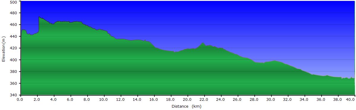
June 4, 2011: From Tucumán to Famaillá (Profile)
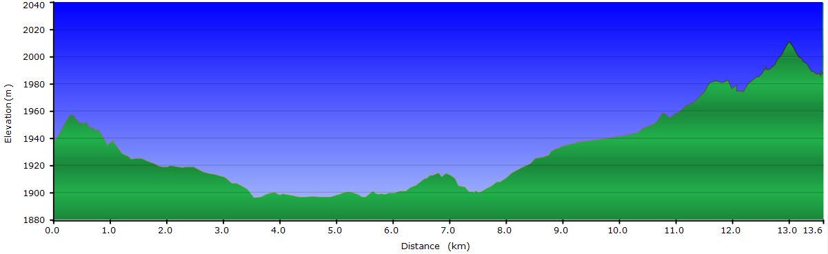
June 5, 2011: From Famaillá to El Mollar (Profile)
June 6, 2011: From El Mollar to Tafí del Valle (Profile)
June 7, 2011: From Tafí del Valle to Amaicha del Valle (Profile)
June 8, 2011: Visit to the Pachamama Museum and back to Tucumán
June 9, 2011: Picking up the charger and return to Amaicha
June 10, 2011: From Amaicha to Cafayate (Profile)
June 11, 2011: Quebrada de las Conchas (Shells Canyon) (out and back)
June 12, 2011: From Cafayate to Calchaquí river (Profile)
June 13, 2011: From Calchaquí river to Los Molinos (Profile)
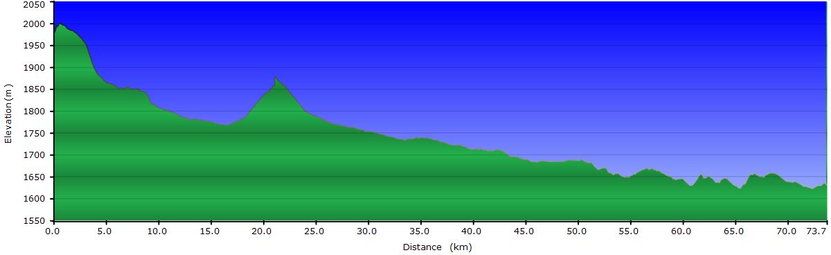
June 14, 2011: From Los Molinos to Cachi (Profile)
June 15, 2011: From Cachi to RP33 road (Profile)
June 16, 2011: From RP33 road to Salta (Profile)
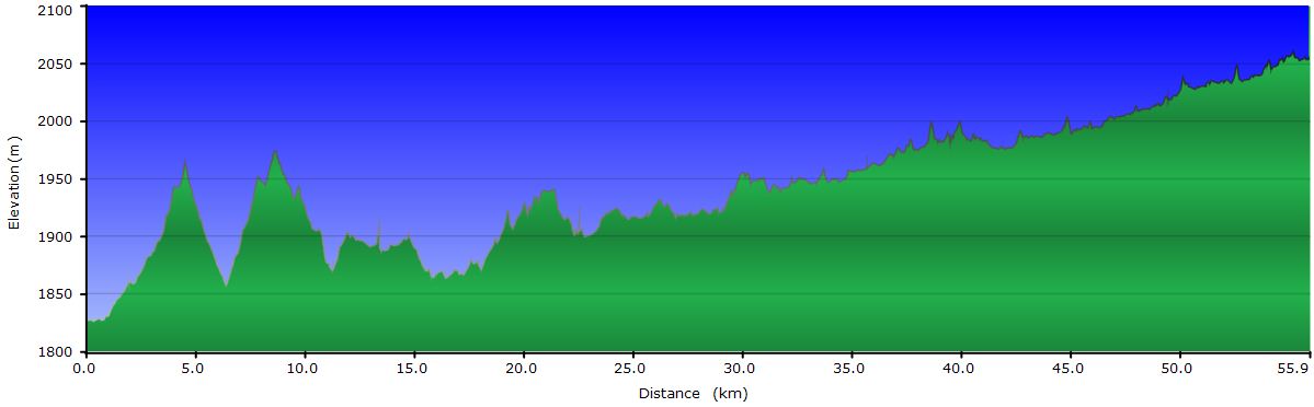
Profile for the entire stage (except Quebrada de las Conchas):

June 4, 2011: From Tucumán to Famaillá
Yesterday we had another experience with the bureaucracy of Argentinean postal service. Our battery charger has arrived to Argentina, but it’s in customs. In the Tucumán central office, shipments can only be collected on Tuesday and Thursday morning. Upon receipt of the notice that the package has arrived, one has to call to request a day and time to pick it up. The customs office charges you a daily fee for each day you delay in picking it up. And to round it up, at the time of picking it up, you must pay an import tax of 50% of the received product value. Anyway, a mixture of desperation and helplessness that we have to accept to be able to charge the batteries. Nevertheless, we are fortunate to meet Sandra at the customer service. She offers to be our intermediary and that greatly facilitates all the procedures. She tells us that the charger may not arrive to Tucumán till next Tuesday. The idea of staying in Tucumán 5 or 6 more days is not appealing at all so we decide to leave Tucumán towards Tafí and return by bus once we know the charger has cleared customs.
Leaving Tucumán by road is terrible. In addition to the overcast day and the horrible traffic, the road crosses a series of villages without interest. The rest of the route passes through endless plantations of sugarcane, one of the main income sources for the region. After about 25 mi, we get to Famaillá, a small town that is not mentioned in our travel guide, but it should, first of all because it’s Argentina´s capital of the empanada (a sort of pie filled with meet), but also for other reasons. Next to the road they are building a replica of the Cabildo de Buenos Aires (Buenos Aries old City Hall) to honor the independence of South American countries.
 It´s been raining for a while and now it seems that it intensifies which is the perfect excuse for us to finish our day here. We settle at the Hotel Famaillá and after the shower, we go out to visit the village without too many expectations. We're looking for the Avenue of the Sculptures and asking the locals for directions we end up witnessing the rise of the supervirgin. Right next to the road is the Walk of Worship. It displays a series of statues honoring various saints, arranged in line along a wall adorned with murals. There is also a large scale representation of Jesus and the 12 Apostles. But it’s at the end of the walk where we find a statue of the Virgen del Carmen about 24 feet high at the top of an artificial mountain from which a waterfall flows. The show is totally from Las Vegas. The virgin rises from inside the mountain while Schubert's Ave Maria and other religious pieces dedicated to the Virgin sound through the speaker system. When it reaches the highest position, she rotates around herself to delight the spectators who have gathered here brought by tour operators.
The fine rain is still falling when the supervirgin begins to descend, at which point we head back to the main square to have dinner and back to the hotel.

June 5, 2011: From Famaillá to El Mollar
 Before leaving Famaillá we ride along the Avenue of the Sculptures (finally found it). This is an avenue that displays art work by artists from all over the country and other countries as well, whether in wood, metal or stone. Many motifs are inspired on the local indigenous cultures, but others are more abstract. For the size of the town, we have been impressed by the cultural activity it has.
As we turn into secondary roads, the traffic decreases. Our route climbs to Tafí del Valle going through an area of rainforest known as the Yungas. The road climbs from 1200 to 5700 feet, crossing the forest from the very bottom to the top, finally giving way to high pastures. On top of the steep slopes, the vegetation in the Yungas is impenetrable. The winding road climbs relentlessly negotiating the topography of the area. Unfortunately, a thick fog bank hides the view of the deep valley we follow. Along the way there are a series of pessimistic signs pointing undefined sites. Names such as The Refrigerator, Evil´s Crest and World's End, do not help progress. The dense fog, the double-decker buses passing up and down and our tiredness make us consider in a couple of occasions to stop for the day. The problem is that there is no place to pitch the tent, unless it is in a curve or in some space next to the road. We keep climbing and we get to the statue of the Indian, erected in honor of the Indians of the Calchaquí valleys.
 Towards the end of the climb, the fog starts to become less dense. When we get to the last curves, we finally see the sun for the first time in the last few days. This encourages us to continue to El Mollar, first village of the valley, at almost 6000 feet of altitude. Just before the pavement becomes horizontal, we stop at a stall next to the road to buy goat cheese and walnuts covered with dulce de leche. Once installed on a hostel in El Mollar we devour everything edible we carry. It is too late to visit the menhirs, so we leave it for tomorrow.
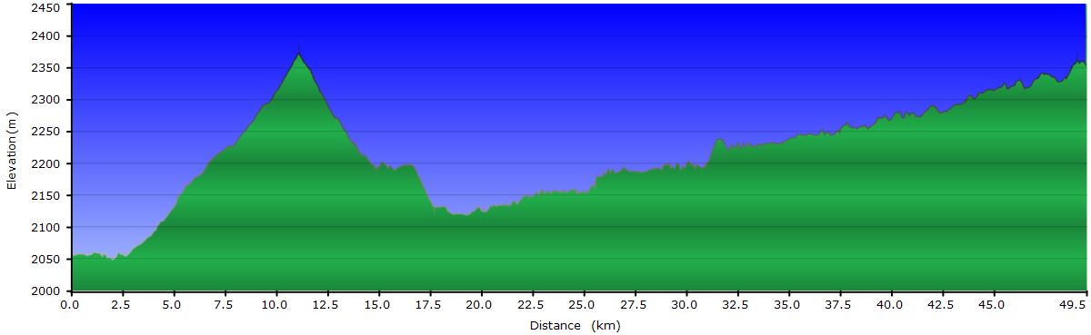
June 6, 2011: From El Mollar to Tafí del Valle
 After yesterday´s effort, we are not in the mood to face the uphill of El Infiernillo, some 3000 feet of altitude. So today we take it easy and just ride to Tafí del Valle, about 10 mi from El Mollar. Before leaving the village we visit the modest archaeological museum. In fact, it only shows the menhirs, some of them engraved with geometric shapes and human faces that the pre-Inca cultures left scattered throughout the valley. Some of these designs have been taken for the crafts sold in the area.
Instead of driving on the main road, we take a dirt road across the dam that goes between disperse houses. Once in Tafí we walk around town. This is a summer resort for the people of Tucumán, escaping the heat of the summer in the capital. In our opinion, Tafí has a better reputation than it deserves. Maybe in summer, when the grass is green, the scenery is nicer, but right now it doesn’t have much charm. One of our tasks is to find out the schedules of the busses going to Tucumán to pick up the battery charger. In the afternoon, we dedicate some time to bike maintenance. After that is dinner time. Today we will enjoy what will be the last lamb BBQ.
June 7, 2011: From Tafí del Valle to Amaicha del Valle
Today´s leg includes the Infiernillo pass up and down to the town of Amaicha. Fortunately, the rise is almost entirely paved. The slope is reasonable but it´s a 12.5 mi continuous climb. As we go up we have a better view of the valley, but it doesn´t improve our impression of the area.

At last we reach the pass and begin the downhill which, except for a small uphill, descends the 3000 feet we just climbed. On this side, the asphalt is in pretty bad shape and we cannot take advantage of gravity as we would like. The scenery improves considerably. The candelabra cacti, much more abundant, dot the hillsides. At the bottom of the valley, stands the National Route 40 that we will follow for a few days through the heart of the Valles Calchaquíes. Across the road, we can see the bare slopes of the precordillera, rich in minerals and, in the distance, the Nevados de Cachi to the North.

Amaicha´s main interest is the Pachamama Museum that we will visit tomorrow, since it is already closed when we have pitched the tent and taken a shower in the campsite Los Algarrobos. The village itself is tiny. It takes us 10 minutes to go around with the bikes. Although it is 6 pm, most shops are still closed. We end up at the gas station where in addition to serving coffee and sodas, they have Wi-Fi. After it gets dark, we ride around the town again in search of grocery stores to buy ingredients for a salad. As usual the selection is limited to a few vegetables: tomatoes, carrots, avocado (this time giant but blander than the Haas type) and beets. The lettuce is a little withered. When we return to the campsite, the temperature is still acceptable and we have dinner at a table outside, but when we are done it's cold and we get into the tent to read and write.
June 8, 2011: Visit to the Pachamama Museum and back to Tucumán
 The Amaicha Pachamama Museum is the work of Héctor Cruz, an artist of the valley which, after studying the pre-Inca cultures, decided to use them as inspiration for his work. This is an outdoor museum where the building walls and floor are decorated with the designs of the ancient people of the valley. There are also several stone and iron sculptures depicting the gods of these peoples, mainly the sun and the moon, as well as major characters in their hierarchy like the shaman. Of course, works relating to fertility, both land and the humans abound. One building houses a Museum of Geology with information about the mines in the valley as well as samples of minerals and semiprecious stones found there. It even has a replica of a mining gallery which you can go through. Another of the rooms displays archaeological finds of local tribes and reproduces scenes of daily life. The last building you can visit contains a collection of pottery and wall draperies by Cruz.
") Halfway through the visit we have to leave the museum to call our partner in the Tucumán post office. Sandra reports that the charger has arrived and tomorrow we can pick it up at customs. Great. We go back to finish the museum´s visit, to see some sections more closely and prepare to take the bus to Tucumán this afternoon.
Halfway through the visit we have to leave the museum to call our partner in the Tucumán post office. Sandra reports that the charger has arrived and tomorrow we can pick it up at customs. Great. We go back to finish the museum´s visit, to see some sections more closely and prepare to take the bus to Tucumán this afternoon.
The trip doesn´t have much interest, since we have already done it by bike. However, the stretch through the Yungas is spectacular today since there is no fog. We can see the exuberant forest much better and the depth of the canyons through which streams run.
At Tucumán, we stay at a hotel near customs to simplify our lives. Tomorrow we expect a day full of red tape.
June 9, 2011: Picking up the charger and return to Amaicha
We show up at the customs office at opening time. We ask for the clerk that has our package and submissively follow the process to collect it. First, you have to pay a few pesos simply because you showed up to pick it up. The clerk takes us to another floor of the building where another person opens the package for inspection. Since it´s under Judit´s name, I’m asked to sit and wait. Although Judit uses all her weapons to avoid the import tax, we end up paying 50% of the charger´s value. Since we were ready for this, the anger only lasts for a while.
Freed from all the paperwork and with the charger in our hands, we head to the bus terminal to return to Amaicha and continue our ride as if nothing had happened, disregarding the fact that the shipping cost and taxes are higher than the charger value itself. Besides, we have to carry the two chargers until we test the new one and arrive to Salta to ship the broken one back.
Once at the campsite, after 4 hours of travel, we check the new one for proper operation and we start making plans for tomorrow.
June 10, 2011: From Amaicha to Cafayate
After a pleasant descent, we join the RN40 to get to the ruins of Quilmes in a few miles. The Quilmes people resisted the Inca and Spanish invasions fiercely, for a while at least. In particular, the Spanish had a hard time to subdue them. Once defeated, they were taken from the valley to the outskirts of Buenos Aires on foot on a journey that lasted months and cost the lives of many. Once in the "New" Quilmes, they were forced into the encomienda system, basically a form of slavery. Today, in New Quilmes, the famous Argentinian beer named after them is brewed. The beer and the ruins are all that remains related to them.

The city was organized into classes, the more important or powerful the person was the further up the hillside he or she lived. Down on the plain, lived the peasants; above, the nobility, and the wise men at the top of the mountain. The city was built between two rocky spurs that provided a defense against attacks. Also, along the crest of both they built several pucarás or surveillance checkpoints. The houses were constructed partly buried, with walls more than 3 feet thick. The entrance was arranged in a spiral shape to reduce the force of the wind coming in, so common in the area. The homes were inhabited by several families and arranged around a central courtyard. Attached to the walls of the houses they built porches with straw roofs for sun protection. All of them had a room to grind corn. To do this they first used a stone mortar in which they crushed the grains. After that, part of the corn was ground finer to prepare other meals. The houses of the nobility were occupied by a single family and therefore smaller. Narrow aisles communicated the homes one with each other. From the pucarás one can appreciate the organization that these people had before the arrival of the invaders. You can also see part of the defensive walls around the city. Walking through the city areas that have not been restored, we find many pieces of pottery. Some of them decorated with the colors and designs we have seen in the Museo de la Pachamama. Dario, our guide, keeps them under a bush to show them to the following tourists. He complains about the restoration project. It’s stopped until the litigation is resolved with the current owner for misappropriation of archaeological remains. He even built a hotel at the base of the city using the stones from the Quilmes homes. It seems the same technique the Spanish used to build the cathedral of Cuzco with blocks of Inca buildings...
Route 40 is very flat in this area and we arrive to Cafayate, the main town of the valley, with no problems. Around Cafayate vineyards abound, or more precisely, high elevation vineyards, as they are called here. These are wines with higher alcohol content as we will check in the days ahead.

For dinner we go to one of the peñas (local traditional clubs), places where traditional music is played by local groups. Unfortunately, we are the only customers for the night and not enough people to call the musicians. The grilled lamb doesn’t match the expectations the waiter set and we complain about it. He brings another full grill, this time with the best parts of the poor lamb. Again, we go back to the campground with our bellies rubbing the bike frame. At least this time we are not drunk, as the wine was quite awful.
June 11, 2011: Quebrada de las Conchas (Shells Canyon) (out and back)

The RN68 road goes directly from Cafayate to Salta through the Quebrada de las Conchas, a canyon that has an impressive variety of landforms. The combination of diverse sedimentary strata and erosion have shaped the rocks creating windows, obelisks, colorful gorges, etc. A few miles from the start we turn right onto a sandy track towards a vertical wall of reddish tones. A few hundred yards ahead a motorist, who turns out to be a ranger, informs us that it’s not allowed to ride in the area, so we keep walking. He also gives us a brochure describing the main points of interest of the quebrada and their location. We still walk a little farther but the photos in the brochure, although very saturated, show more spectacular formations and colors farther down the main road.

The next point of interest is Las Ventanas (The Windows). Here wind erosion has carved the mud walls leaving openings. Then the Obelisk comes, which has resisted erosion and stands proudly pointing to the sky. The views of colorful layers occur almost without interruption but it is in another diversion of the road where we find the best ones . At the beginning of this other track, there are walls with an accumulation of thin unimaginably twisted layers. Following the track farther in, the landscape is amazing. We have never seen a concentration of rocks of different colors like this. On one hillside colors blend to transition smoothly. On some others, the tone boundaries are well defined. From one of the hillsides along the wash we follow, thin layers of a fragile white mineral emerge from the red sandstone. Again, we leave the area in search of the other points of interest in the booklet, but this is the most spectacular by far.
We go through the Yesera, La Casa de los Loros, El Fraile and Los Castillos but we these don’t catch our attention. At the end of our ride we arrive to the Garganta del Diablo (Devil’s Throat), a narrow canyon through which we climb up until we find a vertical wall of over 300 feet. Unfortunately, there are graffiti on the walls with messages as stupid as their authors.
 With so many photo stops and detours, we are already late for the 30 mi ride back to Cafayate, so we take a bus. It seems surprising that the quebrada has not been declared National Park with all the spectacular scenery it has.
The restaurant we choose for dinner is an excellent decision. At Macacha we enjoy both the food and the wine. On top of that, we engage in a conversation with a couple of Argentines visiting the valley and we have a good time chatting with them. With the digestion complete and the alcohol practically diluted we go back to the tent.
June 12, 2011: From Cafayate to Calchaquí River
 A few miles from Cafayate, the pavement of the RN40 disappears and we meet again with our old friends: the ripio and serrucho. Today's ride goes across villages so small that we have to watch carefully to realize they exist. We are talking about dusty villages of only 4 or 5 houses in the middle of absolutely nothing. It’s astonishing that there are people living here. We wonder how they live, what they do, how they spend the hours. In the afternoon, we pass through San Rafael and ask to the only human being we see on the street for a store to buy more water. She indicates a house half a mile back. We wake up the owner from a long nap to sell us a bottle of soda between yawns. With no anecdotes or landscapes worth of reporting, we arrive at the Calchaquí river bridge and pitch the tent off the road behind a small grove.
June 13, 2011: From Calchaquí river to Los Molinos
 Today is a lot more interesting than yesterday. Shortly after crossing the bridge, we enter into the Quebrada de las Flechas (Arrows Gorge). Precambrian sediments have been folded, leaving the layers at angles close to 90 degrees. No striking colors here, but the pointing formations emerging from the ground are spectacular. The RN40 passes between them in the so called “cuts”. At the exit of the gorge is Angastaco, a small but dynamic village. The main square is under renovation, there is free Wi-Fi, and the tourist office is open and has a variety of helpful brochures. At the entrance of the village a sign warns the rushed drivers, "Drive carefully. In this town, we don’t have children to spare”. The empanadas in the little restaurant where we stop are so good that we end up eating 4 each. Going back to the RN40, the king of the hill says bye with some braying.
 In this area we see several flocks of noisy parrots. One associates parrots with the Amazon jungle and not with the harsh land around. A little farther we arrive to the Church of El Carmen, the oldest in the valley. The walls are made of adobe and the roof with cactus wood. It houses replicas of the paintings of the arquebusier angels. This is a very interesting collection of paintings from the Cuzco school. The originals are in the church of Uquía in the Quebrada de Humahuaca that we’ll visit in a few weeks. We will tell then the story behind the paintings.
 Our progress on the dirt track is slow and the flats due to cactus thorns are not precisely helpful. After replacing the two spare tubes we carry I realize my front wheel is loosing air. The sun is going down but we manage to arrive to Los Molinos by inflating it a couple of times and pedaling faster. We still have time to repair one of them and take a shower before they close the stores. We shop around and, as usual, we buy too much food. In the kitchen of the hostel we prepare a steak with fried eggs and a giant salad. In addition, we eat half of the home bread we just bought. The fruit, cheese, canned tuna and the rest of the bread will be for tomorrow.
June 14, 2011: From Los Molinos to Cachi
Before leaving we would like to visit some of the mills that give the name to the village. We stop a villager pedaling uphill vigorously (I know, I know we shouldn’t have done it) and ask him about the mills. There is only one left, just before crossing the river and it no longer works. Indeed, the construction is there, the grinding stone and mechanisms as well, but everything is abandoned. In a few years from now, the summer storms will probably have collapsed the mud walls and everything will be ruined.
 The climb to the pass before going down to Seclantás is easy. Here again the landscape is dotted with large cacti. In Seclantás we stop for lunch at the Inti Raymi restaurant. Here the food is cooked in a traditional way. They offer dishes such as pickled beans, chuchoca and charquisillo. The owner explains how he and his wife prepare them. He shows us a cayote, a kind of watermelon-like pumpkin, used to produce the sweet cayote. He also recommends a couple of places to visit that still weave the traditional way and gives us directions to the Artisans Road.
The Artisans Road runs parallel to the RN40 but on the other side of the river. Here you can find authentic traditional fabrics and handicrafts. At Odila Mamani’s home we see how the typical Salta’s poncho is woven. In the long loom the fabric is already prepared and the weaver has already completed a couple of feet. While he explains how the pedal system functions, he keeps working with automatic but precise movements after the many many times he has repeated them. For the fabric to be thick he must compact every pass with strong strokes of spade. After 4 or 5 days of work, the fabric for a couple of ponchos is complete. Odila complains about some of the other artisans. Despite showing a loom and put someone to work when the tourists show up, they just resell the fabrics.

Cachi is our destination today. It’s the last town we visit on the Calchaquí Valleys. It still has the old colonial buildings around the main square. At night, the white walls of the houses reflect the mercury lamps light creating a pleasant and quiet atmosphere to wander. This is how we find the Ashpamanta restaurant where Veronica and her partner prepare succulent pasta dishes and pizzas. She, like others we have found along the way, left the stress-filled life of the cities to find a relaxing inner peace in the small villages. After satisfying our appetite, we exchanged stories in a very pleasant conversation.
June 15, 2011: From Cachi to RP33 road
After repairing the other tubes in the courtyard of the hostel, we take a walk around the square where artisans have exposed their work in wood, polished stones and fabrics. At the moment our goal is the Archaeological Museum, which exhibits a good collection of archaeological materials from indigenous groups in the area. On the way out we buy a box made of various wood types displaying a typical image of the valley. Cachi is a village that requires more than one morning to visit it, but less than a day. Without having walked around enough, we set off.

Our route traverses the Cardones National Park, climbs up La Piedra de Molino pass and goes down the Bishop’s Slope to Salta. Today we can only do part of the climb up, since we started cycling after noon. Crossing the Los Cardones Park is nothing spectacular. In fact, we have seen better examples of the candelabra cacti elsewhere in the valley. A stretch of the road follows the Tin Tin stretch, part of the Inca Trail. We continue climbing and around mile 30 we move away from the road and camp on the sandy bed of a wash, under the watchful eye of a guanaco. As always, when the sun disappears, the cold falls and we take shelter in our sleeping bags. Before going to bed we go to empty the bladders and we are amazed by the starry sky above us. After the night visit in the Leoncito National Park, now we recognize some of the stars and constellations of the Southern Hemisphere. We need to rest for tomorrow if we want complete the remaining 70 mi to Salta, so we go to sleep early.

June 16, 2011: From RP33 road to Salta
 We go out of the tent just as the sun line crosses the wash where we have slept. We drag the bikes to the road and we resume climbing up the road. When we get close to the pass, a headwind blows as usual. A flock of caranchos plays with the gusts that annoy us so much. Upon reaching the top a big smile appear in our faces when we see how the road goes down and down and down. The curves of the Cuesta del Obispo extend out of sight. Just what we need for the today, go down. When we reach the bottom of the valley we have lost about 6600 feet in about 38 mi. Much of the steeper section is unpaved, but anyway, it's great to add miles this way, without pedaling.
 The 23 mi that remain to Salta have no interest. The only thing remarkable is the snake we almost run over and the heavy traffic in the satellite towns of the capital. However, as we approach Salta, we find a bike path that will relieve us for some miles from the stress of riding between cars. It’s always so relaxing to get to the hostel and take a hot shower... We prepare a salad and go to bed. Tomorrow we will walk around Salta “the cute”, so cute that you will fall in love with it, as the tourist posters advertise.